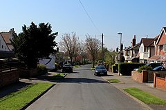
Arthursdale
| Arthursdale | |
|---|---|
 Nook Road | |
Location within West Yorkshire | |
| OS grid reference | SE3737 |
| Metropolitan borough | |
| Metropolitan county | |
| Region | |
| Country | England |
| Sovereign state | United Kingdom |
| Post town | LEEDS |
| Postcode district | LS15 |
| Dialling code | 0113 |
| Police | West Yorkshire |
| Fire | West Yorkshire |
| Ambulance | Yorkshire |
Arthursdale is an area within the village of Scholes in West Yorkshire, England. It is a small area immediately to the north of Rakehill Road in Scholes, near the former Scholes station on the closed Cross Gates–Wetherby line.[1][2] It was established around 1900 on glebe land bought by farmer, property developer and brick works manager Arthur Chippindale and included Whinmoor Farm.[3] A cricket club named after the settlement was formed in 1929.[4]
The glebe land on which the housing in the area is built was originally part of the wastes & common land of Whinmoor and was awarded to the Rector of Barwick in Elmet under the 1804 Barwick in Elmet Enclosure Award.[5]
References[edit]
- ^ Yorkshire CCIV.SW (includes: Barwick in Elmet and Scholes.) (Map). 1:10560. Ordnance Survey. 1909. Retrieved 9 April 2018.
- ^ Yorkshire CCIV.SW (includes: Barwick in Elmet and Scholes.) (Map). 1:10560. Ordnance Survey. 1952. Retrieved 9 April 2018.
- ^ "The Development of Arthursdale". The Barwicker (82). Barwick-in-Elmet. June 2006. Retrieved 9 April 2018.
- ^ "Arthursdale Cricket Club 1929-99". The Barwicker. Barwick-in-Elmet. March 2000. Retrieved 9 April 2018.
- ^ "West Yorkshire Archives Service". West Yorkshire Archive Service. Retrieved 3 September 2019.
External links[edit]
![]() Media related to Arthursdale at Wikimedia Commons
Media related to Arthursdale at Wikimedia Commons

