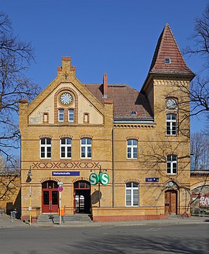
Berlin Wollankstraße station
This article includes a list of general references, but it lacks sufficient corresponding inline citations. (February 2024) |
Wollankstraße | |||||||||||||||||||||
|---|---|---|---|---|---|---|---|---|---|---|---|---|---|---|---|---|---|---|---|---|---|
| Hp | |||||||||||||||||||||
 | |||||||||||||||||||||
| General information | |||||||||||||||||||||
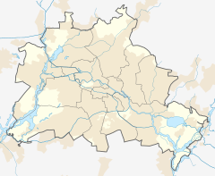
| Location | Pankow, Pankow borough, Berlin Germany | ||||||||||||||||||||
| Coordinates | 52°33′55″N 13°23′32″E / 52.56528°N 13.39222°E | ||||||||||||||||||||
| Line(s) |
| ||||||||||||||||||||
| Platforms | 2 | ||||||||||||||||||||
| Other information | |||||||||||||||||||||
| Station code | 6871 | ||||||||||||||||||||
| DS100 code | BWOK | ||||||||||||||||||||
| Category | 4 [1] | ||||||||||||||||||||
| Fare zone | |||||||||||||||||||||
| Website | www.bahnhof.de | ||||||||||||||||||||
| History | |||||||||||||||||||||
| Opened | 10 July 1877 | ||||||||||||||||||||
| Electrified | 5 June 1925 | ||||||||||||||||||||
| Previous names | 1877-1879 Prinzenallee 1880-1893 Prinzen-Allee (Pankow) 1893-1911 Pankow (Nordbahn) 1911-1937 Pankow Nordbahn | ||||||||||||||||||||
| Key dates | |||||||||||||||||||||
| 1893 | current building erected | ||||||||||||||||||||
| 1945, late April - 10 June | operation interrupted | ||||||||||||||||||||
| 1984, 9 January - 30 September | operation interrupted | ||||||||||||||||||||
| Services | |||||||||||||||||||||
| |||||||||||||||||||||
 | |||||||||||||||||||||
| Location | |||||||||||||||||||||
Berlin Wollankstraße (German: Bahnhof Wollankstraße) is a railway station in the Pankow district of Berlin, Germany. It is served by the Berlin S-Bahn and several local buses.
History[edit]

The station opened as Bahnhof Prinzenallee on 10 July 1877 at the Nordbahn (Berlin–Stralsund Northern railway) from Berlin to Neubrandenburg. In 1893 it received the name Pankow (Nordbahn), while the former Pankow railway station was called Pankow-Schönhausen. The Nordbahn line was connected to the S-Bahn system on 5 June 1925 and the station was renamed Wollankstraße on 3 October 1937.
After World War II traffic restarted first with steam on 11 June 1945. On 19 July 1945 the electric train service resumed. From 1945 the station was situated next to the border between East and West Berlin, on the east side, in Berlin's Pankow district. In 1961 the Berlin Wall was built just to the east of the station. The station remained in service within the West Berlin S-Bahn system, and could only be reached by passengers from the adjacent West Berlin locality of Gesundbrunnen (then part of Wedding borough). The entrances to the east remained bricked up until 1989. Nevertheless, during this period, the station was staffed and controlled by East German railway officials, and while the West Berlin S-Bahn trains were passing between Wollankstraße station and Friedrichstraße station, they were driven by an East German State railway driver who returned home to East Berlin every day. This was at a time when only the select few were allowed to exit East Germany. Friedrichstraße station was situated inside East Berlin, but the West Berlin S-Bahn service operating from that station was not accessible to East Berliners.
In popular culture[edit]
The station features prominently in the 2011 thriller The Debt as a location along the border where an attempt is made to smuggle a Nazi war criminal from East Berlin to West Berlin. The film suggests that it would be possible to access a train stopped at the station from an adjacent property. In reality, the scenes depicted in the film could not have taken place, since the station is built on a viaduct and trains are elevated above street level.
References[edit]
- ^ "Stationspreisliste 2024" [Station price list 2024] (PDF) (in German). DB Station&Service. 24 April 2023. Retrieved 29 November 2023.
- ^ "Der VBB-Tarif: Aufteilung des Verbundgebietes in Tarifwaben und Tarifbereiche" (PDF). Verkehrsbetrieb Potsdam. Verkehrsverbund Berlin-Brandenburg. 1 January 2017. Archived from the original (PDF) on 27 October 2020. Retrieved 25 November 2019.
External links[edit]
- Station information (in German)

