
Beuningen, Overijssel
Beuningen | |
|---|---|
Village | |
 Aerial view of Beuningen | |
 Beuningen Location in the province of Overijssel in the Netherlands  Beuningen Beuningen (Netherlands) | |
| Coordinates: 52°21′31″N 6°59′56″E / 52.35861°N 6.99889°E | |
| Country | Netherlands |
| Province | Overijssel |
| Municipality | Losser |
| Area | |
| • Total | 23.12 km2 (8.93 sq mi) |
| Elevation | 29 m (95 ft) |
| Population (2021)[1] | |
| • Total | 970 |
| • Density | 42/km2 (110/sq mi) |
| Time zone | UTC+1 (CET) |
| • Summer (DST) | UTC+2 (CEST) |
| Postal code | 7588[1] |
| Dialing code | 0541 |
Beuningen (Dutch pronunciation: [ˈbøːnɪŋə(n)] ⓘ) is a village in the eastern Netherlands. It is located in the municipality of Losser, Overijssel and situated along the river Dinkel, in a mainly rural area, approximately one kilometre south of Denekamp.
History[edit]
The village was first mentioned in the late-10th century as "in Baningi", and means "settlement of the people of Bono (person)".[3] Beuningen started as a collection of farms south of Denekamp. It started to develop after World War II.[4]
The estate Borgbeuningen was built in 1709 on the former site of a medieval castle. The estate is surrounded by a large park whose lanes are aligned with the church towers of the region. In the centre of the forest, there is a rectangular and crucifix-shaped pond.[4]
Beuningen was home to 699 people in 1840.[5] Beuningen used to be part of the parish Denekamp, in 1818 the boermarke (predecessor of municipality) Beuningen became part of the municipality of Losser.[5]
A Roman Catholic church from 1948 is located in the village,[6] and Beuningen was elevated to a village.[5] A campsite, a soccer field and a forest are located just outside the village.
In popular art[edit]
Many scenes of the fictional village Dinkelo in the regional soap opera Van Jonge Leu en Oale Groond were shot in Beuningen..[7]
Gallery[edit]
-
 Maria church: Onze Lieve Vrouwekerk
 -
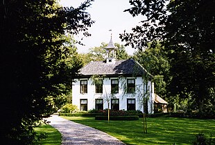 Borgbeuningen
 -
 Barns near Singraven


References[edit]
- ^ a b c "Kerncijfers wijken en buurten 2021". Central Bureau of Statistics. Retrieved 13 April 2022.
- ^ "Postcodetool for 7588PA". Actueel Hoogtebestand Nederland (in Dutch). Het Waterschapshuis. Retrieved 13 April 2022.
- ^ "Beuningen - (geografische naam)". Etymologiebank (in Dutch). Retrieved 13 April 2022.
- ^ a b Ronald Stenvert & Jan ten Hove (1998). Beuningen (in Dutch). Zwolle: Waanders. ISBN 90 400 9200 1. Retrieved 13 April 2022.
- ^ a b c "Beuningen (Overijssel)". Plaatsengids (in Dutch). Retrieved 13 April 2022.
- ^ Parochie Lumen Christi.nl - locatie Beuningen
- ^ "Van Jonge Leu en Oale Groond". Faculty of Spatial Sciences of the University of Groningen (in Dutch). Retrieved 13 April 2022.
| International | |
|---|---|
| Geographic | |
| Other | |