Camperdown, Tyne and Wear
| Camperdown | |
|---|---|
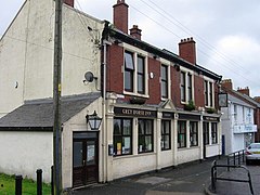
 The Grey Horse Inn | |
Location within Tyne and Wear | |
| Metropolitan borough | |
| Metropolitan county | |
| Region | |
| Country | England |
| Sovereign state | United Kingdom |
Camperdown is a village in the metropolitan borough of North Tyneside, Tyne and Wear, England. Camperdown is just south of Burradon,[1] and the two villages are closely linked.[2] Both villages had coal mines.[2] Until 1974 it was in Northumberland.
History[edit]
On 1 April 1899 Camperdown became a separate civil parish being formed from Longbenton, on 1 April 1912 the parish was abolished and merged with Longbenton.[3] In 1911 the parish had a population of 918.[4] It is now in the unparished area of Longbenton.
See also[edit]
- The Battle of Camperdown, a naval battle in 1797
References[edit]
- ^ Alan Fryer. "Home - The Burradon and Camperdown Community Website". Retrieved 19 April 2016.
- ^ a b nechronicle Administrator (1 January 2012). "Seven interesting facts about Burradon & Camperdown". nechronicle. Retrieved 19 April 2016.
- ^ "Relationships and changes Camperdown CP through time". A Vision of Britain through Time. Retrieved 28 January 2024.
- ^ "Population statistics Camperdown CP through time". A Vision of Britain through Time. Retrieved 28 January 2024.

