
Castell de la Fosca
You can help expand this article with text translated from the corresponding article in Catalan. (June 2016) Click [show] for important translation instructions.
|
Poblat ibèric de Castell | |
 entrance to the Castell de la Fosca | |
 Location in Catalonia | |
| Alternative name | Iberian Town of Castell |
|---|---|
| Location | Cala de Castell, Palamós, Catalonia, Spain |
| Region | Iberian Peninsula |
| Coordinates | 41°51′37″N 3°9′32″E / 41.86028°N 3.15889°E |
| Type | settlement |
| History | |
| Founded | 6th century BC |
| Abandoned | 1st century AD |
| Cultures | Iberian Indigetes |
| Site notes | |
| Archaeologists | Lluís Barceló i Bou |
| Condition | ruin |
| Ownership | Generalitat de Catalunya |
| Management | Archaeology Museum of Catalonia |
| Public access | yes |
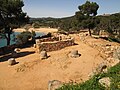
Castell de la Fosca or Punta del Castell is an ancient Iberian settlement or oppidum sited on a rocky promontory at the north end of the beach called Platja de Castell, about 2 kilometres (1.2 mi) ENE of Palamós (Baix Empordà), on the Costa Brava.
The settlement, which seems to have been inhabited from the 6th century BC to the 1st century AD, was protected by a wall and two square towers. Archaeologists, first in the 1930s and 1940s, and now in a series of excavations begun in 2001, have discovered 64 storage pits and two water cisterns, as well as pottery, amphorae (both locally made and imported), millstones, weights for fishing nets, lamps, agricultural tools and surgical instruments, coins, pieces of bronze, Iberian inscriptions, and the bases of two columns.[1]
Gallery[edit]
-
 Ruined stone columns
 -
 View of the promontory
 -
 The entrance from Platja de Castell


See also[edit]
References[edit]
External links[edit]
- "Panoramic view of the Iberian village". Panoràmiques 360º. Archived from the original on 28 March 2009. Retrieved 28 June 2016. (Panoramic view of the Iberian village)
- Pre-Roman peoples of the Iberian Peninsula
- Archaeological sites in Catalonia
- 6th-century BC establishments
- Buildings and structures completed in the 6th century BC
- Former populated places in Spain
- Baix Empordà
- 1st-century disestablishments
- Ruins in Spain
- Iberians
- Buildings and structures in the Province of Girona