Cheloor
Cheloor | |
|---|---|
village | |
| Coordinates: 10°20′22.96″N 76°11′43.97″E / 10.3397111°N 76.1955472°E | |
| Country | |
| State | Kerala |
| District | Thrissur |
| Languages | |
| • Official | Malayalam, English |
| Time zone | UTC+5:30 (IST) |
| PIN | 680121 |
| Telephone code | 0480 |
| Vehicle registration | KL-45 |
| Nearest city | Thrissur |
| Lok Sabha constituency | Thrissur |
| Vidhan Sabha constituency | Irinjalakuda |
| Municipality ward | Cheloorkavu, Ward No.27 |
| Councillor | Soniya Giri, INC, (2020 -) |


Cheloor is a place in Irinjalakuda municipality, Thrissur district in the Indian state of Kerala. It is around 1 km from the famous Koodalmanikyam Temple.
Location[edit]
Cheloor is bordered by Edakulam on the south, Edathirinji on the west, Kanteshwaram on the north and Irinjalakuda town on the east.
Irinjalakuda and Moonupeedika are the nearest towns.
Transportation[edit]
Irinjalakuda Municipal Bus Stand and Irinjalakuda KSRTC Bus Stand are the nearest bus stands. Irinjalakuda Railway Station at Kalletumkara is the nearest railway station.
Places of worship[edit]
- Cheloor Kavu
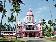
- St. Mary's Church
- Mariyaman Kovil
- Vettathu Ambalam
- Panokkil Ambalam
- Thamarath Sreerama Temple
Bank branches & ATMs[edit]
- South Indian bank, Do.No.387/1, Irinjalakuda-kakkathuruthy Road, P.o, Irinjalakuda, Kerala 680121
- Federal Bank ATM, KSRTC Bus Stand
- ICICI Bank ATM, KSE Vesta Dosa World
Petrol Pump[edit]
- Hindustan Petroleum HP Petrol Pump - Nakkara Fuels
