Draft:Aglomeracja rybnicko-jastrzębska
Submission declined on 7 May 2024 by The Herald (talk).
Where to get help
How to improve a draft
You can also browse Wikipedia:Featured articles and Wikipedia:Good articles to find examples of Wikipedia's best writing on topics similar to your proposed article. Improving your odds of a speedy review To improve your odds of a faster review, tag your draft with relevant WikiProject tags using the button below. This will let reviewers know a new draft has been submitted in their area of interest. For instance, if you wrote about a female astronomer, you would want to add the Biography, Astronomy, and Women scientists tags. Editor resources
|  |


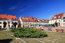
Rybnik-Jastrzębie Agglomeration[1] - a polycentric agglomeration in the western part of the Silesian Voivodeship, whose inner-city areas are large cities with county rights: Rybnik, Jastrzębie-Zdrój, Żory and adjacent urban communes: Pszów, Radlin, Rydułtowy and Wodzisław Śląski.


Agglomeration concepts[edit]
Agglomeration according to the marshal's office[edit]
In 2004, the Marshal's Office of the Silesian Voivodeship indicated the inner-city areas of the Rybnik-Jastrzębie agglomeration, which includes Jastrzębie-Zdrój, Pszów, Radlin, Rybnik, Rydułtowy, Wodzisław Śląski and Żory. The adjacent communes are functionally linked to the agglomeration: Gaszowice, Jejkowice, Marklowice, Mszana and Świerklany and the regional center Racibórz, supporting its development.
The Department of Strategic and Spatial Planning of the Marshal's Office assessed that the agglomeration is an economically, culturally and scientifically strong nodal center connected with the Ostrava agglomeration and the Opole Voivodeship. It was found that the Rybnik-Jastrzębie agglomeration tends to develop polycentric with the center in Rybnik and to increase the number of inhabitants of the agglomeration, as well as to develop settlements in transport corridors connecting the agglomeration with the Czech Republic and the Ostrava agglomeration through the former border crossing in Chałupki.
| City | population (2020-12-31[2]) | Area (2020-01-01[3]) [km²] | density of population [person/km²] |
|---|---|---|---|
| Jastrzębie-Zdrój | 83 477 | 85,33 | 978,2 |
| Pszów | 13 844 | 20,44 | 677,3 |
| Radlin | 17 759 | 12,53 | 1417,3 |
| Rybnik | 131 744 | 148,36 | 896 |
| Rydułtowy | 21 514 | 14,95 | 1451,5 |
| Wodzisław Śląski | 45 571 | 49,5 | 920 |
| Żory | 64 839 | 64,59 | 973 |
| inner city areas | 377 480 | 395,7 | 953,95 |
| gmina Gaszowice | 9 524 | 19,54 | 479,8 |
| gmina Jejkowice | 4 078 | 7,59 | 537,3 |
| gmina Marklowice | 5 412 | 13,69 | 395,3 |
| gmina Mszana | 7 582 | 31,22 | 242,9 |
| gmina Świerklany | 12 249 | 24,02 | 506,8 |
| total (agglomeration) | 416 325 | 491,76 | 846,6 |
See also[edit]
- Rybnik Coal Area (Rybnicki Okręg Węglowy)
- Metropolis GZM (Metropolia GZM)
References[edit]
- ^ "Charakterystyka strefy dla potrzeb oceny jakości powietrza - GIOŚ". powietrze.gios.gov.pl. Retrieved 2024-05-06.
- ^ Ludność. Stan i struktura w przekroju terytorialnym (Stan w dniu 31 XII 2010 r.) (PDF). Warszawa: Główny Urząd Statystyczny. 2011-06-10. ISSN 1734-6118.
- ^ Powierzchnia i ludność w przekroju terytorialnym w 2013 r. Warszawa: Główny Urząd Statystyczny. 2013-07-26. ISSN 1505-5507.

- in-depth (not just passing mentions about the subject)
- reliable
- secondary
- independent of the subject
Make sure you add references that meet these criteria before resubmitting. Learn about mistakes to avoid when addressing this issue. If no additional references exist, the subject is not suitable for Wikipedia.