
Draft:Sistema de Información Territorial e Infraestructura de Datos Espaciales del Principado de Asturias
| Submission declined on 15 December 2023 by Cerebellum (talk). This draft's references do not show that the subject qualifies for a Wikipedia article. In summary, the draft needs multiple published sources that are:
Where to get help
How to improve a draft
You can also browse Wikipedia:Featured articles and Wikipedia:Good articles to find examples of Wikipedia's best writing on topics similar to your proposed article. Improving your odds of a speedy review To improve your odds of a faster review, tag your draft with relevant WikiProject tags using the button below. This will let reviewers know a new draft has been submitted in their area of interest. For instance, if you wrote about a female astronomer, you would want to add the Biography, Astronomy, and Women scientists tags. Editor resources
|
| Submission declined on 13 July 2023 by Tutwakhamoe (talk). This submission is not adequately supported by reliable sources. Reliable sources are required so that information can be verified. If you need help with referencing, please see Referencing for beginners and Citing sources. |
 Comment: The article/draft was originally called "SITPA-IDEAS". Someone renamed it later, perhaps following some policy or recommendation. But I agree that the new name is too long, and the abbreviation "SITPA-IDEAS" should be used instead (for example, "MS-DOS" article isn't named as "Microsoft Disk Operating System"). MGeog2022 (talk) 16:27, 6 December 2023 (UTC)
- Comment: The title for this article is rather long. I recommend that this title be made shorter for readers to search the article easier. Toadette (Happy holiday!) 08:10, 6 December 2023 (UTC)
- Comment: Blogspot sites can not be used as sources. The official website of the subject should only be used to prove small details that other independent sources did not cover. It is recommended to use a number of significant coverage from reliable and independent sources to prove the claims on this article instead. Tutwakhamoe (talk) 12:00, 13 July 2023 (UTC)
SITPA-IDEAS (Territorial Information System and Spatial Data Infrastructure of the Principality of Asturias; in Spanish, Sistema de Información Territorial e Infraestructura de Datos Espaciales del Principado de Asturias) is a Spatial Data Infrastructure and geoportal where all kinds of geographic information of interest of Principality of Asturias are made available.[1][2] Its coordination, management and maintenance is the responsibility of General Directorate of Territorial Planning, through the Cartography Service, in collaboration with the different departments of the Government of Principality of Asturias, who either share the geographic information they generate, or work together with the Service, in order to generate new geographic information.[3]
History[edit]
SITPA (Territorial Information System of the Principality of Asturias) was started in 2000[1] by the Government of Principality of Asturias, in order to make available to the public the geographic information it had, because it was considered of great interest, not only for its own specific tasks, but also for other applications.[3]
The Spatial Data Infrastructure of Asturias, IDEAS, created in 2010[1], was later integrated along with SIPTA into the new SITPA-IDEAS geoportal,[4] launched in 2020.
Available contents[edit]
It has a download center,[5] from which it is possible to download basic cartography (topographic maps of Principality of Asturias at 1:5000 and 1:10000 scale, as well as other maps at different scales), aerial images from different years, an elevations model,[6] historical and thematic cartography, etc.
SITPA-IDEAS also includes a map viewer,[2] where thematic maps about topics such as animal species distribution[7] or mobile phone coverage[8] can be viewed.
License[edit]
Its contents are usually published under the terms of the Creative Commons-Attribution (CC-by 4.0) license.[9]
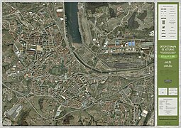
Gallery[edit]
- Orthophotomaps of Oviedo
-
 Oviedo - Center
 -
 Oviedo - East
 -
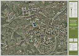 Oviedo - West


- Orthophotomaps of Gijón
-
 Gijón - Center
 -
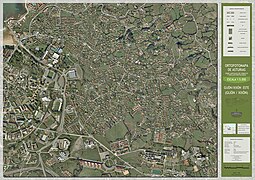 Gijón - East
 -
 Gijón - West
 -
 Gijón - South


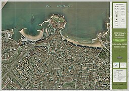
- Orthophotomap of Avilés
-
 Avilés

References[edit]
- ^ a b c "SITPA - IDEAS platform - Spatial data infrastructure of Spain (in Spanish: Plataforma SITPA - IDEAS - Infraestructura de datos espaciales de España)" (PDF).
- ^ a b "Principado de Asturias | Caso de Éxito - SITPA-IDEAS". www.esri.es (in European Spanish). Retrieved 2023-03-14.
- ^ a b "SITPA-IDEAS - SITPA - IDEAS". ideas.asturias.es.
- ^ "Sadim desarrollará el sistema de información geográfica regional". El Comercio: Diario de Asturias (in European Spanish). 2019-04-27. Retrieved 2023-03-07.
- ^ "Download center - SITPA - IDEAS". ideas.asturias.es (in Spanish). Retrieved 2022-06-30.
- ^ "Elevaciones del Principado de Asturias - Conjunto de datos". datos.gob.es (in Spanish). Retrieved 2023-12-03.
- ^ "La comarca, la zona de Asturias que más especies silvestres conserva" (in Spanish). Retrieved 2023-03-14.
- ^ Asturias, Redacción COPE (2022-10-13). "El Principado publica un mapa de cobertura móvil, pero ocultando el nombre de cada operadora". COPE (in Spanish). Retrieved 2023-03-14.
- ^ "Licenses and terms of use - SITPA - IDEAS". ideas.asturias.es (in Spanish). Retrieved 2022-06-30.
External links[edit]
Category:Geographic information systems Category:Geomatics