
Duncan, Casey County, Kentucky
Duncan, Kentucky | |
|---|---|
 Duncan, Kentucky | |
| Coordinates: 37°21′31″N 84°43′39″W / 37.35861°N 84.72750°W | |
| Country | United States |
| State | Kentucky |
| County | Casey |
| Elevation | 1,329 ft (405 m) |
| Time zone | UTC-5 (Eastern (EST)) |
| • Summer (DST) | UTC-4 (EDT) |
| Area code | 606 |
| GNIS feature ID | 507889[1] |
Duncan is an unincorporated community in Casey County, Kentucky, United States. Duncan is located at the junction of Kentucky Route 501 and Kentucky Route 837 12 miles (19 km) east-northeast of Liberty.[2]
References[edit]
- ^ "Duncan". Geographic Names Information System. United States Geological Survey, United States Department of the Interior.
- ^ State Primary Road System: Casey County (PDF) (Map). Kentucky Transportation Cabinet. 2011. Retrieved June 11, 2012.
Municipalities and communities of Casey County, Kentucky, United States | ||
|---|---|---|
| City | 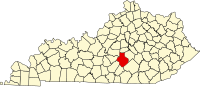 | |
| Unincorporated Communities | ||
| Ghost Towns | ||
This Casey County, Kentucky state location article is a stub. You can help Wikipedia by expanding it. |