Dysart, County Westmeath
Dysart
An Díseart | |
|---|---|
Village | |
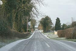
 The R391 passing through Dysart | |
| Coordinates: 53°28′20″N 7°27′32″W / 53.472218°N 7.458941°W | |
| Country | Ireland |
| Province | Leinster |
| County | County Westmeath |
| Time zone | UTC+0 (WET) |
| • Summer (DST) | UTC-1 (IST (WEST)) |
| Irish Grid Reference | N503438 |
Dysart (Irish: An Díseart, meaning "the hermitage")[1] is a village in County Westmeath, Ireland. It is located on the R391 road, to the west of Mullingar. Lough Ennell is located to the east.[2]
The town is located in the civil parish of the same name. A national school, two pubs and a 19th Century Catholic chapel[3] are located in the centre of the village.[4]
See also[edit]
References[edit]
- ^ "An Díseart/Dysart". Placenames Database of Ireland (logainm.ie). Retrieved 18 October 2021.
- ^ "Dysart (Westmeath) - Topographical Dictionary of Ireland (1837)". www.libraryireland.com. Retrieved 7 July 2020.
- ^ FUSIO. "Dysart Roman Catholic chapel, RATHNAMUDDAGH, County Westmeath". Buildings of Ireland. Retrieved 7 July 2020.
- ^ "Dysart: Records, maps and place-names". www.johngrenham.com. Retrieved 7 July 2020.


