
File:1743 GRAVESTONE - Church of St. Peter-in-the-Great Valley, Saint Peter's Road (East Whiteland Township), Devault, Chester County, PA HABS PA,15-DEV.V,3-4.tif

Size of this JPG preview of this TIF file: 433 × 600 pixels. Other resolutions: 173 × 240 pixels | 346 × 480 pixels | 554 × 768 pixels | 739 × 1,024 pixels | 1,479 × 2,048 pixels | 3,610 × 5,000 pixels.
Original file (3,610 × 5,000 pixels, file size: 17.22 MB, MIME type: image/tiff)
| This is a file from the Wikimedia Commons. Information from its description page there is shown below. Commons is a freely licensed media file repository. You can help. |
Summary
| 1743 GRAVESTONE - Church of St. Peter-in-the-Great Valley, Saint Peter's Road (East Whiteland Township), Devault, Chester County, PA | ||||
|---|---|---|---|---|
| Photographer |
Related names:
|
|||
| Title |
1743 GRAVESTONE - Church of St. Peter-in-the-Great Valley, Saint Peter's Road (East Whiteland Township), Devault, Chester County, PA |
|||
| Depicted place | Pennsylvania; Chester County; Devault | |||
| Date | Documentation compiled after 1933 | |||
| Dimensions | 5 x 7 in. | |||
| Current location |
Library of Congress Prints and Photographs Division Washington, D.C. 20540 USA http://hdl.loc.gov/loc.pnp/pp.print |
|||
| Accession number |
HABS PA,15-DEV.V,3-4 |
|||
| Credit line |
|
|||
| Notes |
|
|||
| Source | https://www.loc.gov/pictures/item/pa0266.photos.131986p | |||
| Permission (Reusing this file) |
|
|||

| Object location | | View this and other nearby images on: OpenStreetMap |
|---|
File history
Click on a date/time to view the file as it appeared at that time.
| Date/Time | Thumbnail | Dimensions | User | Comment | |
|---|---|---|---|---|---|
| current | 16:55, 2 August 2014 | 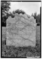 | 3,610 × 5,000 (17.22 MB) | Fæ | GWToolset: Creating mediafile for Fæ. HABS 2014-08-01 2601-2900 missing |
File usage
The following pages on the English Wikipedia use this file (pages on other projects are not listed):