
File:BROOKS ISLAND IN FOREGROUND AND FORD ASSEMBLY PLANT IN BACKGROUND, N. - Rosie the Riveter National Historical Park, 1401 Marina Way South, Richmond, Contra Costa County, CA HAER CA-326-32.tif

Size of this JPG preview of this TIF file: 432 × 599 pixels. Other resolutions: 173 × 240 pixels | 346 × 480 pixels | 554 × 768 pixels | 739 × 1,024 pixels | 1,477 × 2,048 pixels | 3,694 × 5,121 pixels.
Original file (3,694 × 5,121 pixels, file size: 18.04 MB, MIME type: image/tiff)
| This is a file from the Wikimedia Commons. Information from its description page there is shown below. Commons is a freely licensed media file repository. You can help. |
Summary
| BROOKS ISLAND IN FOREGROUND AND FORD ASSEMBLY PLANT IN BACKGROUND, N. - Rosie the Riveter National Historical Park, 1401 Marina Way South, Richmond, Contra Costa County, CA | ||||
|---|---|---|---|---|
| Photographer |
Lowe, Jet Related names:
|
|||
| Title |
BROOKS ISLAND IN FOREGROUND AND FORD ASSEMBLY PLANT IN BACKGROUND, N. - Rosie the Riveter National Historical Park, 1401 Marina Way South, Richmond, Contra Costa County, CA |
|||
| Depicted place | California; Contra Costa County; Richmond | |||
| Date | 2004 | |||
| Dimensions | 5 x 7 in. | |||
| Current location |
Library of Congress Prints and Photographs Division Washington, D.C. 20540 USA http://hdl.loc.gov/loc.pnp/pp.print |
|||
| Accession number |
HAER CA-326-32 |
|||
| Credit line |
|
|||
| Notes |
|
|||
| Source | https://www.loc.gov/pictures/item/ca3328.photos.194812p | |||
| Permission (Reusing this file) |
|
|||

| Object location | | View this and other nearby images on: OpenStreetMap |
|---|
File history
Click on a date/time to view the file as it appeared at that time.
| Date/Time | Thumbnail | Dimensions | User | Comment | |
|---|---|---|---|---|---|
| current | 05:33, 7 July 2014 | 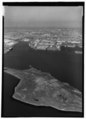 | 3,694 × 5,121 (18.04 MB) | Fæ | GWToolset: Creating mediafile for Fæ. HABS 05 July 2014 (501:600) |
File usage
The following pages on the English Wikipedia use this file (pages on other projects are not listed):