
File:DETAIL OF ARCH AND PEDIMENT OF WEST FACADE - Dubuque County Courthouse, 720 Central Avenue, Dubuque, Dubuque County, IA HABS IOWA,31-DUBU,5-6.tif

Size of this JPG preview of this TIF file: 429 × 599 pixels. Other resolutions: 172 × 240 pixels | 344 × 480 pixels | 550 × 768 pixels | 733 × 1,024 pixels | 1,467 × 2,048 pixels | 3,581 × 5,000 pixels.
Original file (3,581 × 5,000 pixels, file size: 17.08 MB, MIME type: image/tiff)
| This is a file from the Wikimedia Commons. Information from its description page there is shown below. Commons is a freely licensed media file repository. You can help. |
Summary
| DETAIL OF ARCH AND PEDIMENT OF WEST FACADE - Dubuque County Courthouse, 720 Central Avenue, Dubuque, Dubuque County, IA | ||||
|---|---|---|---|---|
| Photographer |
Related names:
|
|||
| Title |
DETAIL OF ARCH AND PEDIMENT OF WEST FACADE - Dubuque County Courthouse, 720 Central Avenue, Dubuque, Dubuque County, IA |
|||
| Depicted place | Iowa; Dubuque County; Dubuque | |||
| Date | Documentation compiled after 1933 | |||
| Dimensions | height: 7 in (17.7 cm); width: 5 in (12.7 cm) | |||
| Current location |
Library of Congress Prints and Photographs Division Washington, D.C. 20540 USA http://hdl.loc.gov/loc.pnp/pp.print |
|||
| Accession number |
HABS IOWA,31-DUBU,5-6 |
|||
| Credit line |
|
|||
| Notes |
|
|||
| Source | https://www.loc.gov/pictures/item/ia0129.photos.067714p | |||
| Permission (Reusing this file) |
|
|||

| Object location | | View this and other nearby images on: OpenStreetMap |
|---|
File history
Click on a date/time to view the file as it appeared at that time.
| Date/Time | Thumbnail | Dimensions | User | Comment | |
|---|---|---|---|---|---|
| current | 14:24, 13 July 2014 | 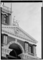 | 3,581 × 5,000 (17.08 MB) | Fæ | GWToolset: Creating mediafile for Fæ. HABS 11 July 2014 (1001:1200) |
File usage
The following pages on the English Wikipedia use this file (pages on other projects are not listed):