
File:Historic American Buildings Survey Richard Koch, Photographer, August, 1934 FRONT (SOUTHEAST ELEVATION) - 1436 Pauger Street (Cottage), New Orleans, Orleans Parish, LA HABS LA,36-NEWOR,12-1.tif

Size of this JPG preview of this TIF file: 755 × 600 pixels. Other resolutions: 302 × 240 pixels | 604 × 480 pixels | 967 × 768 pixels | 1,280 × 1,017 pixels | 2,560 × 2,034 pixels | 5,000 × 3,973 pixels.
Original file (5,000 × 3,973 pixels, file size: 18.95 MB, MIME type: image/tiff)
| This is a file from the Wikimedia Commons. Information from its description page there is shown below. Commons is a freely licensed media file repository. You can help. |
Summary
| Historic American Buildings Survey Richard Koch, Photographer, August, 1934 FRONT (SOUTHEAST ELEVATION) - 1436 Pauger Street (Cottage), New Orleans, Orleans Parish, LA | ||||
|---|---|---|---|---|
| Title |
Historic American Buildings Survey Richard Koch, Photographer, August, 1934 FRONT (SOUTHEAST ELEVATION) - 1436 Pauger Street (Cottage), New Orleans, Orleans Parish, LA |
|||
| Description |
de Marigny, Marquis |
|||
| Depicted place | Louisiana; Orleans Parish; New Orleans | |||
| Date | Documentation compiled after 1933 | |||
| Dimensions | 4 x 5 in. | |||
| Current location |
Library of Congress Prints and Photographs Division Washington, D.C. 20540 USA http://hdl.loc.gov/loc.pnp/pp.print |
|||
| Accession number |
HABS LA,36-NEWOR,12-1 |
|||
| Credit line |
|
|||
| Notes |
|
|||
| Source | https://www.loc.gov/pictures/item/la0017.photos.072710p | |||
| Permission (Reusing this file) |
|
|||

File history
Click on a date/time to view the file as it appeared at that time.
| Date/Time | Thumbnail | Dimensions | User | Comment | |
|---|---|---|---|---|---|
| current | 15:11, 20 July 2014 | 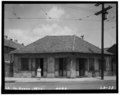 | 5,000 × 3,973 (18.95 MB) | Fæ | GWToolset: Creating mediafile for Fæ. HABS 16 July 2014 (1201:1400) |
File usage
The following pages on the English Wikipedia use this file (pages on other projects are not listed):