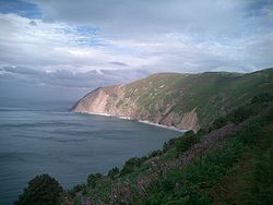
Foreland Point
This article needs additional citations for verification. (February 2013) |

Foreland Point is a rocky headland in Devon near Lynmouth, and is the most northerly point along the Devon and Exmoor coast.[1] The highest cliff is 89 metres (292 ft) above the high tide, although the highest point of the entire headland is near Countisbury (a village around a mile away) at 302 metres (991 ft). The headland is owned by the National Trust; some areas are open to public access all year, as part of the South West Coast Path, while other areas have limited access.[2] The Trinity House-operated Lynmouth Foreland Lighthouse is also located here.[3]
The area of the sea between Bideford and Foreland Point is a Marine Conservation Zone.[4]
References[edit]
- ^ . Encyclopædia Britannica (11th ed.). 1911.
- ^ "Walk - Foreland Point Adventurous Walk". South West Coast Path. Retrieved 27 September 2016.
- ^ "Lynmouth Foreland Lighthouse". Trinity House. Retrieved 27 September 2016.
- ^ "Marine Conservation Zones: Bideford to Foreland Point". Department for Environment, Food & Rural Affairs and Natural England and Joint Nature Conservation Committee. Retrieved 27 September 2016.
51°14′N 3°47′W / 51.233°N 3.783°W
