
Geibikei
| Geibikei | |
|---|---|
 typical panorama at Geibikei | |
 Location of Geibikei  Geibikei (Japan) | |
| Location | Ichinoseki, Iwate Prefecture, Japan |
| Coordinates | 38°59′24″N 141°15′4″E / 38.99000°N 141.25111°E |
| Length | 2 km (1.2 mi) |
Geibikei (猊鼻渓) is a ravine on the Satetsu River in the city of Ichinoseki, Iwate Prefecture, Japan. It has been designated a National Place of Scenic Beauty and Natural Monument since 1923.[1] In 1927 it was also selected as one of the 100 Landscapes of Japan.[2]
Overview[edit]
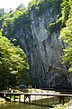
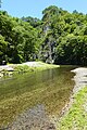
Geibikei is located in southern Iwate Prefecture, and is approximately two kilometers long. The river is surrounded by soaring cliffs of over 50 meters in height, and peaking at 124 meters, with fanciful rock formations created by erosion and numerous waterfalls. The name “Geibi,” which means “lion nose,” comes from a limestone formation near the end of the ravine which resembles a lion's snout. Unlike the Genbikei ravine, which is also located in Ichinoseki, the Geibikei is wide enough to permit use of small boats, and thus the ravine is noted for its 90-minute boat trip up and back down the river pushed along with a pole by boatmen, who sing on the return leg of the journey.
Before the Meiji period, the ravine was unknown, and the surrounding area was regarded as a near-wilderness. It was popularized by two local politicians, who invited numerous literary and political figures, including members of the aristocracy to visit the area.
Geibikei is a short walk from Geibikei Station on the JR East Ofunato Line.
Gallery[edit]
-
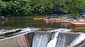 Geibikei boat dock
 -
 Panorama
 -
 Panorama
 -
 Panorama


See also[edit]
References[edit]
- ^ "猊鼻渓". Agency for Cultural Affairs. Retrieved 10 April 2020.
- ^ "日本八景(昭和2年)の選定内容" (PDF). Ministry of the Environment. Retrieved 10 February 2012.
External links[edit]
 Media related to Geibikei at Wikimedia Commons
- Iwate Prefecture tourist information
- Tohoku official tourist information
- Japan Travel website
This Iwate Prefecture location article is a stub. You can help Wikipedia by expanding it. |