
Geriş, Bodrum
Geriş | |
|---|---|
.jpg) A view of hillside houses in Geriş | |
 Geriş Location in Turkey  Geriş Geriş (Turkey Aegean) | |
| Coordinates: 37°05′N 27°17′E / 37.08°N 27.28°E | |
| Country | Turkey |
| Province | Muğla |
| District | Bodrum |
| Elevation | 165 m (541 ft) |
| Population (2023) | 3,863 |
| Time zone | UTC+3 (TRT) |
| Postal code | 48990 |
| Area code | 0252 |
Geriş is a neighbourhood of the municipality and district of Bodrum, Muğla Province, Turkey. It is located betqeen the neighbourhoods of Yalıkavak in the southwest and Koyunbaba in the northeast, on a bay at the Aegean Sea. As of 2023, its population is 3,863.[1] Before the 2013 Turkish local government reorganisation, it had avillage.[2]
On two hills above Geriş, about 3 km (1.9 mi) southwest of[Yalıkavak, there are ruins of a settlement, thought to be called Uranion, of the ancient people Leleges. Ruins of a mausoleum, walls and bastions can be seen on the coastal hill, and ruins of city walls can be seen on the other hill.[3]
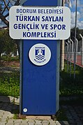
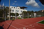
The women's handball club Yalıkavak SK, which play in the Turkish Women's Handball Super League and compete at European level, is based at Türkan Saylan Sports Complex in Geriş.[4]
Gallery[edit]
-
 Place name sign of Geriş
 -
 Türkan Saylan Sports Complex
 -
 Club office of Yalıkavak SK at the Türkan Saylan Sports Complex
 -
 Football field at the Türkan Saylan Sports Complex
 -
 Sports hall at the Türkan Saylan Sports Complex
.jpg)
.jpg)
.jpg)
.jpg)
.jpg)
References[edit]
- ^ "Muğla Bodrum Geriş Mahallesi Nüfusu" (in Turkish). Türkiye Nüfusu İl İlçe Mahalle Köy Nüfusları. Retrieved 19 March 2024.
- ^ "Law No. 6360". Official Gazette (in Turkish). 6 December 2012.
- ^ "Bodrum Yarımadası Antik Yerleşimleri" (in Turkish). Muğla Kültür ve Turizm İl Müdürlüğü. Retrieved 19 March 2024.
- ^ "Yalıkavak Spor Kulübü" (in Turkish). Türkiye Hentbol Federasyonu. Retrieved 20 March 2024.
This geographical article about a location in Muğla Province, Turkey is a stub. You can help Wikipedia by expanding it. |