Hawqa
Hawqa
حوقا | |
|---|---|
City | |
| Coordinates: 34°16′20″N 35°56′30″E / 34.27222°N 35.94167°E | |
| Country | |
| Governorate | North Governorate |
| District | Zgharta District |
| Elevation | 1,300 m (4,300 ft) |
| Time zone | UTC+2 (EET) |
| • Summer (DST) | UTC+3 (EEST) |
| Dialing code | +961 |
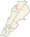
Hawqa ( known also as Haouqa or Hawka, Arabic: حوقا ) is a village in the Zgharta District in the North Governorate of Lebanon. It is in the valley of Qozhaya, the northern branch of the Valley of Qadisha.
External links[edit]


