
Hulsberg
Hulsberg
Hölsberg | |
|---|---|
Village | |
 Church of Hulsberg | |
 Hulsberg Location in the Netherlands  Hulsberg Location in the province of Limburg in the Netherlands | |
| Coordinates: 50°53′18″N 5°51′19″E / 50.88833°N 5.85528°E | |
| Country | Netherlands |
| Province | Limburg |
| Municipality | Beekdaelen |
| Area | |
| • Total | 3.52 km2 (1.36 sq mi) |
| Elevation | 132 m (433 ft) |
| Population (2021)[1] | |
| • Total | 3,180 |
| • Density | 900/km2 (2,300/sq mi) |
| Time zone | UTC+1 (CET) |
| • Summer (DST) | UTC+2 (CEST) |
| Postal code | 6336[1] |
| Dialing code | 045 |
Hulsberg (Dutch pronunciation: [ˈɦʏlzbɛr(ə)x]; Limburgish: Hölsberg) is a village in the southeastern Netherlands. It is located in the municipality of Beekdaelen, Limburg, about 15 km east of Maastricht.
History[edit]
The village was first mentioned in 1147 as Huleberga, and means "hill of holly (Ilex aquifolium)".[3] The area around Hulsberg was donated to the Abbey of Saint-Remi in 968.[4] Hulsberg is a village with a dries (type of village square).[5]
The Catholic St Clemens Church is a three aisled church from 1820. In 1908, Joseph Cuypers designed a new choir. The remainder was redesigned in 1930.[5]
Hulsberg was home to 332 people in 1840.[4] Until 1982, Hulsberg was a municipality of its own. After the re-arrangement of the municipalities in the Netherlands, Hulsberg and Schimmert were merged with the municipality of Nuth. In 2019, Nuth merged into Beekdaelen.[4]
Hulsberg is popular stay-over place for Dutch. Its accommodations include two campings, and several hotels and motels). Hulsberg is only 3 kilometres from Valkenburg aan de Geul with several tourist attractions.
Hulsberg is the namesake of a radio mast, Zendmast Hulsberg, which is located in the territory of Valkenburg aan de Geul.
Gallery[edit]
-
 Monastery
 -
 Community house
 -
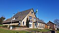
 School in Hulsberg
 -
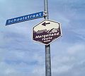 Mergellandroute sign in Hulsberg


Notable people[edit]
- Peter Akkermans, archaeologist (born 1957)
- Tjarco Cuppens, racing cyclist (born 1976)
- Jan Gerard Kerkherdere, Latinist (1677–1738)
- Ada Kok, swimmer (born 1947)
- Johannes Herman Frederik Umbgrove, geologist (1899–1954)
References[edit]
- ^ a b c "Kerncijfers wijken en buurten 2021". Central Bureau of Statistics. Retrieved 23 April 2022.
- ^ "Postcodetool for 6336AA". Actueel Hoogtebestand Nederland (in Dutch). Het Waterschapshuis. Retrieved 23 April 2022.
- ^ "Hulsberg - (geografische naam)". Etymologiebank (in Dutch). Retrieved 23 April 2022.
- ^ a b c "Hulsberg". Plaatsengids (in Dutch). Retrieved 23 April 2022.
- ^ a b Sabine Broekhoven, & Ronald Stenvert (2003). Hulsberg (in Dutch). Zwolle: Waanders. ISBN 90 400 9623 6. Retrieved 23 April 2022.