
Jerome Township, Gove County, Kansas
Jerome Township | |
|---|---|
 Location in Gove County | |
| Coordinates: 38°47′09″N 100°29′04″W / 38.78583°N 100.48444°W | |
| Country | United States |
| State | Kansas |
| County | Gove |
| Area | |
| • Total | 142.96 sq mi (370.28 km2) |
| • Land | 142.96 sq mi (370.25 km2) |
| • Water | 0.01 sq mi (0.02 km2) 0.01% |
| Elevation | 2,585 ft (788 m) |
| Population (2000) | |
| • Total | 132 |
| • Density | 0.9/sq mi (0.4/km2) |
| GNIS feature ID | 0471397 |
Jerome Township is a township in Gove County, Kansas, USA. As of the 2000 census, its population was 132.
Geography[edit]
Jerome Township covers an area of 142.96 square miles (370.3 km2) and contains no incorporated settlements.
The streams of Cheyenne Creek and Plum Creek run through this township.
Transportation[edit]
Jerome Township contains three airports or landing strips: Beesley Farms Airport, Lundgren Hereford Ranch Airport and Tustin Airport.
References[edit]
External links[edit]
Municipalities and communities of Gove County, Kansas, United States | ||
|---|---|---|
| Cities | 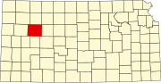 | |
| Ghost towns | ||
| Townships | ||
| Footnotes | ‡This community also has portions in an adjacent county or counties. | |
This article about a location in Gove County, Kansas is a stub. You can help Wikipedia by expanding it. |