Kentstown
Kentstown
Irish: Baile an Cheantaigh | |
|---|---|
Town | |
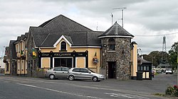
 Kentstown on the R150 | |
| Coordinates: 53°37′39″N 6°31′59″W / 53.62750°N 6.53306°W | |
| Country | Ireland |
| Province | Leinster |
| County | Meath |
| Elevation | 55 m (180 ft) |
| Population | 1,179 |
| Time zone | UTC+0 (WET) |
| • Summer (DST) | UTC-1 (IST (WEST)) |
| Irish Grid Reference | N970651 |
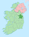
Kentstown (Irish: Baile an Cheantaigh)[2] is a village in County Meath in Ireland at the junction of the R153 and R150 regional roads.
History[edit]
The ruins of a medieval church can be found in Danestown, Kentstown,[3] while in the present St. Mary's Parish Church (Church of Ireland) an effigy in the shape of a medieval Norman knight is carved on a slab. The knight wears a tight-fitting jupon and has a dagger on his right hip. An inscription, in Latin, accompanies it: "Here lies Thomas de Tuite, Knight, once Lord of Kentstown, who died on 2nd June 1363".[4]
Demographics[edit]
In the 20 years between the 1996 and 2016 census, the population of Kentstown more than tripled from 324 to 1,179 inhabitants.[1][5] According to the 2016 census, 71% of the village's homes (252 of 353 households) were built between 1991 and 2010.[1]
Transport[edit]
Kentstown village is served by Bus Éireann route 105, which operates hourly in each direction providing links to Duleek, Drogheda and in the other direction to Ashbourne, Ratoath and Blanchardstown.[6] In addition, route 103X (Dublin-Ashbourne-Navan) provides a limited service of a morning journey to Dublin and an evening journey to Navan Mondays to Fridays inclusive.[7]
Nanny river[edit]
The Nanny rises outside of Kentstown, and flows about 18 miles to the Irish sea at Laytown.[8]
Notes[edit]
- ^ a b c "Sapmap Area - Settlements - Kentstown". Census 2016. Central Statistics Office. April 2016. Retrieved 16 February 2020.
- ^ "Baile an Cheantaigh/Kentstown". logainm.ie. Placenames Database of Ireland. Retrieved 15 October 2021.
- ^ "Meath County Council - Record of Protected Structures - County Development Plan 2007-2013 - Adopted 2nd March 2007" (PDF). Archived from the original (PDF) on 20 November 2007. Retrieved 27 August 2008.
- ^ "Historic Meath". octavehouse.com. Archived from the original on 28 July 2009. Retrieved 27 August 2008.
- ^ "Kentstown (Ireland) Census Town". City Population. Retrieved 16 February 2020.
- ^ "Route 105 Timetable" (PDF). buseireann.ie. Bus Éireann. Retrieved 15 October 2021.
- ^ "Route 103X Timetable" (PDF). buseireann.ie. Bus Éireann. Retrieved 15 October 2021.
- ^ O'Reilly, Peter (1 April 2003). Rivers of Ireland: A Flyfisher's Guide. Stackpole Books. p. 226.


