
Kersey, Pennsylvania
Kersey, Pennsylvania | |
|---|---|
 Kersey | |
| Coordinates: 41°21′44″N 78°35′46″W / 41.36222°N 78.59611°W | |
| Country | United States |
| State | Pennsylvania |
| County | Elk |
| Township | Fox |
| Area | |
| • Total | 1.55 sq mi (4.03 km2) |
| • Land | 1.55 sq mi (4.02 km2) |
| • Water | 0.00 sq mi (0.01 km2) |
| Elevation | 1,980 ft (600 m) |
| Population | |
| • Total | 797 |
| • Density | 513.20/sq mi (198.12/km2) |
| Time zone | UTC-5 (Eastern (EST)) |
| • Summer (DST) | UTC-4 (EDT) |
| ZIP code | 15846 |
| Area code | 814 |
| FIPS code | 42-39512 |
| GNIS feature ID | 1178412 |
Kersey is an unincorporated community and census-designated place in Fox Township, Elk County, Pennsylvania, United States. As of the 2020 census the population was 797.[3][4]
History[edit]
The first permanent settlers of the county arrived in 1810 and founded Centreville at the headwaters of Little Toby Creek. Later that year, William Kersey built a gristmill and/or sawmill there, and the settlement was renamed "Kersey", though early sources sometimes refer to it as "Kersey's".[5] At the time, the area was part of Clearfield County, as Elk County had not yet been formed. Early industries in the community were lumber and coal.[6]
Geography[edit]
Kersey is located in northern Fox Township, in south-central Elk County. Pennsylvania Route 948 passes through the community, leading east 2 miles (3 km) to PA 255 and west 5 miles (8 km) to U.S. Route 219, which leads 4 miles (6 km) north to Ridgway, the county seat.
According to the U.S. Census Bureau, the Kersey CDP has a total area of 1.56 square miles (4.04 km2), of which 1.49 acres (6,015 m2), or 0.15%, is water.[4] The CDP includes the community of Dagus, to the west of Kersey proper. The community of Dagus Mines borders the CDP to the south. Kersey sits at an elevation of 1,980 feet (600 m) above sea level, 1 mile (1.6 km) northwest of the Eastern Continental Divide.
Demographics[edit]
| Census | Pop. | Note | %± |
|---|---|---|---|
| 2020 | 797 | — | |
| U.S. Decennial Census[7] | |||
References[edit]
- ^ "ArcGIS REST Services Directory". United States Census Bureau. Retrieved October 12, 2022.
- ^ "Census Population API". United States Census Bureau. Retrieved October 12, 2022.
- ^ https://data.census.gov/table?q=Kersey+CDP;+Pennsylvania
- ^ a b "Geographic Identifiers: 2010 Demographic Profile Data (G001): Kersey CDP, Pennsylvania". American Factfinder. U.S. Census Bureau. Archived from the original on February 13, 2020. Retrieved March 14, 2016.
- ^ Leeson, Michael (1890). History of the Counties of McKean, Elk, and Forest, Pennsylvania, with Biographical Selections. J.H. Beers & Company. pp. 760–768. Retrieved August 24, 2019.
kersey's.
- ^ McGeehan, Dennis (2007). Images of America Elk County. Arcadia Publishing. pp. 7, 34. ISBN 978-0-7385-5479-2.
- ^ "Census of Population and Housing". Census.gov. Retrieved June 4, 2016.
Municipalities and communities of Elk County, Pennsylvania, United States | ||
|---|---|---|
| City | 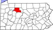 | |
| Boroughs | ||
| Townships | ||
| CDPs | ||
| Unincorporated communities | ||
| International | |
|---|---|
| National | |
This Elk County, Pennsylvania state location article is a stub. You can help Wikipedia by expanding it. |