
Kingsland Avenue Bridge (Passaic River)
Kingsland Avenue Bridge | |
|---|---|
 | |
| Coordinates | 40°48′40″N 74°08′19″W / 40.8110°N 74.1385°W |
| Carries | |
| Crosses | Passaic River |
| Locale | Nutley and Lyndhurst, New Jersey |
| Other name(s) | De Jessa Memorial Bridge Park Avenue Bridge Avondale Bridge |
| Maintained by | Bergen and Essex |
| ID number | 020032A |
| Characteristics | |
| Design | Swing bridge |
| Total length | 364 feet (111 m) |
| Width | 46 feet (14 m) |
| No. of spans | 3 |
| Clearance below | 7 feet (2.1 m) (high water) 12 feet (3.7 m) (low water) |
| History | |
| Designer | James Owen (Essex) H.M. Watson (Bergen) |
| Fabrication by | New Jersey Bridge Company F.M. Stillman Company |
| Construction start | 1903 |
| Opened | 1905 1986 reconstructed |
| Location | |
 | |
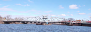
Kingsland Avenue Bridge, earlier known as Avondale Bridge and designated the De Jessa Memorial Bridge, is a vehicular movable bridge over the Passaic River in northeastern New Jersey. It crosses the county line to connect the towns of Lyndhurst in Bergen and Nutley in Essex,[1] originally taking its name from the Kingsland section. The bridge is 10.7 miles (17.2 km) from the river's mouth at Newark Bay, and is required to open on four hours' notice.[2] As of 2010, there were 26,420 daily crossings of the bridge, which provides one lane in each direction.[3]
History[edit]
Designed as a joint project between the two counties and built 1903-1905 by the New Jersey Bridge Company, it has a rim-bearing hybrid (pinned/riveted) Warren through truss swing span supported on an ashlar substructure and Warren pony truss approach spans. Rededicated July 14, 1981, in memory of Joseph Carmine De Jessa,[4] a U.S. Marine and the first Lyndhurst native killed in the Vietnam War, the bridge was significantly rehabilitated in 1984.[5][6]
Planned reconstruction/replacement[edit]
The bridge is considered functionally obsolete, meaning that it can no longer handle the traffic demands made upon it when considering such factors as load carrying capacity, vertical, clearance, alignment, and deck geometry. Bergen and Essex have requested that the bridge be re-built by the NJDOT and are acquiring land for a widening of right-of way along approach roads to it. The scope of work could be as extensive as that of the Court Street Bridge on the Hackensack completed in 2012.[3] As of 2014 roadworks in the vicinity of the bridge were under way, but no funding for its repair or replacement had been identified.[7][8]
In December 2014 the North Jersey Transportation Planning Authority (NJTPA) recommended funding for the concept development for the replacement of the bridge.[9][10][11] In September 2015, NJTPA put out a request for proposals to begin the process.[12][13][14][15][16] As of 2020 NJTPA reported it as a development project.[17]
See also[edit]
- Lyndhurst Draw
- List of crossings of the Lower Passaic River
- List of crossings of the Upper Passaic River
References[edit]
- ^ "Local Concept Development Phase". Archived from the original on 2016-11-14. Retrieved 2016-11-13.
- ^ "Section 117.739 - Passaic River" (PDF). Code of Federal Regulations Title 33 - Navigation and Navigable Waters Volume: 1. Government Publishing Office. July 1, 2002. Retrieved 2012-08-21.
- ^ a b Grant, Meeghan (December 6, 2012). "Lyndhurst's DeJessa, bridges showing their ages". The Record. Retrieved 2012-12-12.
- ^ "De Jessa Memorial Bridge". Old Nutley. Nutley Historical Society. Archived from the original on 2004-12-08. Retrieved 2012-08-21.
- ^ "Masonry and Metal The Historic Bridges of Bergen County, New Jersey" (PDF). Richard Grubb and Associates. 2008. Archived from the original (PDF) on 2012-07-10. Retrieved 2012-08-21.
- ^ "Park Avenue over Passaic River" (PDF). Historic Bridge Survey (1991-1994). New Jersey Department of Transportation. 2001. Retrieved 2012-08-21.
- ^ Joe Phalon (August 21, 2014). "Senate president visits Lyndhurst to jump-start Transportation Trust Fund". NorthJersey.com. Archived from the original on 2014-10-11. Retrieved 2016-01-14.
- ^ Zachary Croce (November 6, 2014). "Construction begins at DeJessa Bridge intersection in Lyndhurst". NorthJersey.com. Archived from the original on November 12, 2014.
- ^ Hasime Kukaj (December 12, 2014). "Study may lead to Lyndhurst-Nutley bridge's replacement". NorthJersey.com. Archived from the original on December 26, 2014.
- ^ Melissa Hayes (December 8, 2014). "North Jersey transportation agency targets efforts to rebuild Bergen, Essex drawbridge". NorthJersey.com. Archived from the original on May 13, 2015.
- ^ Hasime Kukaj (January 12, 2015). "N.J. transportation board OKs Lyndhurst-Nutley bridge study". NorthJersey.com. Archived from the original on January 15, 2015.
- ^ Zachary Croce (September 10, 2015). "North Jersey Transportation Planning Authority seeking proposals for DeJessa Bridge study - Transportation". NorthJersey.com. Archived from the original on 2015-09-12.
- ^ "New Jersey Transportation Planning Authority — Request for Proposals — FY 2016 Bergen County and Essex County Local Concept Development Studies". New Jersey Transportation Planning Authority. August 27, 2015. Archived from the original on 2 February 2017. Retrieved 25 January 2017.
The structure was built in 1905 and reconstructed in 1986. It consists of a two-span, steel thru-truss swing span with two steel thru-truss approach spans having a total length of 364 feet and a total width of 45 feet and 8 inches. The bridge carries one eastbound and one westbound traffic lane, with one 6 foot pedestrian sidewalk in each direction. The bridge cartway (roadway width) is 27 feet and 2 inches.
- ^ "NJTPA 2016 Local Concept Development Study Bergen & Essex Counties Kingsland Avenue Bridge over the Passaic River".
- ^ "About the Project -".
- ^ "Nutley, New Jersey - Kingsland Avenue (De Jessa Memorial) Bridge Project". www.nutleynj.org.
- ^ Kingsland Avenue, Bridge over Passaic River (PDF). FY 2020 Study and Development Program (Report). North Jersey Transportation Planning Authority. 2019. Archived from the original (PDF) on October 20, 2020.
The existing bridge is a twin six-span, simply supported structure with a total length of 302'-2". The total width of the bridge is 74'-0". The bridge was constructed in 1971 and carries four (4) 12-foot lanes between curbs bounded by 5-foot wide sidewalks on both sides. The bridge has a 10' wide medium which contains a 5' wide utility bank between the two structures providing for separate eastbound and westbound roadways. The bridge replaced an existing swing span structure. The superstructure consists of 11 adjacent prestressed concrete box beams overlaid with an asphalt wearing course. There is cracking in the grout joints between the adjacent units resulting in reflective cracks in the wearing surface, eventually causing corrosion of the non-prestressed and prestressed reinforcement. The bridge has a sufficiency rating of 23.0.
External links[edit]
Crossings of the Passaic River | ||||
|---|---|---|---|---|
| ||||
- Bridges over the Passaic River
- Swing bridges in the United States
- Lyndhurst, New Jersey
- Nutley, New Jersey
- Bridges in Essex County, New Jersey
- Bridges in Bergen County, New Jersey
- Bridges completed in 1905
- Road bridges in New Jersey
- Steel bridges in the United States
- Warren truss bridges in the United States
- 1905 establishments in New Jersey