
Kirumampakkam
Kirumampakkam | |
|---|---|
Village | |
 Kirumampakkam Location in Puducherry, India  Kirumampakkam Kirumampakkam (India) | |
| Coordinates: 11°49′13″N 79°47′09″E / 11.820204°N 79.785891°E | |
| Country | |
| State | Puducherry |
| District | Pondicherry |
| Taluk | Bahour |
| Commune | Bahour |
| Languages | |
| • Official | French, Tamil, English |
| Time zone | UTC+5:30 (IST) |
| PIN | 607 402 |
| Telephone code | 0413 |
| Vehicle registration | PY-01 |
| Sex ratio | 50% ♂/♀ |
Kirumampakkam is a village[1] in Bahour Commune of Bahour taluk in the Union Territory of Puducherry, India. It lies on Cuddalore road (NH-45A) at a distance of 15 km from Pondicherry.
Geography[edit]
Kirumampakkam is bordered by Nagappanur village of Tamil nadu in the west, Madalapattu village of Tamil nadu in the north, Pannithittu in east and Pillaiyarkuppam in the south.
Road Network[edit]
Kirumampakkam is connected to Puducherry by Cuddalore road (NH-45A). Also Kirumampakkam-Bahour road (RC-27) connects Kirumampakkam with Bahour, its Commune Headquarters. Kirumampakkam provides gateway to Nagappanur village of Tamil nadu.
Gallery[edit]
-
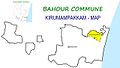 Map of Kirumampakkam Village Panchayat
 -
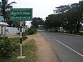 Kirumambakkam, Bahour Commune
 -
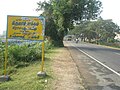 Welcome to Kirumambakkam Village Panchayat, Bahour Commune


Politics[edit]
Kirumampakkam is a part of Embalam (Union Territory Assembly constituency) which comes under Puducherry (Lok Sabha constituency)
References[edit]
- ^ "Archived copy" (PDF). Archived from the original (PDF) on 27 September 2013. Retrieved 17 March 2013.
{{cite web}}: CS1 maint: archived copy as title (link)