
Kyle Rhea
| Kyle Rhea | |
|---|---|
.jpg) The ferry MV Glenachulish on Kyle Rhea, beside Kylerhea pier. This view is looking north | |
 Location of Kyle Rhea | |
| Location | |
| Country | Scotland |
| County | Highlands |
| Physical characteristics | |
| Source | |
| • coordinates | 57°10′47″N 5°42′06″W / 57.179613°N 5.701599°W |
| Mouth | |
• coordinates | 57°15′17″N 5°38′28″W / 57.254828°N 5.641010°W |
| Length | 6.0 mi (9.7 km) |
Kyle Rhea is a strait of water in the Highland area of Scotland. It runs from the Inner Seas off the West Coast of Scotland in the southwest to Loch Alsh in the northeast, separating the Isle of Skye from Inverness-shire on the Scottish mainland.[1][2] It gave its name to Kylerhea, a village on its western shore.
Loch Hourn branches off to the east at about its midpoint.
Just north of Kylerhea, a ferry service has linked the village with Glenelg on the mainland for centuries. The first car ferry[3] was introduced in 1935, with a turntable located on the boat. Despite the existence of the now toll-free Skye Bridge, this ferry service, undertaken by the MV Glenachulish, still runs during the summer months, due to its popularity as the more scenic and traditional route between Skye and the mainland. This service is now community-owned but used to be run by Murdo Mackenzie for almost twenty years.[4]
Kyle Rhea is mentioned in Sir Thomas Dick Lauder's novel Highland Legends.[5]
Gallery[edit]
-
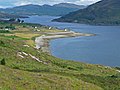 Looking north along the strait towards Kylerhea and Loch Alsh

References[edit]
- ^ The Kyle Rhea Tidal Stream Array: Volume I, Non-Technical Summary – SeaGeneration (Kyle Rhea) Ltd.
- ^ Gazetteer of the British Isles, John Bartholomew (1887), p. 462
- ^ The Original Glenelg-Skye Ferry – SkyeFerry.co.uk
- ^ "On board the world's last surviving turntable ferry". BBC News. Retrieved 2 May 2023.
- ^ Highland Legends, Sir Thomas Dick Lauder (1880), p. 179
External links[edit]
- Kyle Rhea – Scottish-Places.info
- 19th-century map of Kyle Rhea – National Library of Scotland
This Scottish location article is a stub. You can help Wikipedia by expanding it. |