Lemselo
Lemselo | |
|---|---|
Hamlet | |
 Farm in Lemselo | |
| Nickname: Heuimiegers | |
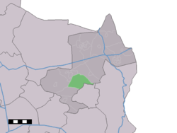
 Lemselo in the municipality of Dinkelland. | |
| Coordinates: 52°20′11″N 6°53′44″E / 52.33639°N 6.89556°E | |
| Country | Netherlands |
| Province | Overijssel |
| Municipality | Dinkelland |
| Elevation | 17 m (56 ft) |
| Demonym | Lemseloërs |
| Time zone | UTC+1 (CET) |
| • Summer (DST) | UTC+2 (CEST) |
| Postal code | 7595 |
| Dialing code | 0541 |
Lemselo is a hamlet in the Dutch province of Overijssel. It is a part of the municipality of Dinkelland, and lies about 3 km northwest of Oldenzaal.
Lemselo is not a statistical entity,[2] and the postal authorities have placed it under Weerselo.[3] It was first mentioned in the late-10th century as Lamesloe, and means "forest of Lam (person)".[4] Despite its size, it is not marked with place name signs. In 1840, it was home to 402 people. Nowadays, it contains about 180 houses.[5]
Notable[edit]
- Gerard Veldscholten (born 1959), former professional road bicycle racer[6]
References[edit]
- ^ "Postcodetool for 7595AA". Actueel Hoogtebestand Nederland (in Dutch). Het Waterschapshuis. Retrieved 15 March 2022.
- ^ "Kerncijfers wijken en buurten 2021". Central Bureau of Statistics. Retrieved 15 March 2022.
- ^ "Postcode 7595 in Weerselo". Postcode bij adres (in Dutch). Retrieved 15 March 2022.
- ^ "Lemselo". Etymologiebank (in Dutch). Retrieved 15 March 2022.
- ^ "Lemselo". Plaatsengids (in Dutch). Retrieved 15 March 2022.
- ^ "Gerard Veldscholten". Wie is Wie in Overijssel (in Dutch). Retrieved 15 March 2022.


