
Llanwrin
| Llanwrin | |
|---|---|
 Llanwrin in 2006 | |
 Llanwrin Location within Powys | |
| OS grid reference | SH787034 |
| Principal area | |
| Preserved county | |
| Country | Wales |
| Sovereign state | United Kingdom |
| Post town | MACHYNLLETH |
| Postcode district | SY20 |
| Dialling code | 01650 |
| Police | Dyfed-Powys |
| Fire | Mid and West Wales |
| Ambulance | Welsh |
| UK Parliament | |
Llanwrin (ⓘ) is a small village in the valley of the Afon Dyfi in Powys, Wales, about two miles north-east of Machynlleth.
History and background[edit]
Historically, it was in the county of Montgomeryshire (Welsh: Sir Drefaldwyn).
The village is named after its church, dedicated to St. Gwrin, which dates from late medieval times and was last restored in 1864.[1] The nearby historically significant house of Mathafarn dates back to at least 1485.
Once a thriving community with its own blacksmith, pub and village shop – all long since closed – in recent years the village has been a collection of houses stretched along the B4404 road.
Straw man[edit]
Llanwrin is known locally for its various straw man characters, which are located from time to time on the small triangle-shaped village green.
-
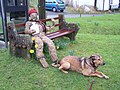 The Strawman
 -
 Church of St Ust and St Dyfrig


References[edit]
External links[edit]
- Photos of Llanwrin and surrounding area on geograph
- Eco Dyfi Valley Partnership
- Genealogical information about Llanwrin
- Map of Llanwrin in 1837

This Powys location article is a stub. You can help Wikipedia by expanding it. |