Marmaton, Kansas
Marmaton, Kansas | |
|---|---|
 | |
| Coordinates: 37°49′55″N 94°49′29″W / 37.83194°N 94.82472°W[1] | |
| Country | United States |
| State | Kansas |
| County | Bourbon |
| Township | Marmaton |
| Incorporated | 1858 |
| Elevation | 853 ft (260 m) |
| Time zone | UTC-6 (CST) |
| • Summer (DST) | UTC-5 (CDT) |
| Area code | 620 |
| FIPS code | 20-44875 |
| GNIS ID | 474764[1] |
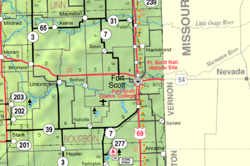
Marmaton is an unincorporated community in Bourbon County, Kansas, United States.[1] The community is located three miles east of Redfield, and two miles south of U.S. Route 54, at the intersection of 155th Street and Limestone Road.
History[edit]
Marmaton was incorporated in 1858. It was named for the Marmaton River, which crosses the township. Marmaton is a corruption of Marmiton, a French name given by fur traders meaning "scullion".[2]
The mailing address for residents of Marmaton is Fort Scott, Kansas.
References[edit]
- ^ a b c d U.S. Geological Survey Geographic Names Information System: Marmaton, Kansas
- ^ Robley, T. F. (1894). History of Bourbon County, Kansas: To the Close of 1865. Press of the Monitor book & printing Company. pp. 98.
Further reading[edit]
External links[edit]

