
Marttila
Marttila
S:t Mårtens | |
|---|---|
Municipality | |
| Marttilan kunta S:t Mårtens kommun | |
_-_panoramio.jpg) A countryside of Marttila | |
 Coat of arms | |
 Location of Marttila in Finland | |
| Coordinates: 60°35′N 022°54′E / 60.583°N 22.900°E | |
| Country | |
| Region | Southwest Finland |
| Sub-region | Loimaa sub-region |
| Charter | 1409 |
| Named for | Martin of Tours |
| Government | |
| • Municipal manager | Anne Ahtiainen |
| Area (2018-01-01)[1] | |
| • Total | 195.99 km2 (75.67 sq mi) |
| • Land | 195.31 km2 (75.41 sq mi) |
| • Water | 0.71 km2 (0.27 sq mi) |
| • Rank | 264th largest in Finland |
| Population (2023-12-31)[2] | |
| • Total | 1,930 |
| • Rank | 260th largest in Finland |
| • Density | 9.88/km2 (25.6/sq mi) |
| Population by native language | |
| • Finnish | 95.6% (official) |
| • Swedish | 1% |
| • Others | 3.4% |
| Population by age | |
| • 0 to 14 | 15.9% |
| • 15 to 64 | 56.3% |
| • 65 or older | 27.8% |
| Time zone | UTC+02:00 (EET) |
| • Summer (DST) | UTC+03:00 (EEST) |
| Climate | Dfc |
| Website | www.marttila.fi |
Marttila (Finnish: [ˈmɑrtːilɑ]; Swedish: S:t Mårtens, i.e. "Saint Martin's") is a municipality of Finland. It is located in the province of Western Finland and is part of the Southwest Finland region. The municipality has a population of 1,930 (31 December 2023)[5] and covers an area of 195.99 square kilometres (75.67 sq mi) of which 0.71 km2 (0.27 sq mi) is water.[1] The population density is 9.88 inhabitants per square kilometre (25.6/sq mi).
The municipality is unilingually Finnish.
Marttila's neighbouring municipalities are Koski Tl, Lieto, Loimaa, Paimio, Pöytyä and Salo.
History[edit]
During the Swedish domestic war regarding who was to be king, an important battle took place here 29 August 1599. Troops under Axel Kurck, supporting king Sigismund were defeated by troops supported duke Karl, soon to be king Karl IX. Karl more or less already ruled Sweden and what is Finland nowadays, and Sigismund were based in Poland. There is a memorial, erected 1934, to be seen in Marttila. Martilla is along what at that time was called "Tavastlands Oxväg", in Finnish now posted as "Hämeen Härkätie", which in English translates to "Oxroad of Häme".
Notable people[edit]
- Sirkka-Liisa Anttila (born 1943), politician; the former Minister of Agriculture and Forestry
- Lauri Heikkilä (born 1957), politician
- Simo Laaksonen (born 1998), racing driver
Gallery[edit]
-
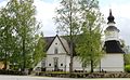 Church
 -
 Borough hall
 -
 Lainamakasiinit
 -
 Nuorisoseurantalo


References[edit]
- ^ a b "Area of Finnish Municipalities 1.1.2018" (PDF). National Land Survey of Finland. Retrieved 30 January 2018.
- ^ a b "Population growth biggest in nearly 70 years". Population structure. Statistics Finland. 2024-04-26. ISSN 1797-5395. Retrieved 2024-04-29.
- ^ "Population according to age (1-year) and sex by area and the regional division of each statistical reference year, 2003–2020". StatFin. Statistics Finland. Retrieved 2 May 2021.
- ^ a b "Luettelo kuntien ja seurakuntien tuloveroprosenteista vuonna 2023". Tax Administration of Finland. 14 November 2022. Retrieved 7 May 2023.
- ^ "Suomen virallinen tilasto (SVT): Väestön ennakkotilasto [verkkojulkaisu]" (in Finnish). Statistics Finland. Retrieved 15 March 2019.
External links[edit]
![]() Media related to Marttila at Wikimedia Commons
Media related to Marttila at Wikimedia Commons
![]() Marttila travel guide from Wikivoyage
Marttila travel guide from Wikivoyage

| International | |
|---|---|
| National | |
| Geographic | |
This Western Finland location article is a stub. You can help Wikipedia by expanding it. |