
Mary River (Nunavut)
Mary River is located on Baffin Island in the Qikiqtaaluk Region of Nunavut, about 936 km (582 mi) northwest of the capital, Iqaluit, and about 176 km (109 mi) southwest of Pond Inlet Inuktitut: Mittimatalik, lit. 'the place where the landing place is'[1] The Inuit, name for the Mary River mountain is Nuluyait, meaning buttocks.[2] There is a 4,000 year history in the area. For hundreds of years the semi-nomadic Inuit from the region that includes the hamlets of Pond Inlet and Igloolik, met at Mary River during the summer hunting caribou.[3] By 2011, the population of the region was about 5,400 people, many of whom continued the traditional hunting and fishing lifestyle living off the land.[3]
A Canadian prospector found rich iron ore deposits in 1962 but it was only in the 2010s that a mining project was developed.[3] In March 2011, a private equity fund in the United States and Luxembourg-based ArcelorMittal SA, the largest steel maker in the world, jointly purchased the small Toronto-based public Canadian company, Baffinland Iron Mines Corporation, that had owned the Mary River lease since the 1980s.[3] The Mary River open pit iron ore mine became operational in 2015.[4]
Traditional Inuit lands[edit]
There is a 4,000 year history in the area. For hundreds of years the semi-nomadic Inuit met at Mary River during the summer hunting caribou.[3] By 2011, there were about 5,400 people living within a 400 kilometres radius, many of whom continue to live off the land, hunting caribou herds. Wildlife in the region includes polar bears, foxes, ermines, lemmings, and hares, as well as caribou herds, and in the coastal waters—walrus, seals, beluga, whales, and narwhals.[3]
Mary River Mine[edit]
In 1962 Murray Edmund Watts and Ron Sheardown found a rich iron ore deposit. When Watts died a small Toronto-based company, Baffinland Iron Mines Corporation, became the new owners. In 2008 railway enthusiasts anticipated the construction of a railway in the far north to the proposed mine at Mary River.[5][6][7][8][9][10]
In March 2011, a private equity fund in the United States and Luxembourg-based ArcelorMittal SA, the largest steel maker in the world, jointly purchased the small Toronto-based public Canadian company, Baffinland Iron Mines Corporation, that had owned the Mary River lease since the 1980s.[3] The Mary River open pit iron ore mine became operational in 2015.[4]
There is a small airstrip, Mary River Aerodrome, located near the river.
-
 Mary River Aerodrome
 -
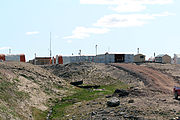
 Mary River mine site
 -
 Mary River mine site
 -
 Mary River mine site
 -
 Road to Mary River
 -
 Fresh water lake at Mary River
 -
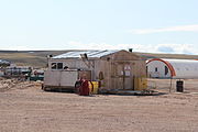
 Mary River camp

.jpg)

.jpg)


See also[edit]
References[edit]
- ^ Hamlet of Pond Inlet
- ^ George, Jane (November 7, 2011). "Draft EIS for Nunavut's Mary River mine sparks stinging technical review". Nunatsiaq News. Cambridge Bay, Nunavut. Retrieved February 5, 2021.
- ^ a b c d e f g Waldie, Paul (May 14, 2011). "A railway to Arctic riches: economic boom, environmental threat?". The Globe And Mail. Retrieved February 5, 2021.
- ^ a b Tranter, Emma (January 31, 2021). "'Serious concern' among Nunavut communities over iron ore mine's proposed expansion". CTVNews. Retrieved February 5, 2021.
- ^ "Arctic iron ore line proposed". Railway Gazette International. 2006-07-01. Archived from the original on 2009-05-01. Retrieved 2009-05-01.
- ^ "Baffinland Announces New Members of the Baffinland Team to Advance its World Class Iron Ore Project". Mining Top News. 2007-04-10. Archived from the original on 2009-05-17.
- ^ "Baffin Island arctic ore line advances". Railway Gazette International. 2008-04-25. Archived from the original on 2009-05-01. Retrieved 2008-08-10.
{{cite magazine}}: Cite magazine requires|magazine=(help) - ^ Carolyn Fitzpatrick (2008-07-24). "Heavy haul in the high north". Railway Gazette International. Archived from the original on 2009-05-01. Retrieved 2008-08-10.
{{cite magazine}}: Cite magazine requires|magazine=(help) - ^ "Baffin Island Iron". Arctic Economics. 2008-07-28. Archived from the original on 2009-05-08.
- ^ David K. Joy. "Mary River Iron Project". Archived from the original on 2009-05-03.
71°10′59″N 079°21′00″W / 71.18306°N 79.35000°W
This Qikiqtaaluk Region, Nunavut location article is a stub. You can help Wikipedia by expanding it. |