
Mont Soleil
| Mont Soleil | |
|---|---|
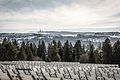
 View near the summit | |
| Highest point | |
| Elevation | 1,291 m (4,236 ft) |
| Prominence | 221 m (725 ft)[1] |
| Parent peak | Mont Racine |
| Coordinates | 47°09′55″N 6°59′20″E / 47.16528°N 6.98889°E |
| Geography | |
 Mont Soleil Location in Switzerland | |
| Location | Bern, Switzerland |
| Parent range | Jura Mountains |
Mont Soleil is a mountain of the Jura Mountains, located north of Saint-Imier in the canton of Bern, Switzerland. The summit reaches to 1,291 metres (4,236 ft) and the area can be easily accessed with Funiculaire Saint-Imier-Mont-Soleil, a funicular from Saint-Imier, reaching a height of 1,180 m (3,870 ft).
An observatory is located on the summit as well as several wind turbines and a solar park: the former with their presence, the highest is 150 m (490 ft) high, and noise introduced an element of disturbance in the landscape.[2]
Gallery[edit]
-
 View of Chasseral from the solar park
 -
 View of the summit with a wind turbine
 -
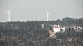 View of the summit with the wind turbines
 -
 Astronomical Observatory
 -
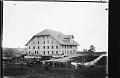
 Pension des Eloyes
 -
 View of Saint Imier and Mont Soleil
 -
 House Peter Widmer


See also[edit]
References[edit]
- ^ Retrieved from the Swisstopo topographic maps. The key col is located north of Les Convers at 1,070 metres.
- ^ Neuenschwander, Pia (31 August 2014). "Im Berner Jura auf dem Mont Crosin befindet sich der älteste und grösste Windpark der Schweiz" [In the Jura Mountains on Mount Crosin one finds the oldest and largest Windpark of Switzerland] (in German). Horizonte Aargau. "Er dreht, dreht, weht der Wind". Retrieved 18 September 2015.
External links[edit]
Wikimedia Commons has media related to Mont-Soleil.
This Canton of Bern location article is a stub. You can help Wikipedia by expanding it. |