
Nova Scotia Highway 107
Highway 107 | ||||
|---|---|---|---|---|
 | ||||
| Route information | ||||
| Maintained by Nova Scotia Department of Public Works | ||||
| Length | 43.2 km[1] (26.8 mi) | |||
| Existed | 1975–present | |||
| Major junctions | ||||
| West end | (future) | |||
| Akerley Boulevard in Dartmouth | ||||
| East end | ||||
| Location | ||||
| Country | Canada | |||
| Province | Nova Scotia | |||
| Highway system | ||||
| ||||


Highway 107 in Nova Scotia runs through the eastern suburbs of the Halifax Regional Municipality, from the Burnside Industrial Park in Dartmouth to an intersection with Trunk 7 in Musquodoboit Harbour. It is 43.2 km (26.8 mi) long, and is mostly two lane, controlled access highway.
Route description[edit]
From its current western terminus at the intersection of Akerley Boulevard and Burnside Drive in Burnside,[1] Highway 107 travels northeast to its interchange with Highway 118, then continues southeast on the Forest Hills Extension to an intersection of Main Street in Dartmouth and Trunk 7 in Westphal. The highway then travels east, concurrent with Trunk 7, through the Sunset Acres neighbourhood in Westphal and the community of Cherry Brook for about 5 km (3.1 mi). Near Preston, Highway 107 and Trunk 7 split, and Highway 107 continues eastward as a controlled access two-lane highway for the remainder of its route. The highway travels past the communities of Preston, Lake Echo, Porters Lake and Head of Chezzetcook before reaching its eastern terminus with Trunk 7 west of Musquodoboit Harbour.
History[edit]
Dartmouth to Musquodoboit Harbour section[edit]
Construction of the highway began in 1972/73.[2] The first segment, running from Trunk 7 to Mineville Road, opened to traffic during the 1975/76 fiscal year. At that time a further extension of the road, across Lake Echo, was under construction.[3]
Grading work for the final segment from Head of Chezzetcook (exit 20) to Musquodoboit Harbour began in 1986/87.[4]
Dartmouth Bypass / Forest Hills Extension[edit]
The section of Highway 107 between Trunk 7 (at Forest Hills) and Highway 118 has also been known as the Dartmouth Bypass, or Forest Hills Extension. The first section of the bypass (from Trunk 7 to the interchange at Montague Road) opened to traffic in 1985/86.[5] The remaining section, connecting to Highway 118, opened in 1986/87.[4]
A short extension to Akerley Boulevard in the Burnside Industrial Park was constructed in the early 1990s.
Burnside/Sackville extension[edit]
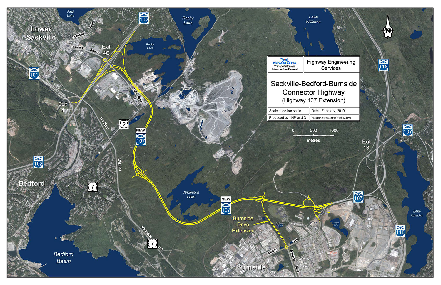
The highway is being extended from Akerley Boulevard along the southwestern side of Anderson Lake and from there continuing north to connect to Duke Street/Glendale Avenue near exit 4C on Highway 102. This extension, known locally as the Burnside Expressway, will allow commuters from Halifax and Burnside heading to Sackville to bypass the Bedford Bypass and Windmill Road and instead go through Burnside and connect directly into Sackville. Construction is in progress.[6]
The Bedford to Burnside highway will open August 2024
Exit list[edit]
The entire route is located in Halifax Regional Municipality.
| Location | km[1] | mi | Exit | Destinations | Notes | |
|---|---|---|---|---|---|---|
| Lower Sackville Bedford | 10 | Hwy 102 exit 4C; future western terminus[7] | ||||
| Burnside | 11 | Burnside Drive (extension) | Future interchange (eastbound exit and westbound entrance)[7] | |||
| 0.0 | 0.0 | 12 | Akerley Boulevard | Future interchange (westbound exit and eastbound entrance);[7] Hwy 107 currently transitions to Akerley Boulevard | ||
| Dartmouth | 2.2 | 1.4 | 13 | Signed as exit 13S (south) and 13N (north); Hwy 118 exit 13 | ||
| 5.8 | 3.6 | 14 | ||||
| 10.1 | 6.3 | At grade; western end of Trunk 7 concurrency | ||||
| Cherry Brook | 13.8 | 8.6 | At-grade | |||
| | 15.3 | 9.5 | 17 | At grade; eastern end of Trunk 7 concurrency | ||
| Mineville | 18.8 | 11.7 | 18 | |||
| Porters Lake | 27.0 | 16.8 | 19 | Eastbound exit, westbound entrance | ||
| 28.8 | 17.9 | 20 | ||||
| | 33.3 | 20.7 | 21 | Eastbound exit, westbound entrance | ||
| Musquodoboit Harbour | 40.2 | 25.0 | At-grade; Hwy 107 eastern terminus | |||
1.000 mi = 1.609 km; 1.000 km = 0.621 mi
| ||||||
References[edit]
- ^ a b c Google (July 14, 2017). "Highway 107 in Nova Scotia" (Map). Google Maps. Google. Retrieved July 14, 2017.
- ^ Annual Report of the Department of Highways for the fiscal year ended March 31, 1973. Halifax: Nova Scotia Department of Highways. 1973. p. 13.
Work was started on the first section of Highway 107, extending from Little Salmon Bridge outside Dartmouth to the Minesville Road in Preston, a distance of 3.0 miles.
- ^ Annual Report. Nova Scotia Department of Highways. 1976. p. 10.
Work started several years ago on this new highway on the Eastern Shore of Halifax County. The first three-mile section was paved and opened to traffic from a point outside Dartmouth to the Minesville Road in Preston. Grading work was continued as far as Lake Echo and two bridges were built across the lake.
- ^ a b Annual report for the fiscal year ending March 31, 1987. Nova Scotia Department of Transportation. 1987. p. 14.
- ^ Annual report for the fiscal year ending March 31, 1986. Nova Scotia Department of Transportation. 1986. p. 14.
One section, from Trunk 7 at Westphal to the Montague Road, was completed and opened to traffic. The remaining section, from the Montague Road to Highway 118 at Porto Bello, was near completion, with expected opening of the entire bypass to be in the summer of 1986.
- ^ Traffic Study for Highway 107 Phase 1 – Burnside to Sackville (PDF). Province of Nova Scotia (Report). Genivar. February 2011.
- ^ a b c Highway Engineering Services (February 2019). Sackville-Bedford-Burnside Connector Highway (Highway 107 Extension) (jpg) (Map). Nova Scotia Transportation and Infrastructure Renewal. Retrieved June 13, 2021.