
Pfronstetten
You can help expand this article with text translated from the corresponding article in German. (February 2009) Click [show] for important translation instructions.
|
Pfronstetten | |
|---|---|
 Coat of arms | |
Location of Pfronstetten within Reutlingen district 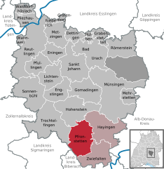 | |
 Pfronstetten  Pfronstetten | |
| Coordinates: 48°16′35″N 09°21′41″E / 48.27639°N 9.36139°E | |
| Country | Germany |
| State | Baden-Württemberg |
| Admin. region | Tübingen |
| District | Reutlingen |
| Subdivisions | 6 Ortsteile |
| Government | |
| • Mayor (2016–24) | Reinhold Teufel[1] |
| Area | |
| • Total | 54.10 km2 (20.89 sq mi) |
| Elevation | 748 m (2,454 ft) |
| Population (2022-12-31)[2] | |
| • Total | 1,512 |
| • Density | 28/km2 (72/sq mi) |
| Time zone | UTC+01:00 (CET) |
| • Summer (DST) | UTC+02:00 (CEST) |
| Postal codes | 72539 |
| Dialling codes | 07388 und 07373 |
| Vehicle registration | RT |
| Website | www.pfronstetten.de |
Pfronstetten is a town in the district of Reutlingen in Baden-Württemberg in Germany.
Geography[edit]
Geographical location[edit]
Pfronstetten is located in the Swabian Alb, about 25 km south of Reutlingen.
Neighboring municipalities[edit]
The following towns and municipalities border on the municipality of Pfronstetten, they are named clockwise starting in the north and belong to the district of Reutlingen or the districts of Biberach¹ and Sigmaringen.
Municipal division[edit]
A total of seven villages and farms belong to the municipality of Pfronstetten with the municipalities of Aichelau, Aichstetten, Geisingen, Huldstetten and Tigerfeld, which were independent until the municipal area reform in Baden-Württemberg. Only the villages of the same name belong to the municipal districts of Aichelau, Aichstetten, Geisingen, Huldstetten and Pfronstetten. The village of Tigerfeld and the St. Georgenhof farm belong to the district of Tigerfeld.
There are several abandoned villages in the municipality: The two villages of Höfle and Niklausenweiler in the Aichelau district. Niklausenweiler was built as a brickworks at the end of the 18th century, but did not exist for long; the village was named after Abbot Nikolaus von Zwiefalten. The deserted villages of Hendelheim or Hendenheim - the village was mentioned in 1352 as Hendenhain, the place name is still preserved as a field name -, Schäfbuch - the village was mentioned in the 11th and 12th centuries as Schefbuoch and Scepbouch - and Wolfriedeshalden, which was mentioned in the 11th century as Wolfridushaldun, are located in the district of Pfronstetten.[3]
References[edit]
- ^ Aktuelle Wahlergebnisse, Staatsanzeiger, accessed 14 September 2021.
- ^ "Bevölkerung nach Nationalität und Geschlecht am 31. Dezember 2022" [Population by nationality and sex as of December 31, 2022] (CSV) (in German). Statistisches Landesamt Baden-Württemberg. June 2023.
- ^ Das Land Baden-Württemberg. Amtliche Beschreibung nach Kreisen und Gemeinden. Band VII: Regierungsbezirk Tübingen. Kohlhammer, Stuttgart 1978, ISBN 3-17-004807-4. S. 96–98
Towns and municipalities in Reutlingen (district) | ||
|---|---|---|
Unincorporated: Gutsbezirk Münsingen |  | |
| International | |
|---|---|
| National | |
This Reutlingen district location article is a stub. You can help Wikipedia by expanding it. |