
Portal:Caribbean
| Main Portal page | Indices | Projects |
 |
 |

| |
The Caribbean (/ˌkærɪˈbiːən, kəˈrɪbiən/ KARR-ih-BEE-ən, kə-RIB-ee-ən, locally /ˈkærɪbiːæn/ KARR-ih-bee-an; Spanish: el Caribe; French: les Caraïbes; Dutch: de Caraïben) is a subregion of the Americas that includes the Caribbean Sea and its islands, some of which are surrounded by the Caribbean Sea and some of which border both the Caribbean Sea and the North Atlantic Ocean; the nearby coastal areas on the mainland are sometimes also included in the region. The region is south-east of the Gulf of Mexico and Northern America, east of Central America, and north of South America.
Situated largely on the Caribbean Plate, the region has more than 700 islands, islets, reefs, and cays. Island arcs delineate the northern and eastern edges of the Caribbean Sea: the Greater Antilles in the north and the Lesser Antilles, which includes the Leeward Antilles, in the east and south. The nearby Lucayan Archipelago, comprising The Bahamas and the Turks and Caicos Islands, is considered to be a part of the Caribbean despite not bordering the Caribbean Sea. All the islands in the Antilles plus the Lucayan Archipelago form the West Indies, which is often interchangeable with the term Caribbean. On the mainland, Belize, the eastern and northern coasts of Central and South American countries such as the Bay Islands Department of Honduras, the North and South Caribbean Autonomous Regions of Nicaragua, the Limón Province of Costa Rica, and the Archipelago of San Andrés, Providencia and Santa Catalina of Colombia are also considered culturally Caribbean. French Guiana, Guyana, Panama, and Suriname are often included as parts of the Caribbean due to their political and cultural ties with the region.
Geopolitically, the islands of the Caribbean are often regarded as a subregion of North America, though sometimes they are included in Middle America or left as a subregion of their own; alternately, the term "Caribbean" may have the intended exclusion, or even unintentional inclusion, as part of Latin America. Generally the Caribbean area is organized into 33 political entities, including 13 sovereign states, 12 dependencies, historical disputed territories have existed, and seven other overseas territories. From 15 December 1954 to 10 October 2010, there was a territory known as the Netherlands Antilles composed of five islands, all of which were Dutch dependencies. From 3 January 1958 to 31 May 1962, there was also a short-lived political union called the British West Indies Federation composed of ten English-speaking Caribbean territories, all of which were then British dependencies. (Full article...)
 Good article -

Edwin Lloyd St Hill (9 March 1904 – 21 May 1957) was a Trinidadian cricketer who played two Test matches for the West Indies in 1930. His brothers, Wilton and Cyl, also played for Trinidad and Tobago; in addition, the former played Test matches for the West Indies.
St Hill first played local cricket in with some success and graduated to the Trinidad and Tobago team. He played regularly for the next five years but was not selected for any representative West Indian teams. His increased success in 1929 attracted the attention of the West Indies selectors, and he played two Test matches against England in 1930. (Full article...)Selected geography article -

The Cayman Islands (/ˈkeɪmən/) is a self-governing British Overseas Territory, and the largest by population. The 264-square-kilometre (102-square-mile) territory comprises the three islands of Grand Cayman, Cayman Brac and Little Cayman, which are located south of Cuba and north-east of Honduras, between Jamaica and Mexico's Yucatán Peninsula. The capital city is George Town on Grand Cayman, which is the most populous of the three islands.
The Cayman Islands is considered to be part of the geographic Western Caribbean zone as well as the Greater Antilles. The territory is a major offshore financial centre for international businesses and wealthy individuals, largely as a result of the state not charging taxes on any income earned or stored. (Full article...)Selected fare or cuisine -

Did you know? -

- ...that Calico Jack (pictured), an English pirate captain during the early 18th century, was executed with most of his crew in Jamaica on 17 November 1720?
- ...that the oldest known son is "Son de la Má Teodora", a traditional Cuban musical piece which has been traced back to the 1570s?
- ...that Saint Vincent was a major filming location for the Pirates of the Caribbean movies?
Related portals
Wikiproject
 Featured article -

Hurricane Hazel was the deadliest, second-costliest, and most intense hurricane of the 1954 Atlantic hurricane season. The storm killed at least 469 people in Haiti before it struck the United States near the border between North and South Carolina as a Category 4 hurricane. After causing 95 fatalities in the US, Hazel struck Canada as an extratropical storm, which raised the death toll by 81 people, mostly in Toronto. As a result of the high death toll and the damage caused by Hazel, its name was retired from use for North Atlantic hurricanes.
In Haiti, Hazel destroyed 40 percent of the coffee trees and 50 percent of the cacao crop, which affected the economy for several years. The hurricane made landfall near Calabash, North Carolina, and destroyed most waterfront dwellings. It then traveled north along the Atlantic coast. Hazel affected Virginia; Washington, D.C.; West Virginia; Maryland; Delaware; New Jersey; Pennsylvania; and New York. It brought gusts near 160 km/h (100 mph) and caused $281 million (1954 USD) in damage. When it was over Pennsylvania, Hazel consolidated with a cold front and turned northwest towards Canada. When it hit Ontario as an extratropical storm, rivers and streams in and around Toronto overflowed their banks, which caused severe flooding. As a result, many residential areas in the local floodplains, such as the Raymore Drive area, were subsequently converted to parkland. In Canada alone, over C$135 million (2021: C$1.4 billion) of damage was incurred. (Full article...)Selected image -

Steelband in Port of Spain, Trinidad, in the early 1950s.
Selected music -
General images
-
 Sir Ralph Abercromby, Commander of the British forces that captured Trinidad and Tobago. (from History of the Caribbean)
 -
-
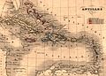 Map of Antilles / Caribbean in 1843. (from History of the Caribbean)
 -
 The forced African migrants brought to the Caribbean lived in inhumane conditions. Above are examples of slave huts in Dutch Bonaire. About 5 feet tall and 6 feet wide, between 2 and 3 slaves slept in these after working in nearby salt mines. (from History of the Caribbean)
 -
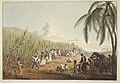
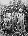 Cane cutters in Jamaica, 1880s. (from History of the Caribbean)
 -
 The Piazza (or main square) in central Havana, Cuba, in 1762, during the Seven Years' War. (from History of the Caribbean)
 -
 Illustration circa 1815 showing "Incendie du Cap" (Burning of Cape Francais) during the Haitian Revolution. The caption reads: "General revolt of the Blacks. Massacre of the Whites". (from History of the Caribbean)
 -
 The Natives of Cumaná attack the mission after Gonzalo de Ocampo's slaving raid. Colored copperplate by Theodor de Bry, published in the "Relación brevissima de la destruccion de las Indias". (from History of the Caribbean)
 -

-
 Battle of the Saintes by Thomas Mitchell. This 1782 battle between the British and French navies took place near Guadeloupe. (from History of the Caribbean)
 -
 A carriage on a street in Martinique, one of the Caribbean islands that has not become independent. It is an overseas region of France, and its citizens are full French citizens. (from History of the Caribbean)
 -
 United States' rescue effort at St. Vincent, 1902, following an eruption of the volcano at La Soufrière. (from History of the Caribbean)
 -
 A linen market in the British West Indies, circa 1780 (from History of the Caribbean)
 -
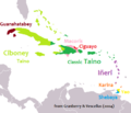 Linguistic map of the Caribbean in CE 1500, before European colonization (from History of the Caribbean)
 -
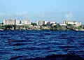
 A container ship docked in the deep water harbour of Bridgetown, Barbados, which opened in 1961. (from History of the Caribbean)
 -
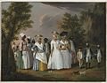 Agostino Brunias. Free Women of Color with Their Children and Servants in a Landscape, ca. 1770-1796 Brooklyn Museum (from Culture of the Caribbean)
 -
 A 19th-century lithograph by Theodore Bray showing a sugarcane plantation. On right is "white officer", the European overseer, surveilling plantation workers. To the left is a flat-bottomed vessel for cane transportation. (from History of the Caribbean)
 -
 A 1906 advertisement in the Montreal Medical Journal, showing the United Fruit Company selling trips to Jamaica. (from History of the Caribbean)
 -
-
 Bath Hotel, Nevis, photograph by Jose Anjo of Antigua (from Tourism in Latin America and the Caribbean)
 -
 A medallion showing the Capture of Trinidad and Tobago by the British in 1797. (from History of the Caribbean)
 -
 Crane Resort old and new buildings, Cobblers Reef, Barbados (from Tourism in Latin America and the Caribbean)
 -
 Political evolution of Central America and the Caribbean from 1700 to present (from History of the Caribbean)
 -
 Contemporary political map of the Caribbean (from History of the Caribbean)
 -
 Spanish Caribbean Islands in the American Viceroyalties 1600. (from History of the Caribbean)
 -
 American 757 on final approach to Saint Maarten Airport (from Tourism in Latin America and the Caribbean)

,_plate_IV_-_BL.jpg)


.jpg)


Caribbean topics
Categories

New articles
Rules | Match log | Results page (for watching) | Last updated: 2024-05-10 19:48 (UTC)
Note: The list display can now be customized by each user. See List display personalization for details.
- Caritas Colombia (edit | talk | history | links | watch | logs | tools) by Bdx (talk · contribs · new pages (35)) started on 2024-05-10, score: 16
- 1996 United States Virgin Islands general election (edit | talk | history | links | watch | logs | tools) by Yilku1 (talk · contribs · new pages (22)) started on 2024-05-10, score: 16
- 1994 United States Virgin Islands general election (edit | talk | history | links | watch | logs | tools) by Yilku1 (talk · contribs · new pages (22)) started on 2024-05-10, score: 16
- La Durango (edit | talk | history | links | watch | logs | tools) by Floppykart (talk · contribs · new pages (32)) started on 2024-05-10, score: 16
- Juan Delgado (baroque painter) (edit | talk | history | links | watch | logs | tools) by Sonero9 (talk · contribs · new pages (2)) started on 2024-05-10, score: 16
- 1992 United States Virgin Islands general election (edit | talk | history | links | watch | logs | tools) by Yilku1 (talk · contribs · new pages (22)) started on 2024-05-10, score: 16
- 1990 United States Virgin Islands general election (edit | talk | history | links | watch | logs | tools) by Yilku1 (talk · contribs · new pages (22)) started on 2024-05-10, score: 16
- Weather of 2001 (edit | talk | history | links | watch | logs | tools) by MemeGod27 (talk · contribs · new pages (12)) started on 2024-05-10, score: 16
- Nicholson Ducreay (edit | talk | history | links | watch | logs | tools) by Sammielh (talk · contribs · new pages (6)) started on 2024-05-10, score: 24
- List of United States governors born outside the United States (edit | talk | history | links | watch | logs | tools) by Hemant Dabral (talk · contribs · new pages (21)) started on 2024-05-10, score: 24
- Noche de Pasión (song) (edit | talk | history | links | watch | logs | tools) by DominicanWikiEdit1996 (talk · contribs · new pages (5)) started on 2024-05-10, score: 16
- Krishnamachari Srikkanth (edit | talk | history | links | watch | logs | tools) by 106.222.196.102 (talk · contribs · new pages (1)) started on 2024-05-10, score: 16
- 1986 United States Virgin Islands general election (edit | talk | history | links | watch | logs | tools) by Yilku1 (talk · contribs · new pages (22)) started on 2024-05-10, score: 16
- Los Kakukomicos (edit | talk | history | links | watch | logs | tools) by JeanetteMartin (talk · contribs · new pages (8)) started on 2024-05-10, score: 16
- 1982 United States Virgin Islands general election (edit | talk | history | links | watch | logs | tools) by Yilku1 (talk · contribs · new pages (22)) started on 2024-05-10, score: 16
- 1977 United States Virgin Islands Constitutional Convention election (edit | talk | history | links | watch | logs | tools) by Yilku1 (talk · contribs · new pages (22)) started on 2024-05-09, score: 16
- La Dame Blanche (edit | talk | history | links | watch | logs | tools) by Qcne (talk · contribs · new pages (22)) started on 2024-05-09, score: 24
- Quiina guianensis (edit | talk | history | links | watch | logs | tools) by CycoMa1 (talk · contribs · new pages (6)) started on 2024-05-08, score: 16
- George Allan Madden (edit | talk | history | links | watch | logs | tools) by WikiOriginal-9 (talk · contribs · new pages (139)) started on 2024-05-09, score: 12
- Christian Lilly (edit | talk | history | links | watch | logs | tools) by WikiOriginal-9 (talk · contribs · new pages (139)) started on 2024-05-09, score: 56
- De Carolina (edit | talk | history | links | watch | logs | tools) by آرمین هویدایی (talk · contribs · new pages (4)) started on 2024-05-09, score: 16
- Samuel Raymond Jarvis (edit | talk | history | links | watch | logs | tools) by Waggers (talk · contribs · new pages (2)) started on 2024-05-09, score: 32
- 2024–25 CONCACAF Nations League C (edit | talk | history | links | watch | logs | tools) by Thiago89 (talk · contribs · new pages (9)) started on 2024-05-09, score: 56
- Conquering Lion (album) (edit | talk | history | links | watch | logs | tools) by GanzKnusper (talk · contribs · new pages (10)) started on 2024-05-09, score: 16
- Kate Wilmott (edit | talk | history | links | watch | logs | tools) by Goodknowme (talk · contribs · new pages (5)) started on 2024-05-09, score: 32
- Tripsacum lanceolatum (edit | talk | history | links | watch | logs | tools) by WelwitschiaTokarev (talk · contribs · new pages (3)) started on 2024-05-09, score: 16
- Inauguration of Andrés Pastrana (edit | talk | history | links | watch | logs | tools) by AlexExpensive (talk · contribs · new pages (20)) started on 2024-05-09, score: 16
- Charles P. Buchanan (edit | talk | history | links | watch | logs | tools) by Dougiethelass (talk · contribs · new pages (1)) started on 2024-05-08, score: 16
- List of ambassadors of Spain to the Dominican Republic (edit | talk | history | links | watch | logs | tools) by DACC23 (talk · contribs · new pages (29)) started on 2024-05-08, score: 24
- Rusking Pimentel (edit | talk | history | links | watch | logs | tools) by Caddygypsy (talk · contribs · new pages (1)) started on 2024-05-08, score: 32
- Adam Bednarik (edit | talk | history | links | watch | logs | tools) by Yearingout (talk · contribs · new pages (1)) started on 2024-05-05, score: 16
- Adivino (song) (edit | talk | history | links | watch | logs | tools) by Floppykart (talk · contribs · new pages (32)) started on 2024-05-08, score: 16
- St. Albert the Great Priory (edit | talk | history | links | watch | logs | tools) by Qcne (talk · contribs · new pages (22)) started on 2024-05-08, score: 16
- Robert Grant (Royal Engineers) (edit | talk | history | links | watch | logs | tools) by WikiOriginal-9 (talk · contribs · new pages (139)) started on 2024-05-08, score: 16
- Bby Boo (edit | talk | history | links | watch | logs | tools) by 222 Goshiy (talk · contribs · new pages (1)) started on 2024-05-08, score: 16
- Lists of Italian Americans (edit | talk | history | links | watch | logs | tools) by Omnis Scientia (talk · contribs · new pages (9)) started on 2024-05-08, score: 24
- Arthur William Mahaffy (edit | talk | history | links | watch | logs | tools) by Xegma (talk · contribs · new pages (5)) started on 2024-05-08, score: 16
- NSGB (edit | talk | history | links | watch | logs | tools) by AllTheUsernamesAreInUse (talk · contribs · new pages (188)) started on 2024-05-07, score: 16
- Elsie Etheart (edit | talk | history | links | watch | logs | tools) by Bookworm-ce (talk · contribs · new pages (28)) started on 2024-05-07, score: 16
- Pineapple mania (edit | talk | history | links | watch | logs | tools) by Viriditas (talk · contribs · new pages (5)) started on 2024-05-07, score: 24
- Tyler Ferguson (edit | talk | history | links | watch | logs | tools) by Stonecold415 (talk · contribs · new pages (4)) started on 2024-05-07, score: 12
- Pedro José de Zulueta, 2nd Count of Torre Díaz (edit | talk | history | links | watch | logs | tools) by DACC23 (talk · contribs · new pages (29)) started on 2024-05-07, score: 16
- Latin American Federation of Journalists (edit | talk | history | links | watch | logs | tools) by Bookworm-ce (talk · contribs · new pages (28)) started on 2024-05-07, score: 24
- Casting the Atlantic (edit | talk | history | links | watch | logs | tools) by Cantillismo (talk · contribs · new pages (1)) started on 2024-05-07, score: 16
- List of elections in 2026 (edit | talk | history | links | watch | logs | tools) by Yoblyblob (talk · contribs · new pages (27)) started on 2024-05-07, score: 16
- Museo de las Américas (edit | talk | history | links | watch | logs | tools) by Blapgar (talk · contribs · new pages (1)) started on 2024-05-07, score: 16
- 2025 Belizean general election (edit | talk | history | links | watch | logs | tools) by Yoblyblob (talk · contribs · new pages (27)) started on 2024-05-07, score: 19
- Cuban Boxing Federation (edit | talk | history | links | watch | logs | tools) by EssNS (talk · contribs · new pages (11)) started on 2024-05-07, score: 16
- Suriname national futsal team (edit | talk | history | links | watch | logs | tools) by HitroMilanese (talk · contribs · new pages (15)) started on 2024-05-07, score: 56
- Giraldo Cordova Cardin International Boxing Tournament (edit | talk | history | links | watch | logs | tools) by EssNS (talk · contribs · new pages (11)) started on 2024-05-07, score: 16
- Plaza del Atlántico (edit | talk | history | links | watch | logs | tools) by Ruud Buitelaar (talk · contribs · new pages (5)) started on 2024-05-07, score: 24
- Brunache (edit | talk | history | links | watch | logs | tools) by Zigzig20s (talk · contribs · new pages (25)) started on 2024-05-07, score: 16
- List of IMAX venues with 15/70 or laser projectors (edit | talk | history | links | watch | logs | tools) by Travelling nomad1 (talk · contribs · new pages (2)) started on 2024-05-06, score: 24
- List of Phi Delta Epsilon chapters (edit | talk | history | links | watch | logs | tools) by Jax MN (talk · contribs · new pages (4)) started on 2024-05-06, score: 16
- The Firing Squad (2024 film) (edit | talk | history | links | watch | logs | tools) by The Film Creator (talk · contribs · new pages (18)) started on 2024-05-06, score: 16
- Carmen Vazquez Rivera (edit | talk | history | links | watch | logs | tools) by Atlasunivers (talk · contribs · new pages (1)) started on 2024-05-06, score: 24
- C, XOXO (edit | talk | history | links | watch | logs | tools) by Nikolasivy13 (talk · contribs · new pages (2)) started on 2024-05-06, score: 16
- Deaths in April 2024 (edit | talk | history | links | watch | logs | tools) by Rusted AutoParts (talk · contribs · new pages (7)) started on 2024-05-06, score: 24
- Baticano (edit | talk | history | links | watch | logs | tools) by Floppykart (talk · contribs · new pages (32)) started on 2024-05-06, score: 16
- Lyndon Campos (edit | talk | history | links | watch | logs | tools) by Pietaster (talk · contribs · new pages (22)) started on 2024-05-06, score: 16
- Palais de la Belle Rivière (edit | talk | history | links | watch | logs | tools) by Ipflo (talk · contribs · new pages (11)) started on 2024-05-06, score: 16
- 2024 World Athletics Relays – Women's 4 × 100 metres relay (edit | talk | history | links | watch | logs | tools) by Habst (talk · contribs · new pages (104)) started on 2024-05-06, score: 16
- 2024 World Athletics Relays – Women's 4 × 400 metres relay (edit | talk | history | links | watch | logs | tools) by Jennypedia (talk · contribs · new pages (2)) started on 2024-05-06, score: 16
- 2024 World Athletics Relays – Men's 4 × 400 metres relay (edit | talk | history | links | watch | logs | tools) by Habst (talk · contribs · new pages (104)) started on 2024-05-06, score: 16
- BeyGood (edit | talk | history | links | watch | logs | tools) by Newpicarchive (talk · contribs · new pages (1)) started on 2024-05-06, score: 16
- 1995 Choco earthquake (edit | talk | history | links | watch | logs | tools) by LeSwiss1886 (talk · contribs · new pages (1)) started on 2024-05-06, score: 16
- Randy Rodríguez (edit | talk | history | links | watch | logs | tools) by Stonecold415 (talk · contribs · new pages (4)) started on 2024-05-06, score: 16
- Results of the 2012 Ukrainian parliamentary election in the foreign electoral district (edit | talk | history | links | watch | logs | tools) by Lastjourneyman. (talk · contribs · new pages (2)) started on 2024-05-05, score: 24
- Latin Caribbean (edit | talk | history | links | watch | logs | tools) by GreekApple123 (talk · contribs · new pages (44)) started on 2024-05-05, score: 107
- Dorsainvil (edit | talk | history | links | watch | logs | tools) by Edwardx (talk · contribs · new pages (87)) started on 2024-05-05, score: 16
- Charles Oscar Etienne (Chaloska) (edit | talk | history | links | watch | logs | tools) by Alyssa.Bustos (talk · contribs · new pages (1)) started on 2024-05-05, score: 44
- 2024 World Athletics Relays – Mixed 4 × 400 metres relay (edit | talk | history | links | watch | logs | tools) by Jennypedia (talk · contribs · new pages (2)) started on 2024-05-05, score: 16
- Vancouver Knights (edit | talk | history | links | watch | logs | tools) by Sagar Singh 9 (talk · contribs · new pages (7)) started on 2024-05-03, score: 16
- Harry M. Locke (edit | talk | history | links | watch | logs | tools) by Jeffrey Beall (talk · contribs · new pages (1)) started on 2024-05-05, score: 16
- Dagoberto (edit | talk | history | links | watch | logs | tools) by GiantSnowman (talk · contribs · new pages (34)) started on 2024-05-05, score: 16
- Adi Oasis (edit | talk | history | links | watch | logs | tools) by EmphaXVI (talk · contribs · new pages (1)) started on 2024-05-05, score: 24
- Bryan Ramos (baseball) (edit | talk | history | links | watch | logs | tools) by Pozzi.c (talk · contribs · new pages (1)) started on 2024-05-05, score: 16
- 2024 World Athletics Relays – Men's 4 × 100 metres relay (edit | talk | history | links | watch | logs | tools) by Alibene567 (talk · contribs · new pages (2)) started on 2024-05-05, score: 32
- Luis Enrique Patterson (edit | talk | history | links | watch | logs | tools) by Betterthanbutter (talk · contribs · new pages (1)) started on 2024-05-05, score: 32
- Cardamine occulta (edit | talk | history | links | watch | logs | tools) by Abductive (talk · contribs · new pages (37)) started on 2024-05-05, score: 16
- Civil Service College (edit | talk | history | links | watch | logs | tools) by ΚΚ ΙΝ ΗΚ (talk · contribs · new pages (5)) started on 2024-05-05, score: 16
- Alberto Bosch y Fustegueras (edit | talk | history | links | watch | logs | tools) by Barr Theo (talk · contribs · new pages (52)) started on 2024-05-04, score: 16
- Edelweiss Capital Group Limited (edit | talk | history | links | watch | logs | tools) by Limbo.J (talk · contribs · new pages (1)) started on 2024-05-04, score: 16
- Carolina Armenteros (edit | talk | history | links | watch | logs | tools) by Trakking (talk · contribs · new pages (2)) started on 2024-05-04, score: 16
- Lejos del Cielo (edit | talk | history | links | watch | logs | tools) by آرمین هویدایی (talk · contribs · new pages (4)) started on 2024-05-04, score: 24
- Costa Rica–Panama relations (edit | talk | history | links | watch | logs | tools) by Rkt2312 (talk · contribs · new pages (12)) started on 2024-05-04, score: 16
- Anna Stembridge (edit | talk | history | links | watch | logs | tools) by Djln19 (talk · contribs · new pages (8)) started on 2024-05-04, score: 16
- Costa Rica–Nicaragua relations (edit | talk | history | links | watch | logs | tools) by Rkt2312 (talk · contribs · new pages (12)) started on 2024-05-04, score: 16
- Honduras–Nicaragua relations (edit | talk | history | links | watch | logs | tools) by Rkt2312 (talk · contribs · new pages (12)) started on 2024-05-04, score: 16
- Claire Jimenez (edit | talk | history | links | watch | logs | tools) by Ruth Bader Yinzburg (talk · contribs · new pages (4)) started on 2024-05-04, score: 16
- Independence Day (Haiti) (edit | talk | history | links | watch | logs | tools) by TheBrowniess (talk · contribs · new pages (9)) started on 2024-05-03, score: 16
- W. J. Kruys (edit | talk | history | links | watch | logs | tools) by CroiXXX (talk · contribs · new pages (8)) started on 2024-04-26, score: 16
- El Salvador–Honduras relations (edit | talk | history | links | watch | logs | tools) by Rkt2312 (talk · contribs · new pages (12)) started on 2024-05-04, score: 16
- El Salvador–Guatemala relations (edit | talk | history | links | watch | logs | tools) by Rkt2312 (talk · contribs · new pages (12)) started on 2024-05-04, score: 16
- Roger Shakespear (edit | talk | history | links | watch | logs | tools) by HangingSwordAlley (talk · contribs · new pages (2)) started on 2024-05-04, score: 32
- Guatemala–Honduras relations (edit | talk | history | links | watch | logs | tools) by Rkt2312 (talk · contribs · new pages (12)) started on 2024-05-04, score: 16
- Eric Zolov (edit | talk | history | links | watch | logs | tools) by Reykcultura7193 (talk · contribs · new pages (4)) started on 2024-05-04, score: 24
- Embassy of Haiti, Taipei (edit | talk | history | links | watch | logs | tools) by Zinderboff (talk · contribs · new pages (16)) started on 2024-05-04, score: 16
- List of Danish colonial trading posts and settlements (edit | talk | history | links | watch | logs | tools) by Tinkaer1991 (talk · contribs · new pages (7)) started on 2024-05-04, score: 24
- Deaths in February 1987 (edit | talk | history | links | watch | logs | tools) by Mill 1 (talk · contribs · new pages (13)) started on 2024-05-04, score: 24
- Wilfredo Ferrer (edit | talk | history | links | watch | logs | tools) by Pietaster (talk · contribs · new pages (22)) started on 2024-05-04, score: 27
- Deaths in March 1987 (edit | talk | history | links | watch | logs | tools) by Mill 1 (talk · contribs · new pages (13)) started on 2024-05-04, score: 24
- Carlos Rivera (politician) (edit | talk | history | links | watch | logs | tools) by Unknown Temptation (talk · contribs · new pages (13)) started on 2024-05-04, score: 16
- Miss Grand United States Virgin Islands 2024 (edit | talk | history | links | watch | logs | tools) by Thomson Walt (talk · contribs · new pages (13)) started on 2024-05-04, score: 24
- Beryl Piccolantonio (edit | talk | history | links | watch | logs | tools) by Ktkvtsh (talk · contribs · new pages (13)) started on 2024-05-04, score: 16
- Alfonso Ardura (edit | talk | history | links | watch | logs | tools) by Barr Theo (talk · contribs · new pages (52)) started on 2024-05-03, score: 16
- 1940 United States Virgin Islands general election (edit | talk | history | links | watch | logs | tools) by Longestview (talk · contribs · new pages (6)) started on 2024-05-03, score: 16
- Deaths in April 1987 (edit | talk | history | links | watch | logs | tools) by Mill 1 (talk · contribs · new pages (13)) started on 2024-05-03, score: 24
- Deaths in June 1987 (edit | talk | history | links | watch | logs | tools) by Mill 1 (talk · contribs · new pages (13)) started on 2024-05-03, score: 48
- Henry Klein (edit | talk | history | links | watch | logs | tools) by GiantSnowman (talk · contribs · new pages (34)) started on 2024-05-03, score: 16
- Helen Jane Gladstone (edit | talk | history | links | watch | logs | tools) by GnocchiFan (talk · contribs · new pages (12)) started on 2024-04-29, score: 16
- Pancho Mansfield (edit | talk | history | links | watch | logs | tools) by Jmondry (talk · contribs · new pages (0)) started on 2024-04-23, score: 32
- Bayron (edit | talk | history | links | watch | logs | tools) by Duckmather (talk · contribs · new pages (103)) started on 2024-05-03, score: 16
- Rojé Stona (edit | talk | history | links | watch | logs | tools) by Hildreth gazzard (talk · contribs · new pages (84)) started on 2024-05-03, score: 16
- 2004 North Carolina Democratic presidential caucuses (edit | talk | history | links | watch | logs | tools) by SphealKent (talk · contribs · new pages (1)) started on 2024-05-03, score: 16
- Census in Jamaica (edit | talk | history | links | watch | logs | tools) by Jeffrolland (talk · contribs · new pages (1)) started on 2024-05-03, score: 16
- Mister Venezuela 1998 (edit | talk | history | links | watch | logs | tools) by Mauriziok (talk · contribs · new pages (49)) started on 2024-05-03, score: 20
- Pedro Pagés (edit | talk | history | links | watch | logs | tools) by Robertsky (talk · contribs · new pages (50)) started on 2024-05-03, score: 16
- Princesa (song) (edit | talk | history | links | watch | logs | tools) by DominicanWikiEdit1996 (talk · contribs · new pages (5)) started on 2024-05-02, score: 16
- John Edwards Caldwell (edit | talk | history | links | watch | logs | tools) by DMVHistorian (talk · contribs · new pages (11)) started on 2024-05-02, score: 16
- List of ambassadors and high commissioners to New Zealand (edit | talk | history | links | watch | logs | tools) by Bouzinac (talk · contribs · new pages (2)) started on 2024-05-02, score: 16
- SS Nyassa (edit | talk | history | links | watch | logs | tools) by Motacilla (talk · contribs · new pages (3)) started on 2024-05-02, score: 32
- Fiorinia phantasma (edit | talk | history | links | watch | logs | tools) by Bernhard Zelazny (talk · contribs · new pages (11)) started on 2024-05-02, score: 16
- Admetula formosa (edit | talk | history | links | watch | logs | tools) by JoJan (talk · contribs · new pages (29)) started on 2024-05-02, score: 16
- Tharan Yaub Yuhanim (edit | talk | history | links | watch | logs | tools) by Yusuf Asar Yathar (talk · contribs · new pages (11)) started on 2024-05-02, score: 16
- Eugenio Martínez Thedy (edit | talk | history | links | watch | logs | tools) by Fadesga (talk · contribs · new pages (4)) started on 2024-05-02, score: 16
- Samuel Joyce Thomas (edit | talk | history | links | watch | logs | tools) by C411978 (talk · contribs · new pages (8)) started on 2024-05-02, score: 16
- Dasvibes (edit | talk | history | links | watch | logs | tools) by Ubs45ya (talk · contribs · new pages (1)) started on 2024-05-02, score: 16
- Peter Bown (edit | talk | history | links | watch | logs | tools) by Solde (talk · contribs · new pages (1)) started on 2024-05-02, score: 16
- Antonio Alonso (edit | talk | history | links | watch | logs | tools) by Barr Theo (talk · contribs · new pages (52)) started on 2024-05-01, score: 16
- 2024 CONCACAF Champions Cup final (edit | talk | history | links | watch | logs | tools) by 2pou (talk · contribs · new pages (29)) started on 2024-05-01, score: 16
- Zootopia 2 (edit | talk | history | links | watch | logs | tools) by 2604:3D09:7A7C:B200:F1BE:83FF:8531:8019 (talk · contribs · new pages (1)) started on 2024-05-01, score: 16
- A. A. Priestley's cricket team in the West Indies in 1896–97 (edit | talk | history | links | watch | logs | tools) by Batagur baska (talk · contribs · new pages (55)) started on 2024-05-01, score: 56
- List of Phi Kappa Phi chapters (edit | talk | history | links | watch | logs | tools) by Rublamb (talk · contribs · new pages (4)) started on 2024-04-30, score: 16
- Rochelle Neil (edit | talk | history | links | watch | logs | tools) by Hildreth gazzard (talk · contribs · new pages (84)) started on 2024-04-28, score: 16
- Solo Te Amo (edit | talk | history | links | watch | logs | tools) by DominicanWikiEdit1996 (talk · contribs · new pages (5)) started on 2024-05-01, score: 16
- Triste Verano (edit | talk | history | links | watch | logs | tools) by Floppykart (talk · contribs · new pages (32)) started on 2024-05-01, score: 16
- Fritz Bélizaire (edit | talk | history | links | watch | logs | tools) by SashiRolls (talk · contribs · new pages (6)) started on 2024-05-01, score: 16
- Jany Martínez-Ward (edit | talk | history | links | watch | logs | tools) by Seenery (talk · contribs · new pages (3)) started on 2024-05-01, score: 16
- South Africa at the 2024 ICC Men's T20 World Cup (edit | talk | history | links | watch | logs | tools) by Wowlastic10 (talk · contribs · new pages (10)) started on 2024-05-01, score: 16
- Afghanistan at the 2024 ICC Men's T20 World Cup (edit | talk | history | links | watch | logs | tools) by Wowlastic10 (talk · contribs · new pages (10)) started on 2024-05-01, score: 24
- England at the 2024 ICC Men's T20 World Cup (edit | talk | history | links | watch | logs | tools) by Wowlastic10 (talk · contribs · new pages (10)) started on 2024-05-01, score: 24
- Ecuador women's national under-17 football team (edit | talk | history | links | watch | logs | tools) by SunsetRunner77 (talk · contribs · new pages (3)) started on 2024-05-01, score: 16
- Luis Armelio Garcia (edit | talk | history | links | watch | logs | tools) by Das osmnezz (talk · contribs · new pages (65)) started on 2024-05-01, score: 56
- Caritas Mexico (edit | talk | history | links | watch | logs | tools) by Bdx (talk · contribs · new pages (35)) started on 2024-05-01, score: 16
- Scarlin Hernandez (edit | talk | history | links | watch | logs | tools) by Theroadislong (talk · contribs · new pages (8)) started on 2024-05-01, score: 16
- List of Ethical Culture Fieldston School alumni (edit | talk | history | links | watch | logs | tools) by Melchior2006 (talk · contribs · new pages (5)) started on 2024-05-01, score: 16
- Australia at the 2024 ICC Men's T20 World Cup (edit | talk | history | links | watch | logs | tools) by Wowlastic10 (talk · contribs · new pages (10)) started on 2024-05-01, score: 32
- Maxuell Samurai (edit | talk | history | links | watch | logs | tools) by Jelajahlangit (talk · contribs · new pages (5)) started on 2024-05-01, score: 16
- Disruption of the water cycle in Haiti (edit | talk | history | links | watch | logs | tools) by Delpolocovy (talk · contribs · new pages (2)) started on 2024-05-01, score: 24
- Anestesiada (edit | talk | history | links | watch | logs | tools) by DominicanWikiEdit1996 (talk · contribs · new pages (5)) started on 2024-05-01, score: 16
- Timeline of the 1993 Atlantic hurricane season (edit | talk | history | links | watch | logs | tools) by Dylan620 (talk · contribs · new pages (2)) started on 2024-04-30, score: 96
- MV Commodore Clipper (edit | talk | history | links | watch | logs | tools) by 51.7.191.117 (talk · contribs · new pages (2)) started on 2024-04-29, score: 16
- Nhlakanipho MT Gumede (edit | talk | history | links | watch | logs | tools) by GumedeNhl (talk · contribs · new pages (2)) started on 2024-04-30, score: 16
- Nhlakanipho Mbongeni Theobald Gumede (edit | talk | history | links | watch | logs | tools) by GumedeNhl (talk · contribs · new pages (2)) started on 2024-04-30, score: 16
- Bicycles on stamps (edit | talk | history | links | watch | logs | tools) by GreatStellatedDodecahedron (talk · contribs · new pages (2)) started on 2024-04-30, score: 16
- Epsilon Telecommunications Limited (edit | talk | history | links | watch | logs | tools) by Bager Drukit (talk · contribs · new pages (1)) started on 2024-04-30, score: 16
- Doryan Rodríguez (edit | talk | history | links | watch | logs | tools) by Hildreth gazzard (talk · contribs · new pages (84)) started on 2024-04-30, score: 16
- Orelvis Martínez (edit | talk | history | links | watch | logs | tools) by Kline (talk · contribs · new pages (2)) started on 2024-04-30, score: 16
- Fermin de Sojo y Lomba (edit | talk | history | links | watch | logs | tools) by Barr Theo (talk · contribs · new pages (52)) started on 2024-04-29, score: 16
- 2024 Montserratian general election (edit | talk | history | links | watch | logs | tools) by Number 57 (talk · contribs · new pages (9)) started on 2024-04-29, score: 35
- Leo Wringer (edit | talk | history | links | watch | logs | tools) by Jessamyn (talk · contribs · new pages (1)) started on 2024-04-28, score: 16
- Khymani James (edit | talk | history | links | watch | logs | tools) by Slugger O'Toole (talk · contribs · new pages (4)) started on 2024-04-27, score: 16
- Widens Pkolo Dorsainville (edit | talk | history | links | watch | logs | tools) by Pkolo69d (talk · contribs · new pages (3)) started on 2024-04-18, score: 16
- Bacigalupi (surname) (edit | talk | history | links | watch | logs | tools) by Angusta (talk · contribs · new pages (2)) started on 2024-04-29, score: 16
- Melocactus macracanthos (edit | talk | history | links | watch | logs | tools) by Cs california (talk · contribs · new pages (14)) started on 2024-04-29, score: 16
- Melocactus harlowii (edit | talk | history | links | watch | logs | tools) by Cs california (talk · contribs · new pages (14)) started on 2024-04-29, score: 16
- 2024 ICC Men's T20 World Cup squads (edit | talk | history | links | watch | logs | tools) by Cric editor (talk · contribs · new pages (38)) started on 2024-04-29, score: 16
- United Nations Security Council Resolution 2692 (edit | talk | history | links | watch | logs | tools) by Maciej Mucharski (talk · contribs · new pages (6)) started on 2024-04-29, score: 16
- Elizabeth Yeampierre (edit | talk | history | links | watch | logs | tools) by CaptainAngus (talk · contribs · new pages (3)) started on 2024-04-29, score: 16
- Cuzcodinella (edit | talk | history | links | watch | logs | tools) by Premeditated Chaos (talk · contribs · new pages (43)) started on 2024-04-28, score: 16
- Emmanuel Ramírez (edit | talk | history | links | watch | logs | tools) by Stonecold415 (talk · contribs · new pages (4)) started on 2024-04-28, score: 16
- Panties y Brasieres (edit | talk | history | links | watch | logs | tools) by آرمین هویدایی (talk · contribs · new pages (4)) started on 2024-04-28, score: 16
- Emmanuel Ramirez (edit | talk | history | links | watch | logs | tools) by Stonecold415 (talk · contribs · new pages (4)) started on 2024-04-28, score: 16
- Ramonadoxa (edit | talk | history | links | watch | logs | tools) by Tom Radulovich (talk · contribs · new pages (138)) started on 2024-04-28, score: 16
- Derrick Etienne (edit | talk | history | links | watch | logs | tools) by RedPatch (talk · contribs · new pages (20)) started on 2024-04-28, score: 16
- Rainbow Alliance (disambiguation) (edit | talk | history | links | watch | logs | tools) by RoundSquare (talk · contribs · new pages (14)) started on 2024-04-28, score: 16
- Land mines in Latin America and the Caribbean (edit | talk | history | links | watch | logs | tools) by CaribDigita (talk · contribs · new pages (3)) started on 2024-04-27, score: 43
- Secundino (edit | talk | history | links | watch | logs | tools) by AllTheUsernamesAreInUse (talk · contribs · new pages (188)) started on 2024-04-27, score: 16
- Charles Bourne (edit | talk | history | links | watch | logs | tools) by Tassedethe (talk · contribs · new pages (428)) started on 2024-04-27, score: 16
- Haitian spaghetti (edit | talk | history | links | watch | logs | tools) by Valereee (talk · contribs · new pages (4)) started on 2024-04-27, score: 16
- Anasaitis milesae (edit | talk | history | links | watch | logs | tools) by Sarefo (talk · contribs · new pages (1)) started on 2024-04-26, score: 16
- 2025 national electoral calendar (edit | talk | history | links | watch | logs | tools) by ToadetteEdit (talk · contribs · new pages (87)) started on 2024-04-27, score: 16
- Deaths in August 1987 (edit | talk | history | links | watch | logs | tools) by Mill 1 (talk · contribs · new pages (13)) started on 2024-04-27, score: 48
- Deaths in September 1987 (edit | talk | history | links | watch | logs | tools) by Mill 1 (talk · contribs · new pages (13)) started on 2024-04-27, score: 16
- Buena Vista Social Club (musical) (edit | talk | history | links | watch | logs | tools) by HesioneHushabye (talk · contribs · new pages (16)) started on 2024-04-27, score: 16
- Grito de Lares flag (edit | talk | history | links | watch | logs | tools) by Tektonson (talk · contribs · new pages (1)) started on 2024-04-27, score: 72
- Banu Salman (edit | talk | history | links | watch | logs | tools) by Addimol (talk · contribs · new pages (4)) started on 2024-04-27, score: 16
- Vivian Ramón Pita (edit | talk | history | links | watch | logs | tools) by Jperez77 (talk · contribs · new pages (1)) started on 2024-04-26, score: 16
- Deaths in December 1987 (edit | talk | history | links | watch | logs | tools) by Mill 1 (talk · contribs · new pages (13)) started on 2024-04-26, score: 24
- WJ Kruys (edit | talk | history | links | watch | logs | tools) by CroiXXX (talk · contribs · new pages (8)) started on 2024-04-26, score: 16
- Ferxxocalipsis World Tour (edit | talk | history | links | watch | logs | tools) by Vlest (talk · contribs · new pages (3)) started on 2024-04-25, score: 16
- Otto Oppenheimer (television personality) (edit | talk | history | links | watch | logs | tools) by JeanetteMartin (talk · contribs · new pages (8)) started on 2024-04-26, score: 16
- Jacqueline Crooks (edit | talk | history | links | watch | logs | tools) by Il lupa (talk · contribs · new pages (3)) started on 2024-04-26, score: 16
- Kharavela's conquests and invasions (edit | talk | history | links | watch | logs | tools) by CandyCola4444 (talk · contribs · new pages (8)) started on 2024-04-26, score: 16
- Voy Pa'lla (edit | talk | history | links | watch | logs | tools) by DominicanWikiEdit1996 (talk · contribs · new pages (5)) started on 2024-04-26, score: 16
- Nippon Banzai (edit | talk | history | links | watch | logs | tools) by DejiJJ (talk · contribs · new pages (2)) started on 2024-04-26, score: 16
- West Indies Academy cricket team in Ireland in 2024 (edit | talk | history | links | watch | logs | tools) by Godknowme1 (talk · contribs · new pages (3)) started on 2024-04-26, score: 16
- Housefull 4 (soundtrack) (edit | talk | history | links | watch | logs | tools) by 103.154.37.77 (talk · contribs · new pages (2)) started on 2024-04-26, score: 16
- 1974 United States Virgin Islands general election (edit | talk | history | links | watch | logs | tools) by Longestview (talk · contribs · new pages (6)) started on 2024-04-26, score: 16
- P-rallel (edit | talk | history | links | watch | logs | tools) by Xalion (talk · contribs · new pages (1)) started on 2024-04-26, score: 16
- Ferxxocalipsis Tour (edit | talk | history | links | watch | logs | tools) by Vlest (talk · contribs · new pages (3)) started on 2024-04-25, score: 16
- Necesito de Ti (song) (edit | talk | history | links | watch | logs | tools) by DominicanWikiEdit1996 (talk · contribs · new pages (5)) started on 2024-04-25, score: 16
Associated Wikimedia
The following Wikimedia Foundation sister projects provide more on this subject:
-
 Commons
Free media repository -
 Wikibooks
Free textbooks and manuals -
 Wikidata
Free knowledge base -
 Wikinews
Free-content news -
 Wikiquote
Collection of quotations -
 Wikisource
Free-content library -
 Wikiversity
Free learning tools -
 Wikivoyage
Free travel guide -
 Wiktionary
Dictionary and thesaurus


Shortcuts to this page: Portal:West Indies • P:CARIB Purge server cache