
Río Piedras Bridge
Rio Piedras Bridge | |
 Rio Piedras Bridge in 2017. | |
 | |
| Location | Highway 8839, km 12.5 San Juan, Puerto Rico |
|---|---|
| Coordinates | 18°23′40″N 66°03′21″W / 18.3944444°N 66.0558333°W |
| Built | 1853 |
| MPS | Historic Bridges of Puerto Rico MPS |
| NRHP reference No. | 95000832 |
| Added to NRHP | July 19, 1995 |
The Río Piedras Bridge (Spanish: Puente de Río Piedras) or Piedras River Bridge (Puente del Río Piedras), also designated as Bridge #3, is a historic 19th-century barrel vault bridge located in the former town of Río Piedras, today part of the city of San Juan, Puerto Rico, that spans across the Piedras River.[1] The bridge was built in 1853 as part of the development of the Carretera Central that linked San Juan to Ponce, making it the oldest still-existing bridge of said route. Today the bridge is still stable and usable, and it can be found near the entrance of the University of Puerto Rico Botanical Garden. It was added to the National Register of Historic Places in 1995 and it is considered to be the best-preserved example of a Spanish masonry arch bridge anywhere in Puerto Rico and the United States.[2]
Gallery[edit]
-
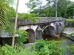 The bridge in 2017.
 -
 Bridge rededication plaque.
 -
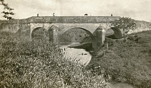 The bridge in 1911.


See also[edit]
References[edit]
- ^ NATIONAL PARK SERVICE, NATIONAL REGISTER DIGITAL ASSETS (1995). "Rio Piedras Bridge". npgallery.nps.gov.
- ^ Pumarada O'Neill, Luis (July 31, 1994). "NATIONAL REGISTER OF HISTORIC PLACES REGISTRATION FORM". npgallery.nps.gov.

This article about a property in Puerto Rico on the National Register of Historic Places is a stub. You can help Wikipedia by expanding it. |
- Bridges completed in 1853
- Historic American Engineering Record in Puerto Rico
- National Register of Historic Places in San Juan, Puerto Rico
- Road bridges on the National Register of Historic Places in Puerto Rico
- Transportation in San Juan, Puerto Rico
- 1853 establishments in Puerto Rico
- Puerto Rico Registered Historic Place stubs