
Rechtsupweg
Rechtsupweg | |
|---|---|
 Coat of arms | |
Location of Rechtsupweg within Aurich district 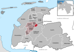 | |
 Rechtsupweg  Rechtsupweg | |
| Coordinates: 53°31′46″N 7°19′36″E / 53.52944°N 7.32667°E | |
| Country | Germany |
| State | Lower Saxony |
| District | Aurich |
| Municipal assoc. | Brookmerland |
| Government | |
| • Mayor | Karl-Edzard Walzer (SPD) |
| Area | |
| • Total | 5.13 km2 (1.98 sq mi) |
| Elevation | 1 m (3 ft) |
| Population (2022-12-31)[1] | |
| • Total | 2,116 |
| • Density | 410/km2 (1,100/sq mi) |
| Time zone | UTC+01:00 (CET) |
| • Summer (DST) | UTC+02:00 (CEST) |
| Postal codes | 26529 |
| Dialling codes | 04934 |
| Vehicle registration | AUR |
Rechtsupweg is a municipality in the district of Aurich, in Lower Saxony, Germany.
References[edit]
Towns and municipalities in Aurich (district) | ||
|---|---|---|
 | ||
| International | |
|---|---|
| National | |
This Aurich (district) location article is a stub. You can help Wikipedia by expanding it. |