
Ringtail Creek, Queensland
| Ringtail Creek Queensland | |||||||||||||||
|---|---|---|---|---|---|---|---|---|---|---|---|---|---|---|---|
 Ringtail Creek | |||||||||||||||
 | |||||||||||||||
| Coordinates | 26°20′24″S 152°57′04″E / 26.34°S 152.9511°E | ||||||||||||||
| Population | 197 (2016 census)[1] | ||||||||||||||
| • Density | 5.565/km2 (14.41/sq mi) | ||||||||||||||
| Postcode(s) | 4565 | ||||||||||||||
| Area | 35.4 km2 (13.7 sq mi) | ||||||||||||||
| Time zone | AEST (UTC+10:00) | ||||||||||||||
| Location |
| ||||||||||||||
| LGA(s) | Shire of Noosa | ||||||||||||||
| State electorate(s) | Noosa | ||||||||||||||
| Federal division(s) | Wide Bay | ||||||||||||||
| |||||||||||||||
Ringtail Creek is a rural locality in the Shire of Noosa, Queensland, Australia.[2] In the 2016 census Ringtail Creek had a population of 197 people.[1]
Geography[edit]
The locality is in the northern Sunshine Coast hinterland.
The north-eastern boundary follows the Noosa River where it leaves Lake Cootharaba. A small section in the west belongs to the Mary River catchment area. A large portion of the locality is protected within the Ringtail Forest Reserve.
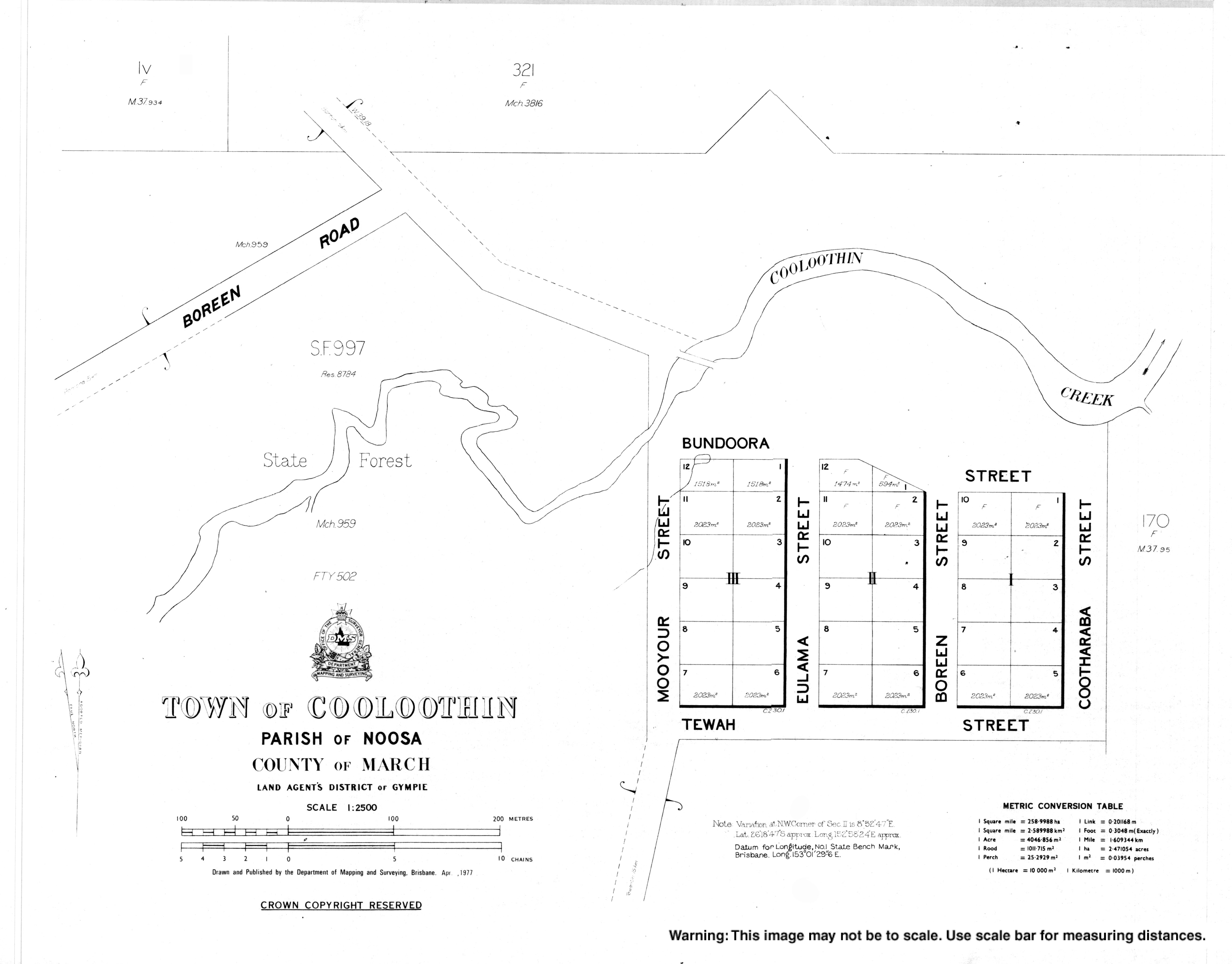
The town of Cooloothin is at 26°18′48″S 152°58′25″E / 26.3132°S 152.9735°E.[3][4]
Sealys Lagoon is a lagoon on Ringfield Creek (the watercourse) on the eastern border of the locality (26°20′08″S 152°59′31″E / 26.3355°S 152.9919°E).[5]
History[edit]
By 1875, a sugarcane plantation had been established at Cooloothin Creek by 1875.[6]
In July 1880, the Queensland Government sold off 61 town allotments in Cooloothin.[7] A few houses remain on the northern edge of the town but the southern part of the town is now Tewah Park.[8]
Ringtail State School opened on 1 May 1912 and closed on 1943.[9] It was located on the north-east corner of Gards Road and Ringtail Creek Road (approximately 26°20′57″S 152°56′01″E / 26.3493°S 152.9336°E), now the south-western corner of the Ringtail State Forest. The site is marked.[10][11][12][13][14]
Cooloothin Creek Provisional opened on 16 August 1915. On 1 May 1929 it became Cooloothin Creek State School. It closed in 1936.[9]
Between 2008 and 2013, Ringtail Creek (and the rest of the Shire of Noosa) was within Sunshine Coast Region.[15][16]
At the 2011 census Ringtail Creek had a population of 180 people.[17]
Sealys Lagoon was gazetted on 27 November 2015. It was named after Cyril Sealy (1905–1959), who purchased Portion 298, Parish of Noosa in 1947. In the 1930s and 1940s Cyril and his brother Albert were lifesaving volunteers Noosa Life Saving Club who patrolled the Noosa beaches to assist swimmers needing help. They also served as volunteer lifesaving instructors for the club. Other members of the Sealy family were active volunteers in the club and in other community groups.[5]
In the 2016 census Ringtail Creek had a population of 197 people.[1]
Education[edit]
There are no schools in Ringtail Creek. The nearest government primary schools are Tewantin State School in Tewantin to the south-east, Cooroy State School in Cooroy to the south, and Pomona State School in neighbouring Pomona to the south-west. The nearest government secondary school is Noosa District State High School which has its junior campus at Pomona and its senior campus at Cooroy.[14]
Amenities[edit]
There is a boat ramp and jetty at Bundoora Street (26°18′44″S 152°58′33″E / 26.3122°S 152.9757°E) providing access to Cooloothin Creek (a tributary of Lake Cootharaba. They are managed by the Noosa Shire Council.[18]
References[edit]
- ^ a b c Australian Bureau of Statistics (27 June 2017). "Ringtail Creek (SSC)". 2016 Census QuickStats. Retrieved 20 October 2018.
- ^ "Ringtail Creek – locality in Shire of Noosa (entry 48856)". Queensland Place Names. Queensland Government. Retrieved 28 December 2020.
- ^ "Cooloothin – population centre in Noosa Shire (entry 8144)". Queensland Place Names. Queensland Government. Retrieved 20 November 2020.
- ^ "Town of Cooloothin" (Map). Queensland Government. 1977. Archived from the original on 13 November 2020. Retrieved 13 November 2020.
- ^ a b "Sealys Lagoon – lagoon in Shire of Noosa (entry 49709)". Queensland Place Names. Queensland Government. Retrieved 28 December 2020.
- ^ "Noosa". The Brisbane Courier. Vol. XXX, no. 2, 671. Queensland, Australia. 11 December 1875. p. 7. Archived from the original on 8 March 2021. Retrieved 13 November 2020 – via National Library of Australia.
- ^ "LAND SALES". The Telegraph. No. 2, 352. Queensland, Australia. 29 May 1880. p. 2. Archived from the original on 8 March 2021. Retrieved 13 November 2020 – via National Library of Australia.
- ^ "Cooloothin". Google Maps (Maps). Archived from the original on 13 November 2020. Retrieved 13 November 2020.
- ^ a b Queensland Family History Society (2010), Queensland schools past and present (Version 1.01 ed.), Queensland Family History Society, ISBN 978-1-921171-26-0
- ^ "Site of Ringtail School, 1912-1943 (ca. 2004)". Sunshine Coast Libraries. Retrieved 25 October 2021.
- ^ Google (25 October 2021). "Marker for Ringtail State School" (Map). Google Maps. Google. Retrieved 25 October 2021.
- ^ "Cooroy" (Map). Queensland Government. 1942. Archived from the original on 28 December 2020. Retrieved 25 October 2021.
- ^ "Queensland Two Mile series sheet 2m76" (Map). Queensland Government. 1943. Archived from the original on 5 May 2021. Retrieved 25 October 2021.
- ^ a b "Queensland Globe". State of Queensland. Retrieved 25 October 2021.
- ^ "Backward Glance: History of Local Government on the Sunshine Coast". Sunshine Coast Regional Council. Retrieved 2 August 2023.
- ^ "The Noosa De-amalgamation: Building a New Organisation". Noosa Shire Council. 2 January 2014. pp. 8–9. Retrieved 2 August 2023.
- ^ Australian Bureau of Statistics (31 October 2012). "Ringtail Creek (State Suburb)". 2011 Census QuickStats. Retrieved 10 October 2014.
- ^ "Recreational Boating Facilities Queensland". Queensland Open Data. Queensland Government. 12 November 2020. Archived from the original on 22 November 2020. Retrieved 22 November 2020.