Slagharen
Slagharen | |
|---|---|
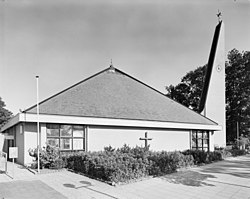
 The church of Slagharen | |
Location in province of Overijssel in the Netherlands | |
| Coordinates: 52°37′30″N 6°33′10″E / 52.6250°N 6.5527°E | |
| Country | Netherlands |
| Province | Overijssel |
| Municipality | Hardenberg |
| Area | |
| • Total | 12.07 km2 (4.66 sq mi) |
| Elevation | 9 m (30 ft) |
| Population (2021)[1] | |
| • Total | 3,125 |
| • Density | 260/km2 (670/sq mi) |
| Time zone | UTC+1 (CET) |
| • Summer (DST) | UTC+2 (CEST) |
| Postal code | 7776[1] |
| Dialing code | 0523 |
Slagharen is a village in the municipality of Hardenberg in the province of Overijssel, Netherlands. The village started as a peat excavation village. It is known for the Attractiepark Slagharen, an amusement park.
History[edit]
In 1832, the Lutterhoofdwijk canal was dug as a side canal of the Dedemsvaart to excavate the peat in the area and the village was established along the canal,[3] however, in 1830, a community of 81 people was recorded at the site. All except for a Frisian family were from neighbouring Germany, and were living in sod houses on the moorland.[4]
In 1844, the name Slagharen first appeared, and means "parcel [of land] on sandy ground".[5] The predominantly German settlers resulted in the founding of a Catholic church in 1843. The church was replaced in 1967.[3] In 1859, the gristmill De Pionier was built near the village.[6] In 1975, it was bought by the amusement park and restored.[7]
In 1952, Wehkamp, a mail order company, opened in Slagharen. It quickly developed into one of largest mail order companies of the Netherlands. In 1975, it moved to Zwolle, and is nowadays a large online shop.[8]
In 1963, the Ponypark Slagharen opened where you could stay in a holiday house with your own Shetland pony. In 1972, it turned into an amusement park.[9]
Notable people[edit]
- Chantal Beltman (born 1976), former professional cyclist[10]
- Gerard Nijkamp (born 1970) is a football player and manager[11]
Gallery[edit]
-
The ponies at the former ponypark
-
Social sofa in Slagharen
-
Windmill De Pionier
References[edit]
- ^ a b c "Kerncijfers wijken en buurten 2021". Central Bureau of Statistics. Archived from the original on 22 December 2021. Retrieved 14 March 2022.
- ^ "Postcodetool for 7776AA". Actueel Hoogtebestand Nederland (in Dutch). Het Waterschapshuis. Archived from the original on 24 December 2018. Retrieved 14 March 2022.
- ^ a b Ronald Stenvert & Jan ten Hove (1998). "Slagharen" (in Dutch). Zwolle: Waanders. p. 249. ISBN 90 400 9200 1. Archived from the original on 3 April 2016. Retrieved 14 March 2022.
- ^ "Het bevolkingsregister van buurtschap Slagharen 1830". Historisce Projecten (in Dutch). Archived from the original on 14 May 2021. Retrieved 14 March 2022.
- ^ "Slagharen - (geografische naam)". Etymolgiebank (in Dutch). Retrieved 14 March 2022.
- ^ "De Pionier". Molendatabase (in Dutch). Archived from the original on 11 January 2022. Retrieved 14 March 2022.
- ^ "Slagharen". Plaatsengids (in Dutch). Archived from the original on 5 February 2022. Retrieved 14 March 2022.
- ^ "De geschiedenis van Wehkamp". Vano ICT (in Dutch). Archived from the original on 14 March 2022. Retrieved 14 March 2022.
- ^ "Slagharen geschiedenis: Het avontuur vanaf 1963". Slagharen (in Dutch). Archived from the original on 13 June 2021. Retrieved 14 March 2022.
- ^ "Chantal Beltman". Cycling Archives. Archived from the original on 2 July 2020. Retrieved 14 March 2022.
- ^ "Gerard Nijkamp nieuwe technische directeur Sparta Rotterdam". RTV Oost (in Dutch). 17 December 2021. Retrieved 15 March 2022.


