Sloup v Čechách
Sloup v Čechách | |
|---|---|
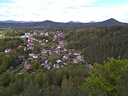
 View from the south | |
| Coordinates: 50°44′20″N 14°35′20″E / 50.73889°N 14.58889°E | |
| Country | |
| Region | Liberec |
| District | Česká Lípa |
| First mentioned | 1318 |
| Area | |
| • Total | 5.77 km2 (2.23 sq mi) |
| Elevation | 292 m (958 ft) |
| Population (2023-01-01)[1] | |
| • Total | 717 |
| • Density | 120/km2 (320/sq mi) |
| Time zone | UTC+1 (CET) |
| • Summer (DST) | UTC+2 (CEST) |
| Postal code | 471 52 |
| Website | www |
Sloup v Čechách (German: Bürgstein) is a municipality and village in Česká Lípa District in the Liberec Region of the Czech Republic. It has about 700 inhabitants. The area of the village is well preserved and is protected by law as a village monument zone.
Geography[edit]
Sloup v Čechách is located about 6 km (4 mi) northeast of Česká Lípa and 32 km (20 mi) west of Liberec. It lies in the Ralsko Uplands. The highest point the hill Slavíček at 535 m (1,755 ft) above sea level. In the southern part of the municipal territory there is a sandstone rock town.[2]
History[edit]
The first written mention of Sloup v Čechách is from 1318. There was a customs office on an old trade route from Prague to Zittau. In 1595, the Berka of Dubá family had a new manor house built. The greatest development of the village occurred after 1726, during the rule of Count Josef Jan Maxmilián Kinsky, who turned the estate into an important centre of industry and craft.[3]
From 1870, Sloup v Čechách became a holiday resort with a number of number of recreational facilities. After the World War II, the German population was expelled. From 1981 to 1990, Sloup v Čechách was an administrative part of Nový Bor.[3]
Demographics[edit]
|
|
| ||||||||||||||||||||||||||||||||||||||||||||||||||||||
| Source: Censuses[4][5] | ||||||||||||||||||||||||||||||||||||||||||||||||||||||||
Sights[edit]


Sloup v Čechách is known for the Sloup Castle. It is a rock castle on a 35 m (115 ft) high sandstone rock.[6]
Sloup Chateau was built by Count Kinsky in 1730–1733. Today the Baroque chateau serves as a retirement home.[7]
The Church of Saint Catherine of Alexandria was originally built in the 14th century. The current church was built in 1707–1719. A Marian column from 1694 stands in front of the church.[8]
There are many well-preserved half-timbered houses in the village.[8]
In popular culture[edit]
The fairytale film Give the Devil His Due was partly shot in the municipality.[6]
Notable people[edit]
- Ferdinand Břetislav Mikovec (1826–1862), writer and historian
Twin towns – sister cities[edit]
Sloup v Čechách is twinned with:[9]
 Stolpen, Germany
References[edit]
- ^ "Population of Municipalities – 1 January 2023". Czech Statistical Office. 2023-05-23.
- ^ "Sloupské skalní město" (in Czech). Sdružení Český ráj. Retrieved 2022-10-27.
- ^ a b "Historie" (in Czech). Obec Sloup v Čechách. Retrieved 2022-10-27.
- ^ "Historický lexikon obcí České republiky 1869–2011 – Okres Česká Lípa" (in Czech). Czech Statistical Office. 2015-12-21. pp. 13–14.
- ^ "Population Census 2021: Population by sex". Public Database. Czech Statistical Office. 2021-03-27.
- ^ a b "Skalní hrad a poustevna Sloup" (in Czech). CzechTourism. Retrieved 2022-10-27.
- ^ "Zámek" (in Czech). National Heritage Institute. Retrieved 2022-10-27.
- ^ a b "O obci Sloup v Čechách" (in Czech). Obec Sloup v Čechách. Retrieved 2022-10-27.
- ^ "Partnerschaften" (in German). Stadt Stolpen. Retrieved 2020-08-15.


