
South Norwalk Railroad Bridge
South Norwalk Railroad Bridge | |
|---|---|
 | |
| Coordinates | 41°05′56″N 73°25′08″W / 41.09889°N 73.41889°W |
South Norwalk Railroad Bridge | |
  | |
| Location | Main and Washington Streets Norwalk, Connecticut |
| Coordinates | 41°05′56″N 73°25′08″W / 41.09889°N 73.41889°W |
| Area | 5.5 acres (2.2 ha) (original) 2.5 acres (1.0 ha) (increase I) 3 acres (1.2 ha) (increase II) |
| Built | 1895 |
| Part of | South Main and Washington Streets Historic District (ID77001393, 85003505, and 99000449[1]) |
| Added to NRHP | December 16, 1977 (original) November 8, 1985 (increase I) April 15, 1999 (increase II) |
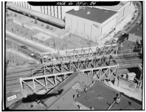
| Carries | 4 tracks of New Haven Line |
| Characteristics | |
| Design | through Pratt truss |
| Clearance below | 3.38 metres (11 ft 1 in) |
| History | |
| Constructed by | NY, NH&H RR |
| Opened | 1895 |
| Location | |
 | |
The South Norwalk Railroad Bridge is an 1895 bridge in Norwalk, Connecticut. It carries the four sets of Metro-North railroad tracks across the busy intersection of Main Street and Washington Street in the South Norwalk section of the city. The bridge is adjacent to the South Norwalk Switch Tower Museum, which showcases the railroad switch tower where tracks were physically switched at the intersection of the Danbury Branch and the New Haven Line.
The bridge is a contributing structure in the South Main and Washington Streets Historic District.[2]
-
 Unusual building adjacent to northeast corner of bridge with partial view of bridge on right, 12 August 2007
 -
 The Switch Tower Museum, 12 August 2007
 -
 1910 postcard view along Washington Street with the bridge behind the trolley


References[edit]
- ^ "National Register Information System". National Register of Historic Places. National Park Service. March 13, 2009.
- ^ Bruce Clouette (March 28, 1977). "National Register of Historic Places Inventory-Nomination: South Main & Washington Street". National Park Service. and Accompanying 13 photos, from 1977
External links[edit]
- Historic American Engineering Record (HAER) No. CT-168, "South Norwalk Railroad Bridge, South Main & Washington Streets, Norwalk, Fairfield County, CT", 21 photos, 11 data pages, 4 photo caption pages
- SoNo Switch Tower Museum
Categories:
- Bridges completed in 1895
- Railroad bridges in Connecticut
- Bridges in Fairfield County, Connecticut
- Buildings and structures in Norwalk, Connecticut
- Historic district contributing properties in Connecticut
- Historic American Engineering Record in Connecticut
- National Register of Historic Places in Fairfield County, Connecticut
- Railroad bridges on the National Register of Historic Places in Connecticut
- Pratt truss bridges in the United States
- Metal bridges in the United States