
Stathern
| Stathern | |
|---|---|
 Stathern Location within Leicestershire | |
| Population | 728 (2011 Census) |
| District | |
| Shire county | |
| Region | |
| Country | England |
| Sovereign state | United Kingdom |
| Post town | MELTON MOWBRAY |
| Postcode district | LE14 |
| Police | Leicestershire |
| Fire | Leicestershire |
| Ambulance | East Midlands |
| UK Parliament | |
Stathern is an English village and civil parish in the Melton district of Leicestershire. It lies in the Vale of Belvoir about 10 miles (16 km) north of Melton Mowbray. Its church has an unusual dedication and its school a long history. Its pub doubles as a post office.
Population[edit]
In the 2001 census the parish had 288 dwellings,[1] and a population of 672.[2] The population had increased to 728 at the time of the 2011 census,[3] and was estimated at 751 in 2019.[4]
Amenities[edit]
The village has an Anglican church, St Guthlac's, listed Grade II*. Parts of it date from the 13th and 17th centuries. It was restored in 1867–1868 under R. W. Johnson.[5] Guthlac of Crowland was a Lincolnshire hermit-saint of the 7th–8th century. The church has a ring of five bells. It normally holds a family service on the first Sunday in the month.[6]
The village primary school in Water Lane dates back at least to 1868 and in some form to 1845.[7] It has about 100 pupils.[8]
The public house, The Plough Inn, also acts as a restaurant and provides thrice-weekly post office services.[9] There coffee shop, village store[10] and bed-and-breakfast accommodation available in the village.[11]
Stathern is served by hourly weekday, daytime buses between Melton Mowbray and Bottesford or Bingham.[12] The nearest railway station is at Bottesford (8 miles/12.9 km), with services to and beyond Nottingham and Grantham or Skegness.
-
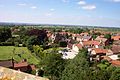
 View of Stathern looking South from the roof of St Guthlac's Church
 -
 View of Stathern looking North from the roof of St Guthlac's Church
 -
 St Guthlac's Church
 -
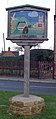
 Signpost in Stathern
 -
 Signpost in Stathern


.jpg)
.jpg)
References[edit]
- ^ "2001 Census: Key Statistics: Parish Profile – Accommodation and Tenure: Area: Stathern CP (Parish)". Neighbourhood Statistics. Office for National Statistics. Retrieved 21 November 2009.
- ^ "2001 Census: Key Statistics: Parish Headcounts: Area: Stathern CP (Parish)". Neighbourhood Statistics. Office for National Statistics. Retrieved 21 November 2009.
- ^ "Civil Parish population 2011". Neighbourhood Statistics. Office for National Statistics. Retrieved 21 June 2016.
- ^ City Population. Retrieved 3 February 2021.
- ^ Listing text. Retrieved 22 April 2019.
- ^ Stathern pages. Retrieved 22 April 2019.
- ^ School's own site. Retrieved 22 April 2019.
- ^ Ofsted reports.
- ^ Own site. Retrieved 18 April 2019.
- ^ "COFFEE SHOT | STATHERN | CAFE & SHOP". coffee-shot. Retrieved 24 February 2023.
- ^ Parish Council site. Retrieved 22 April 2019.
- ^ Bus times. Retrieved 18 April 2019.
External links[edit]
![]() Media related to Stathern at Wikimedia Commons
Media related to Stathern at Wikimedia Commons
52°52′20.2″N 0°51′15.3″W / 52.872278°N 0.854250°W
This Leicestershire location article is a stub. You can help Wikipedia by expanding it. |