Sterling Ranch, Colorado
Sterling Ranch, Colorado | |
|---|---|
 Sterling Ranch | |
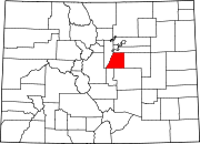
Location of the Sterling Ranch CDP in the State of Colorado. | |
| Coordinates: 39°29′36″N 105°02′51″W / 39.4932274°N 105.0475076°W[1] | |
| Country | |
| State | |
| County | Douglas County |
| Government | |
| • Type | unincorporated community |
| Area | |
| • Total | 5.529 sq mi (14.320 km2) |
| • Land | 5.529 sq mi (14.320 km2) |
| • Water | 0.000 sq mi (0.000 km2) |
| Elevation | 5,712 ft (1,741 m) |
| Population | |
| • Total | 1,789 |
| • Density | 320/sq mi (120/km2) |
| Time zone | UTC-7 (MST) |
| • Summer (DST) | UTC-6 (MDT) |
| ZIP Code[4] | Littleton 80125 |
| Area codes | 303 & 720 |
| GNIS feature[2] | Sterling Ranch CDP |
Sterling Ranch is an unincorporated community and a census-designated place (CDP) located in and governed by Douglas County, Colorado, United States. The population was 1,789 at the 2020 census.[3] The CDP is a part of the Denver–Aurora–Lakewood, CO Metropolitan Statistical Area. Douglas County governs the unincorporated community and the Sterling Ranch Community Authority Board provides services through several metropolitan districts. The Littleton post office (Zip Code 80125) serves the area.[4]
History[edit]
Construction of Sterling Ranch development began in early 2016, with eight builders offering single-family homes. The development comprises 3,400 acres and was to eventually house 33,000 residents.[5] The full buildout for the community is projected to take 20 years and will include nine villages with a town center.
Sterling Ranch will include 30 miles of internal trails connecting to Chatfield State Park and Roxborough State Park and three regional parks. Nearly 40 percent of Sterling Ranch will remain open space, including two wildlife corridors.
Providence Village, the first of the nine villages in the development, consists of just under 800 homes, a recreation center, church, school, civic center, and several parks.
Geography[edit]
The Sterling Ranch CDP has an area of 3,539 acres (14.320 km2), all land.[1]
Demographics[edit]
The United States Census Bureau defined the Sterling Ranch CDP for the United States Census 2020.
| Year | Pop. | ±% |
|---|---|---|
| 2020 | 1,789 | — |
| Source: United States Census Bureau | ||
Education[edit]
The Douglas County School District RE-1 serves Sterling Ranch.
Water[edit]
Sterling Ranch is served by the Dominion Water and Sanitation District, which was building a water system with a water treatment facility on Sterling Ranch.
Technology[edit]
Sterling Ranch is Colorado’s first 1 Gig community.[6] Every home has fiber optic lines running directly to it.[7]
See also[edit]
- Outline of Colorado
- State of Colorado
References[edit]
- ^ a b c "State of Colorado Census Designated Places - BAS20 - Data as of January 1, 2020". United States Census Bureau. Retrieved December 21, 2020.
- ^ a b c "U.S. Board on Geographic Names: Domestic Names". United States Geological Survey. Retrieved December 21, 2020.
- ^ a b United States Census Bureau. "Sterling Ranch CDP, Colorado". Retrieved April 9, 2023.
- ^ a b "Zip Code 80125 Map and Profile". zipdatamaps.com. 2020. Retrieved December 21, 2020.
- ^ "Douglas County approves long-contested Sterling Ranch development". May 11, 2011.
- ^ "Abbot: 8083 Mount Ouray Road" (PDF).
- ^ "Abbot: 8083 Mount Ouray Road" (PDF).


