
Stockport Town Hall
| Stockport Town Hall | |
|---|---|
 Stockport Town Hall | |
 | |
| General information | |
| Architectural style | English Baroque style |
| Classification | |
Listed Building – Grade II* | |
| Designated | 10 March 1975 |
| Reference no. | 1067166 |
| Town or city | Stockport, Greater Manchester |
| Country | United Kingdom |
| Coordinates | 53°24′21″N 2°9′31″W / 53.40583°N 2.15861°W |
| Inaugurated | 1908 |
| Owner | Stockport Metropolitan Borough Council |
| Height | 40 m (130 ft) |
| Design and construction | |
| Architect(s) | Sir Alfred Brumwell Thomas |
Stockport Town Hall is a building in Stockport, Greater Manchester, England, that houses the government and administrative functions of Stockport Metropolitan Borough Council. Stockport Town Hall is a Grade II* listed building.[1]
History[edit]
The building, which was designed by the architect Sir Alfred Brumwell Thomas in the English Baroque style, was opened by the then Prince and Princess of Wales on 7 July 1908.[1] To commemorate the Royal visit, part of Heaton Lane, a main shopping street in the town, was renamed Prince's Street.[2][3][4]
The ballroom in the town hall served as a hospital during the First World War and was used as a home for refugees from the Channel Islands during the Second World War.[5]
The town hall, which had served as the headquarters of the county borough of Stockport for much of the 20th century, continued to be the local seat of government after the enlarged Stockport Metropolitan Borough Council was formed in 1974.[6]
Description[edit]
The chamber is decorated with elaborate plasterwork, brass chandeliers and decorative carvings on oak benches.[7] The civic collection of silver, some of which dates from the 15th century, lines the wall of the corridor outside the chamber.[7]
An imposing Italian marble entrance leads to the Edwardian Ballroom, which former poet laureate Sir John Betjeman described as "magnificent".[8]
The ballroom has a Wurlitzer Publix One theatre organ with four manuals and 20 ranks of pipes, specified by Jesse Crawford.[9] It was originally installed in the Paramount Cinema on Oxford Road in Manchester in 1930; it had been planned to install one of these in each of the 50 Paramount theatres, however this was the only one to be installed, and the only one of that model to leave the United States. When the theatre was divided, the organ was acquired by the Lancastrian Theatre Organ Trust, loaned to the city of Manchester and relocated to the Free Trade Hall (a process taking four years); and was first used there in September 1977. When the Free Trade Hall closed, it was moved to Stockport Town Hall in 1999.[10][11]
The town hall, which as the home of Stockport Symphony Orchestra, hosts classical concerts on a regular basis,[12] has been nicknamed "the wedding cake".[4]
Gallery[edit]
-
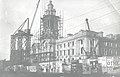 Stockport Town Hall under construction c.1907
 -
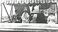 The Prince and Princess of Wales at the opening of Stockport Town Hall
 -
 Stockport Town Hall
 -
 Stockport Town Hall, main entrance
 -
 Stockport Town Hall
 -
 Stockport Town Hall
 -
 Front façade of Stockport Town Hall


.jpg)


See also[edit]
References[edit]
- ^ a b Historic England. "Town Hall (1067166)". National Heritage List for England. Retrieved 9 May 2016.
- ^ Arrowsmith, Peter (1997). Stockport: a History. Stockport: Stockport Metropolitan Borough Council. p. 246. ISBN 0-905164-99-7.
- ^ Pevsner, Nikolaus (1971). The Buildings of England: Cheshire. London: Penguin. p. 341. ISBN 0-14-071042-6.
- ^ a b "Town Hall (2005)". Stockport Metropolitan Borough Council. Archived from the original on 28 September 2011. Retrieved 14 April 2014.
- ^ "Stockport Town Hall celebrates centenary". Cheshire Life. 14 January 2010. Retrieved 9 August 2020.
- ^ Local Government Act 1972. 1972 c.70. The Stationery Office Ltd. 1997. ISBN 0-10-547072-4.
- ^ a b Littlechilds, Ian; Page, Phil (2017). Secret Stockport. Amberley Publishing. ISBN 978-1445651361.
- ^ "Stockport Town Hall". Archiseek. Retrieved 11 April 2020.
- ^ "Stockport Town Hall". Cinema Organs. Retrieved 9 August 2020.
- ^ "Stockport". Lancastrian Theatre Organ Trust. Retrieved 9 August 2020.
- ^ "About Lancastrian Theatre Organ Trust - Stockport". Organfx. Retrieved 11 April 2020.
- ^ "Stockport Symphony Orchestra". Stockport Metropolitan Borough Council. Retrieved 11 April 2020.
53°24′21″N 2°9′31″W / 53.40583°N 2.15861°W


