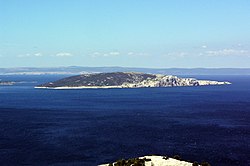
Sveti Grgur
 Map of Sveti Grgur | |
 | |
| Geography | |
|---|---|
| Location | Adriatic Sea |
| Area | 6.37 km2 (2.46 sq mi) |
| Highest elevation | 226 m (741 ft) |
| Highest point | Štandarac |
| Administration | |
| Demographics | |
| Population | 0 |
Sveti Grgur (Croatian pronunciation: [svȇtī gr̂guːr], Italian: San Gregorio; lit. Saint Gregory) is an uninhabited island in Croatia, on the Adriatic Sea between Rab and Krk. The island was the site of a women's prison in SFR Yugoslavia, in tandem with nearby Goli Otok which served the same purpose for men, from 1949 to 1980.[1]
See also[edit]
Literature[edit]
- Milutin Popović, Sećanja na logor Sveti Grgur. Symix graphics, Beograd, 1991.
- Ženi Lebl, LJUBIČICA BELA-White Violete with the subtitle "Two and half years in the Yugoslav Gulag for women", Belgrade, 2009
References[edit]
- ^ "GOLI OTOK PRISON CAMP". Balkan History. Retrieved 2023-12-22.
External links[edit]
 Media related to Sveti Grgur at Wikimedia Commons

