
Týnec (Klatovy District)
Týnec | |
|---|---|
 Týnec Castle | |
 Flag  Coat of arms | |
 Týnec Location in the Czech Republic | |
| Coordinates: 49°20′15″N 13°29′26″E / 49.33750°N 13.49056°E | |
| Country | |
| Region | Plzeň |
| District | Klatovy |
| First mentioned | 1227 |
| Area | |
| • Total | 7.48 km2 (2.89 sq mi) |
| Elevation | 507 m (1,663 ft) |
| Population (2023-01-01)[1] | |
| • Total | 362 |
| • Density | 48/km2 (130/sq mi) |
| Time zone | UTC+1 (CET) |
| • Summer (DST) | UTC+2 (CEST) |
| Postal codes | 340 21 |
| Website | www |
Týnec is a municipality and village in Klatovy District in the Plzeň Region of the Czech Republic. It has about 400 inhabitants.
Týnec lies approximately 6 kilometres (4 mi) south of Klatovy, 46 km (29 mi) south of Plzeň, and 117 km (73 mi) south-west of Prague.
Administrative parts[edit]
The villages of Horní Lhota, Loreta and Rozpáralka are administrative parts of Týnec.
Demographics[edit]
| Year | Pop. | ±% |
|---|---|---|
| 1869 | 634 | — |
| 1880 | 712 | +12.3% |
| 1890 | 643 | −9.7% |
| 1900 | 647 | +0.6% |
| 1910 | 689 | +6.5% |
| 1921 | 721 | +4.6% |
| 1930 | 596 | −17.3% |
| 1950 | 457 | −23.3% |
| 1961 | 489 | +7.0% |
| 1970 | 454 | −7.2% |
| 1980 | 374 | −17.6% |
| 1991 | 310 | −17.1% |
| 2001 | 308 | −0.6% |
| 2011 | 304 | −1.3% |
| 2021 | 329 | +8.2% |
| Source: Censuses[2][3] | ||
Gallery[edit]
-
 Church of the Assumption of the Virgin Mary
 -
 Side street
 -
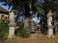 Crucifix and statues of St. John of Nepomuk and Virgin Mary Immaculate

,_ulice.jpg)

References[edit]
- ^ "Population of Municipalities – 1 January 2023". Czech Statistical Office. 2023-05-23.
- ^ "Historický lexikon obcí České republiky 1869–2011 – Okres Klatovy" (in Czech). Czech Statistical Office. 2015-12-21. pp. 29–30.
- ^ "Population Census 2021: Population by sex". Public Database. Czech Statistical Office. 2021-03-27.
External links[edit]
Wikimedia Commons has media related to Týnec (Klatovy District).
| Authority control databases: National |
|---|
This Plzeň Region location article is a stub. You can help Wikipedia by expanding it. |