
Talk:British Columbia Highway 7
| This article is rated Start-class on Wikipedia's content assessment scale. It is of interest to the following WikiProjects: | |||||||||||||||||||||||||||||||||||||||||||||
| |||||||||||||||||||||||||||||||||||||||||||||


Highway 7 Western End Point & Gap[edit]
Highway 7 certainly continues into Burnaby as far as boundary, but there are conflicting map reports as to whether broadway is part of highway 7, this map for instance doesn't contain it: http://www.drivebc.ca/map.jsp?mapId=325260343&viewFinderMapId=0&navMode=&scale=500000&mapImageX=151&mapImageY=249&eventId=&district=&ferry=on&camera=on&planned=on¤t=on&roadConditions=on&trafficIncidents=on&chkbxRoadConditions=on&chkbxTrafficIncidents=on&chkbxCurrent=on&chkbxPlanned=on&chkbxCamera=on&chkbxFerry=on , however the MOT http://www.th.gov.bc.ca/publications/planning/numbered_routes.htm#7, gives "The Greater Vancouver Transportation Authority (TransLink) has jurisdiction from the point east of Ottawa Street to the point east of United Blvd, and for the portion of the Lougheed Highway from Coleman Ave to Kingsway, via Broadway in Vancouver." I think this article should be changed SJrX10 (talk) 23:12, 24 July 2009 (UTC)
Finally the picture of Brentwood Station makes no sense, if the Highway ends in Coquitlam
There is also no gap as pictured in the map SJrX10 (talk) 05:17, 25 July 2009 (UTC)
- It's simply stating that TransLink has authority over the portion of Lougheed Highway past Coleman Avenue and the gap. The part that Translink has authority over is not a provincial highway as it is not maintained by the MOT, see Knight Street for an example of a freeway that's maintained by Translink, but not the MOT. єmarsee • Speak up! 21:16, 26 July 2009 (UTC)
- I believe that the signage is in place atleast as far as Boundary @ Broadway is still signed as BC Highway 7, unlike BC Highway 1A, the Old Fraser Highway, where it has lost the signage. I believe signage should be the test, as most maps, including the MOTs put Highway 7 atleast to Boundary. I don't think that the adminstrators of the highway is very relevant to it's inclusion here. I'd imagine that some other highways in BC that go through towns have some portions administered by a local authority, and that these wouldn't warrant gaps either. SJrX10 (talk) 21:26, 27 July 2009 (UTC)
- Here is a map from the MOT to the effect above http://www.th.gov.bc.ca/popular-topics/maps/2105-02.jpg SJrX10 (talk) 22:35, 27 July 2009 (UTC)
- Finally "The City of Vancouver has jurisdiction from the north end of the Oak Street Bridge to the south end of Stanley Park causeway (east end of Georgia Street at Chilco Street, 2.3 km south of the Lions Gate Bridge)." But the Highway 99 article includes the entire length, including this portion. SJrX10 (talk) 23:30, 27 July 2009 (UTC)
- I believe I saw new signs for Highway 99A and 1A on Kingsway, which doesn't make sense as Highway 99A doesn't exist anymore. Unlike Highway 99, the MOT clearly states that "From the junction with Route 1 near Hope, westward through Kent, Mission, Maple Ridge and Pitt Meadows to a point 95 metres east of Ottawa Street in Port Coquitlam. Then beginning again at a point 300 metres east of United Boulevard, westward and terminating at the onramp to Route 1 westbound, near Coleman Ave.", there is clearly a gap. The MOT does not mention a gap in their description of Highway 99.
- Finally "The City of Vancouver has jurisdiction from the north end of the Oak Street Bridge to the south end of Stanley Park causeway (east end of Georgia Street at Chilco Street, 2.3 km south of the Lions Gate Bridge)." But the Highway 99 article includes the entire length, including this portion. SJrX10 (talk) 23:30, 27 July 2009 (UTC)
- I suspect that it is simply a poor a choice in words, as I can't find anything that suggests the portions in between lost it's designation. Some of the maps above do mention highway 99A, so I suspect they are out of date, and can't be used as justification, either way. The Highway Planning Publication department published: http://www.th.gov.bc.ca/publications/planning/Provincial%20Highways/BC_Numbered_Hwy_Functional_Classes_with_Overview_2006-08-02.xls, which has the divisions you describe, however clearly states (under Secondary Hwys), "TransLink operates the other sections of Highway 7 west of the Pitt River". Highway 99A is not included anywhere in the spread sheet. The Accompanying map, also makes no mention of Highway 99A, but has Highway 7 continuous to what I imagine is Coleman http://www.th.gov.bc.ca/publications/planning/Provincial%20Highways/Func_Class_Map_20060601.pdf. One thing to keep in mind here is that this is a functional map, and Highway 99 through Vancouver proper is not included, but is clearly a highway. SJrX10 (talk) 06:18, 28 July 2009 (UTC)
- The map makes me believe that Highway 7B is now Highway 7 and it continues up United Boulevard. However that isn't true as Highway 7B still exists and will be upgraded to a freeway in the future. The gap is debatable, however as far as I know, Highway 7 past Coleman Avenue was downgraded to local authorities or Translink. I have Vancouver maps from Mapart from 2000 and 2008. The 2000 version has Highway 7 to Kingsway, the 2008 version has Highway 7 to the Cape Horn interchange. Quite frankly, it doesn't make sense for Highway 7 to end at Kingsway anymore since Highway 99A is gone and 1A is now just a short route from Downtown to Highway 1. єmarsee • Speak up! 16:40, 28 July 2009 (UTC)
- I agree I don't think that Highway 7 continues as far as Boundary and Kingsway, however I do think that Lougheed to Boundary is a much mor natural and expected end to BC Highway 7, especially because there is conflicting reports. The gaps here don't seem to relate to resident experiances or expectations, and the Ministry of Transportation seems to have conflicting views on where BC Highway 7 ends. I confess that I'm not sure what the next step for us is. SJrX10 (talk) 20:31, 28 July 2009 (UTC)
I think this is wrong.[edit]
Okay in the article it states that Lougheed begins again after Ottawa St. Not so, I say, not so. Lougheed essentially 'begins' at the corners of Johnson, Barnet, Lougheed and Lougheed. Basically, if you were coming Northbound on the Lougheed, you would have to take a right turn at Barnet (across from Coquitlam centre mall) to continue on Lougheed. If you went straight you would be on Johnson. It is at that point that if you were coming East Bound, on the Barnet, that the Barnet ceases, and the Lougheed begins. Consequently, I think that the map is wrong, and in fact the whole article is wrong, because highway 7 is actually continuous and not terminal in coquitlam. TotallyTempo (talk) 03:45, 14 May 2009 (UTC)
Furthermore[edit]
Lougheed runs all through out Burnaby, and I think highway 7 actually carries on as Broadway, though I'm not sure of that. In short, this whole entire article is wrong, because I am very very very sure one can drive on highway 7 all the way to Vancouver, from Hope, without using a road that is not indeed, highway 7. —Preceding unsigned comment added by TotallyTempo (talk • contribs) 03:49, 14 May 2009 (UTC)
==Reverted== I reverted to a version in Feb 2009, before someone suggested that there is two versions of this highway that aren't connected. This is simply false and untrue. I don't know what more to say, if you have a problem with this leave me a msg and we will sort it out. TotallyTempo (talk) 04:02, 14 May 2009 (UTC)
This isn't right.[edit]
Route 7 begins at Broadway and Granville in Vancouver. It goes east where at Cassiar, where the Vancouver portion of Broadway ends and it goes onto Lougheed Highway. There is no connection between Route 7 and Route 1 where they cross. Route 7 follows Lougheed Highway until its termination in Hope at Route 1.
Between Chilliwack and Hope it is also called the Haig Highway.
This isn't right.[edit]
Route 7 begins at Broadway and Granville in Vancouver. It goes east where at Cassiar, where the Vancouver portion of Broadway ends and it goes onto Lougheed Highway. There is no connection between Route 7 and Route 1 where they cross. Route 7 follows Lougheed Highway until its termination in Hope at Route 1.
Between Chilliwack and Hope it is also called the Haig Highway. 99.199.35.58 (talk) 01:36, 2 June 2009 (UTC)
- See the MOT's website, the highway is now in two sections. It ran from Kingsway to Haig before the change in 2006. єmarsee • Speak up! 01:41, 2 June 2009 (UTC)
I see it now. That is so very odd. I'll check to see if the route signs are still up though. Perhaps then, there ought to be a separate article on Lougheed Highway (and Haig for that matter). 99.199.35.58 (talk) 02:10, 3 June 2009 (UTC)
- For whatever reason, the MOT inserted new signs for Highway 99A/1A on Kingsway in Vancouver complete with reflective backing. I remember them not being there in 2007. I think all of the Highway signs are still up, even though it doesn't exist anymore. єmarsee • Speak up! 03:50, 3 June 2009 (UTC)
What is going on here?[edit]
This isn't rocket science, guys. Highway 7 begins at Broadway and Granville. There's a million signs on Broadway to indicate this, not to mention a "Junction Ahead" sign on Granville Street. This whole highway stopping and restarting is silly. That's merely where local authorities take over from provincial authorities. And for the record, no part of United Blvd is 7b or signed as such. The only connection between 7b and 7 is at the Pitt River Bridge. This will change when the new Cape Horn interchange is built.
Oh and Highway 7's only exit in Burnaby is located at Kensignton Avenue. I'm unsure of the number. The next official exits are at United Boulevard, then at Coast Meridian (once it's finished) and the next one is at the Pitt River Bridge with 7b.
Can someone straighten this article out? —Preceding unsigned comment added by 24.86.118.7 (talk) 09:50, 2 October 2009 (UTC)
- Why should I even care about signs? There's new signs for BC 99/1A on Kingsway, but 99A doesn't even exists anymore and 1A doesn't exist past the Lions Gate Bridge. The fact is, BC7 stops at metres before Ottawa Street and then restarts for a short portion at the Cape Horn interchange. To say that I don't have any idea what I'm talking about is absurd, I've been on Broadway many times and I know the new signs. Doesn't mean it's still Highway 7. End of story. єmarsee • Speak up! 03:15, 3 October 2009 (UTC)
- Here's a source. Believe what you want to believe, but you're only deluding yourself. http://www.translink.ca/en/Driving/Highways/Highway-7-Lougheed.aspx 24.86.118.7 (talk) 03:56, 5 October 2009 (UTC)
- Seriously? That's the best you've got? You've just contradicted yourself, you've stated it starts at Granville and this states it startes at the Van/Bby border. The BCMOT is the only official source regarding where provincial highway start, you're getting nowhere fast. єmarsee • Speak up! 04:08, 5 October 2009 (UTC)
- Highway 7 does not stop and restart. Quit trying to own the article. I've provided an official source on this highway. That source you have only tells one where provincial responsibility begins and ends. 24.86.118.7 (talk) 04:15, 5 October 2009 (UTC)
- Quit trying to provide incorrect information. TransLink is not an official source as they are NOT responsible for provincial highway. There's a reason why they call it a provincial highway. єmarsee • Speak up! 04:23, 5 October 2009 (UTC)
- That's kind of the idea. They may not be responsible but that doesn't change a highway's designation. Lougheed Highway IS Route 7 from at least Boundary eastward. TransLink assumes responsibility as such. The case is the same in the USA with interstates. Several interstates are managed at the local or county level but they are still interstates. How is this any different? 24.86.118.7 (talk) 04:30, 5 October 2009 (UTC)
- Highway 7 doesn't even exist past the Cape Horn interchange. Highway 7's designation has been dropped officially past the Cape Horn interchange. The gap clearly exists as the MOT clearly states it stops near the United Blvd interchange and restarts at Ottawa Street. The only expressways under Translink's jurisdiction is the Golden Ears Way and Knight Street. єmarsee • Speak up! 04:33, 5 October 2009 (UTC)
- You're regurgitating what we know you've been trying to claim for the last few days. Do you have a specific response to my last query? 24.86.118.7 (talk) 04:36, 5 October 2009 (UTC)
- TransLink doesn't manage Highway 7, it never did. It only maintains the sections of Lougheed Highway that are not part of Highway 7. The link you provided doesn't even mention TransLink maintains the section of Lougheed Highway. єmarsee • Speak up! 04:40, 5 October 2009 (UTC)
- Ah, but your argument is falling apart fast. Okay, TransLink does not manage Lougheed Highway, but it doesn't change the fact that the signage is there. The city obviously acknowledges it as such. Why does the fact that a road is locally managed change its designation? An identical situation exists with certain portions of interstates. I ask again, how is this any different? 24.86.118.7 (talk) 04:48, 5 October 2009 (UTC)
- So? Does it matter if they installed new signs? There's new signs for Highway 99A/1A on Kingsway. Doesn't mean 99A or 1A exists on Kingsway. Signs for 7A still exists on the Barnet Highway, but it doesn't mean it's still signed as 7A. Translink does NOT manage Highway 7, it only manages the Lougheed Highway in the sections where the Highway 7 designation has been dropped. єmarsee • Speak up! 04:53, 5 October 2009 (UTC)
- It matters quite a bit. The city of Burnaby obviously considers its portion of Lougheed Highway to be route 7. And about Hastings Street and route 7a, the same technically applies there. The link you've been using states "The Greater Vancouver Transportation Authority (TransLink) has jurisdiction from the point east of Ottawa Street to the point east of United Blvd, and for the portion of the Lougheed Highway from Coleman Ave to Kingsway, via Broadway in Vancouver." Why even mention that? Here's why, because it's local responsibility. That doesn't mean that it's not route 7 anymore. It's simply locally run. The BC MOT did not break the highway up like that. BC MOT is saying that it goes to Kingsway and various maps tend to agree with that statement. If signage doesn't matter, then I'll simply phone Vancouver and Burnaby city halls and let them know said signs are in error. I don't think they'll agree. 24.86.118.7 (talk) 05:06, 5 October 2009 (UTC)
- I could'nt care less what the City of Burnaby considers to be a provincial highway. Only the MOT decides where provincial highways exist. There are still very old signs in New Westminster that still have the Highway 99A/1A on them. Doesn't mean it still exists. Why they installed new signs, I don't know. My 2008 edition MapArt GVRD map has Highway 7 going right up to the Cape Horn interchange, and removed all of Highway 7A and 99A. Highway 7 past the Cape Horn doesn't exist anymore since 2006, I know it's wrong, MapArt knows it's wrong, you're the only one who's arguing that it still goes to Kingsway. All that quote is stating is TransLink has jurisdiction of those parts of the Lougheed, why would the MOT state it ends and then restarts when you believe it doesn't? єmarsee • Speak up! 05:18, 5 October 2009 (UTC)
- "From the junction with Route 1 near Hope, westward through Kent, Mission, Maple Ridge and Pitt Meadows to a point 95 metres east of Ottawa Street in Port Coquitlam. Then beginning again at a point 300 metres east of United Boulevard, westward and terminating at the onramp to Route 1 westbound, near Coleman Ave." Why even mention it begins again when there's no gap? єmarsee • Speak up! 05:20, 5 October 2009 (UTC)
- Because that's a description of what the BC MOT is responsible for. The responsibility begins again at a point 300 metres east of United Boulevard. 24.86.118.7 (talk) 05:28, 5 October 2009 (UTC)
- Yes that's exactly what it is. Highway 7 doesn't exist 300 m E of United Blvd or 95 m E of Ottawa St. єmarsee • Speak up! 05:33, 5 October 2009 (UTC)
- Your source is a declaration of responsibility, it is specifically stating that TransLink is responsible for route 7: "The Greater Vancouver Transportation Authority (TransLink) has jurisdiction from the point east of Ottawa Street to the point east of United Blvd, and for the portion of the Lougheed Highway from Coleman Ave to Kingsway, via Broadway in Vancouver." Route 7 does not start and stop. This quote directly implies this.24.86.118.7 (talk) 05:36, 5 October 2009 (UTC)
- Having jurisdiction means nothing about the true route the Highway takes. TransLink is responsible for these sections, but it doesn't mean it's Highway 7. єmarsee • Speak up! 05:40, 5 October 2009 (UTC)
- TransLink seems to think so. http://www.translink.ca/en/Driving/Highways/Highway-7-Lougheed.aspx 24.86.118.7 (talk) 05:42, 5 October 2009 (UTC)
- Having jurisdiction means nothing about the true route the Highway takes. TransLink is responsible for these sections, but it doesn't mean it's Highway 7. єmarsee • Speak up! 05:40, 5 October 2009 (UTC)
- Your source is a declaration of responsibility, it is specifically stating that TransLink is responsible for route 7: "The Greater Vancouver Transportation Authority (TransLink) has jurisdiction from the point east of Ottawa Street to the point east of United Blvd, and for the portion of the Lougheed Highway from Coleman Ave to Kingsway, via Broadway in Vancouver." Route 7 does not start and stop. This quote directly implies this.24.86.118.7 (talk) 05:36, 5 October 2009 (UTC)
- Yes that's exactly what it is. Highway 7 doesn't exist 300 m E of United Blvd or 95 m E of Ottawa St. єmarsee • Speak up! 05:33, 5 October 2009 (UTC)
- Because that's a description of what the BC MOT is responsible for. The responsibility begins again at a point 300 metres east of United Boulevard. 24.86.118.7 (talk) 05:28, 5 October 2009 (UTC)
- "From the junction with Route 1 near Hope, westward through Kent, Mission, Maple Ridge and Pitt Meadows to a point 95 metres east of Ottawa Street in Port Coquitlam. Then beginning again at a point 300 metres east of United Boulevard, westward and terminating at the onramp to Route 1 westbound, near Coleman Ave." Why even mention it begins again when there's no gap? єmarsee • Speak up! 05:20, 5 October 2009 (UTC)
- I could'nt care less what the City of Burnaby considers to be a provincial highway. Only the MOT decides where provincial highways exist. There are still very old signs in New Westminster that still have the Highway 99A/1A on them. Doesn't mean it still exists. Why they installed new signs, I don't know. My 2008 edition MapArt GVRD map has Highway 7 going right up to the Cape Horn interchange, and removed all of Highway 7A and 99A. Highway 7 past the Cape Horn doesn't exist anymore since 2006, I know it's wrong, MapArt knows it's wrong, you're the only one who's arguing that it still goes to Kingsway. All that quote is stating is TransLink has jurisdiction of those parts of the Lougheed, why would the MOT state it ends and then restarts when you believe it doesn't? єmarsee • Speak up! 05:18, 5 October 2009 (UTC)
- It matters quite a bit. The city of Burnaby obviously considers its portion of Lougheed Highway to be route 7. And about Hastings Street and route 7a, the same technically applies there. The link you've been using states "The Greater Vancouver Transportation Authority (TransLink) has jurisdiction from the point east of Ottawa Street to the point east of United Blvd, and for the portion of the Lougheed Highway from Coleman Ave to Kingsway, via Broadway in Vancouver." Why even mention that? Here's why, because it's local responsibility. That doesn't mean that it's not route 7 anymore. It's simply locally run. The BC MOT did not break the highway up like that. BC MOT is saying that it goes to Kingsway and various maps tend to agree with that statement. If signage doesn't matter, then I'll simply phone Vancouver and Burnaby city halls and let them know said signs are in error. I don't think they'll agree. 24.86.118.7 (talk) 05:06, 5 October 2009 (UTC)
- So? Does it matter if they installed new signs? There's new signs for Highway 99A/1A on Kingsway. Doesn't mean 99A or 1A exists on Kingsway. Signs for 7A still exists on the Barnet Highway, but it doesn't mean it's still signed as 7A. Translink does NOT manage Highway 7, it only manages the Lougheed Highway in the sections where the Highway 7 designation has been dropped. єmarsee • Speak up! 04:53, 5 October 2009 (UTC)
- Ah, but your argument is falling apart fast. Okay, TransLink does not manage Lougheed Highway, but it doesn't change the fact that the signage is there. The city obviously acknowledges it as such. Why does the fact that a road is locally managed change its designation? An identical situation exists with certain portions of interstates. I ask again, how is this any different? 24.86.118.7 (talk) 04:48, 5 October 2009 (UTC)
- TransLink doesn't manage Highway 7, it never did. It only maintains the sections of Lougheed Highway that are not part of Highway 7. The link you provided doesn't even mention TransLink maintains the section of Lougheed Highway. єmarsee • Speak up! 04:40, 5 October 2009 (UTC)
- You're regurgitating what we know you've been trying to claim for the last few days. Do you have a specific response to my last query? 24.86.118.7 (talk) 04:36, 5 October 2009 (UTC)
- Highway 7 doesn't even exist past the Cape Horn interchange. Highway 7's designation has been dropped officially past the Cape Horn interchange. The gap clearly exists as the MOT clearly states it stops near the United Blvd interchange and restarts at Ottawa Street. The only expressways under Translink's jurisdiction is the Golden Ears Way and Knight Street. єmarsee • Speak up! 04:33, 5 October 2009 (UTC)
- That's kind of the idea. They may not be responsible but that doesn't change a highway's designation. Lougheed Highway IS Route 7 from at least Boundary eastward. TransLink assumes responsibility as such. The case is the same in the USA with interstates. Several interstates are managed at the local or county level but they are still interstates. How is this any different? 24.86.118.7 (talk) 04:30, 5 October 2009 (UTC)
- Quit trying to provide incorrect information. TransLink is not an official source as they are NOT responsible for provincial highway. There's a reason why they call it a provincial highway. єmarsee • Speak up! 04:23, 5 October 2009 (UTC)
- Highway 7 does not stop and restart. Quit trying to own the article. I've provided an official source on this highway. That source you have only tells one where provincial responsibility begins and ends. 24.86.118.7 (talk) 04:15, 5 October 2009 (UTC)
- Seriously? That's the best you've got? You've just contradicted yourself, you've stated it starts at Granville and this states it startes at the Van/Bby border. The BCMOT is the only official source regarding where provincial highway start, you're getting nowhere fast. єmarsee • Speak up! 04:08, 5 October 2009 (UTC)
- Here's a source. Believe what you want to believe, but you're only deluding yourself. http://www.translink.ca/en/Driving/Highways/Highway-7-Lougheed.aspx 24.86.118.7 (talk) 03:56, 5 October 2009 (UTC)
- (unindent) " Highway 7 (Lougheed)
Highway 7, also known as the Lougheed Highway, travels east-west from the Vancouver/Burnaby border, connecting Burnaby, Coquitlam, Port Coquitlam, Pitt Meadows, and Maple Ridge. Highway 7 also connects Mission to Agassiz and Hope, where it joins up with Highway 1. Highway 7 is owned by the BC Ministry of Transportation and maintained by Mainroad Contracting Limited." Nothing about starting at Kingsway or even Translink maintaining the Highway. єmarsee • Speak up! 05:44, 5 October 2009 (UTC)
- You've got a local road authority (TransLink) saying Highway 7 starts at Boundary and Lougheed Highway. Signage seems to indicate Highway 7 going as far west as Granville and Broadway. There are a tonne of up to date maps showing that Highway 7 runs as far west as Kingsway; a map by the BC MOT even indicates an ending at Boundary and Lougheed. And the source that you keep using as some sort of holy grail heavily implies that Highway 7 runs as far west as Broadway and Kingsway. While I can agree that Highway 7's western end point is rather obscure (though it seems the city of Vancouver takes it to be Granville), It's rather apparent and obvious that Highway 7 does not stop and start again. Do you have anything else to show that specifically states it ends and begins again? I've drawn on a list of numerous sources to state my point, yet you seem to rely on only one that is easily disputed. 24.86.118.7 (talk) 05:54, 5 October 2009 (UTC)
- MapArt takes Highway 7 right up the Cape Horn interchange where it terminates. The Granville designation was dropped in the early 2000s, leaving Highway 7 to go to Kingsway. That was dropped in 2006 when Highway 99A and 1A was dropped from Kingsway and the terminus of Highway 7 is now at 300 E of Coleman Avenue. I personally believe there is a gap, however that is certainly debatable. TransLink shouldn't be used as a reliable source for provincial highways, they still have Highway 99A on there, when it's been defunct for more than 3 years! єmarsee • Speak up! 06:03, 5 October 2009 (UTC)
- A lot of the maps I'm finding on municipal websites appear to be out of date. They all claim to be current but the numbered portions appear to have no change from several years ago. I decided to check out the GVRD website. I couldn't find any GVRD road maps, but I did find a greenspace map, dated to 2007, that appears to be up to date when it comes to the road system. Highway 1a and 99a appear to be missing. Highway 10 is not extended in Ladner. Highway 7a is also missing. But the map clearly shows a highway 7 in Burnaby. That to me implies that highway 7 is continuous to some point in Burnaby (probably at least Boundary and Lougheed). Now, I don't think a greenspace map is any proof of a road designation, but it's pretty damning: http://www.metrovancouver.org/about/maps/Maps/MetroVancouverGreenspace-map.pdf . I decided to check the BC MOT website even though I thought it wouldn't further my argument that the designation still exists, it's just locally managed. This map, dated to 2003, doesn't seem to show a marker on Lougheed Highway in Port Coquitlam or any points west for that matter. It shows Lougheed Highway as a "primary highway" until the Mary Hill Bypass, then as an "other highway" until Boundary, implying that it is Highway 7 until Boundary, but that the mapmaker forgot to add another "7" to the road in Burnaby or Coquitlam: http://ilmbwww.gov.bc.ca/cis/psupport/MOTMaps/Images/full/rtac_gvrd5.pdf . This other map, also dated to 2003, shows that Lougheed Highway is indeed a numbered highway to Boundary. On a side note, it oddly implies that United Boulevard is 7b as it shows it as a numbered highway. I then found a BC MOT map from 2007 that clears it up once and for all. The thicker line representing a "numbered highway" clearly shows highway 7 going to Boundary and Lougheed without any interruption in Coquitlam and Port Coquitlam: http://ilmbwww.gov.bc.ca/cis/psupport/MOTMaps/Images/regions_2007/region_south_coast_2007.pdf . As a side note, according to them, highway 1a still exists. There, have I convinced you yet or shall we go on? 24.86.118.7 (talk) 08:02, 5 October 2009 (UTC)
- I spoke to Port Coquitlam city works department about this and she was well aware that Route 7 between Ottawa Street and the Pitt River Bridge is provincially managed. She went on to say that it wasn't quite Ottawa Street but a point a small distance from it. I then asked her if Route 7 was continuous and she said yes. She reiterated to me that it was NOT in two sections and the parts that the BC MOT does not take care of are still technically Route 7. Feel free to phone them yourself: 604.927.5420 ; it's a direct line. 24.86.118.7 (talk) 21:30, 5 October 2009 (UTC)
- I've never stated Highway 1A never existed, it still exists on a short portion from the Taylor Way exit until Stanley Park in Vancouver. I still don't believe that Highway 7 goes all the way to Burnaby, I'll scan my MapArt map later on if I can find the time. I found a map from the MOT which clearly shows it doesn't go to Granville, it's old though. [1]. What's even more odd is I found a map stating from the MOT stating that Highway 7 is the MHB and United and 99 is broken into two sections. [2].
- The City of Port Coquitlam really doesn't manage Highway 7, I'm not trusting anything until I see a screenshot of a email from the BC MOT stating that Highway 7 is continuous. єmarsee • Speak up! 23:36, 5 October 2009 (UTC)
- I've been watching this spat for a bit and I have to ask with the information from the ministry website in dispute and you telling this anon that Translink isn't to be trusted, how can a non-government source like Mapart be taken at face value as well? It seems that this anon is showing beyond a shadow of a doubt that this highway goes all the way to the Vancouver border at least and doesnt cut at all. Anyway, I'll go back to lurking. I probably shouldn't have said anything. 174.1.61.229 (talk) 00:45, 6 October 2009 (UTC)
- Throwing out personal attacks certainly didn't help your case. The Translink website contains incorrect information which you and I both know are wrong and as such it can't be trusted. Even if Translink was to be trusted, it doesn't mention anything about TransLink maintaining Highway 7. MapArt's maps are very accurate, and they kept up with the recent developments such as the Gateway Program's SFPR on their maps. єmarsee • Speak up! 01:18, 6 October 2009 (UTC)
- Really, did you have to start up again? You see a losing argument and you gotta play victim again. This is ridiculous. I've thrown out a million different sources, called several city halls (Couldn't get a hold of the guy in Burnaby and the woman in Vancouver didn't know left from right), and yet you're so determined to prove something that really isn't true. Now, someone else has come along and seems to agree with me. This is becoming absurd. I'm expecting a call back from a head honcho at the BC MOT who handles the Lower Mainland tomorrow. Based on that phone call, I'll be editing the article as required. I'm sick of this insane argument and I've gone above and beyond in seeking out sources and maps and the like to prove my point while you sit there in your corner holding what was this article's only source. I'll post his number here and you can ring him up yourself, but that's not going to change anything. Feel free to escalate; personal attacks have nothing to do with this, facts are facts whether your feelings got hurt or not. 24.86.118.7 (talk) 04:33, 6 October 2009 (UTC)
- I just received a call back from Mr. Ginsburg with the BC MOT. We spoke at length about the highway system and he cleared the air up very well. He states that Route 7 is continuous and runs out to Boundary and Lougheed. I asked him specifically if the fact that the BC MOT does not take care of it changes its designation. He said no and that was because it is part of the "major road network". No matter who manages these streets, the BC MOT decides the designation. So there you have it. I also spoke to him at length about the signage we've been seeing on Kingsway in Vancouver and Burnaby. He said that the signage for 99a and 1a on Kingsway in Vancouver and Burnaby is erroneous and is done by the city, not BC MOT or any other regional entity. By extension, the Route 7 signs within the city of Vancouver are also wrong. With all this being said, I'm going to start changing the article to fit this description the best I can. It would be great if you could change some of the info boxes; I'm not very good with those. You can reach Mr. Ginsburg at 604 660 8322 if you so desire. 24.86.118.7 (talk) 16:35, 6 October 2009 (UTC)
- A phone call without a transcript means nothing. Until you have definite proof like I asked for, the current revision stays. Seriously, the only thing that will prove that Boundary is the starting point is a WP:RS, a phone call is not a reliable source as anybody can make the conversation up. Get the email like I asked. єmarsee • Speak up! 03:34, 7 October 2009 (UTC)
- Tough luck. You're interpreting your source incorrectly. I will continue to edit this article because it is WRONG. Let it go. It's over. You've lost. 24.86.118.7 (talk) 04:54, 7 October 2009 (UTC)
- You only believe the article is wrong because you believe it starts at Boundary. It doesn't. The highway starts near the Cape Horn interchange. Until you have reliable sources and not "phone calls", the article will stay the way it is. I will admit I am wrong when you have shown me the email from the BCMOT. єmarsee • Speak up! 05:07, 7 October 2009 (UTC)
- Now you're wrong and just being stubborn and you know it. Quit making this difficult. If you truly wanted to get to the bottom of this, you'd call him up and get a transcript yourself. It's evident you don't. You've been interpreting your only source incorrectly and I got to the bottom of it. Quit owning the article. 24.86.118.7 (talk) 05:09, 7 October 2009 (UTC)
- You only believe the article is wrong because you believe it starts at Boundary. It doesn't. The highway starts near the Cape Horn interchange. Until you have reliable sources and not "phone calls", the article will stay the way it is. I will admit I am wrong when you have shown me the email from the BCMOT. єmarsee • Speak up! 05:07, 7 October 2009 (UTC)
- Tough luck. You're interpreting your source incorrectly. I will continue to edit this article because it is WRONG. Let it go. It's over. You've lost. 24.86.118.7 (talk) 04:54, 7 October 2009 (UTC)
- A phone call without a transcript means nothing. Until you have definite proof like I asked for, the current revision stays. Seriously, the only thing that will prove that Boundary is the starting point is a WP:RS, a phone call is not a reliable source as anybody can make the conversation up. Get the email like I asked. єmarsee • Speak up! 03:34, 7 October 2009 (UTC)
- I just received a call back from Mr. Ginsburg with the BC MOT. We spoke at length about the highway system and he cleared the air up very well. He states that Route 7 is continuous and runs out to Boundary and Lougheed. I asked him specifically if the fact that the BC MOT does not take care of it changes its designation. He said no and that was because it is part of the "major road network". No matter who manages these streets, the BC MOT decides the designation. So there you have it. I also spoke to him at length about the signage we've been seeing on Kingsway in Vancouver and Burnaby. He said that the signage for 99a and 1a on Kingsway in Vancouver and Burnaby is erroneous and is done by the city, not BC MOT or any other regional entity. By extension, the Route 7 signs within the city of Vancouver are also wrong. With all this being said, I'm going to start changing the article to fit this description the best I can. It would be great if you could change some of the info boxes; I'm not very good with those. You can reach Mr. Ginsburg at 604 660 8322 if you so desire. 24.86.118.7 (talk) 16:35, 6 October 2009 (UTC)
- Really, did you have to start up again? You see a losing argument and you gotta play victim again. This is ridiculous. I've thrown out a million different sources, called several city halls (Couldn't get a hold of the guy in Burnaby and the woman in Vancouver didn't know left from right), and yet you're so determined to prove something that really isn't true. Now, someone else has come along and seems to agree with me. This is becoming absurd. I'm expecting a call back from a head honcho at the BC MOT who handles the Lower Mainland tomorrow. Based on that phone call, I'll be editing the article as required. I'm sick of this insane argument and I've gone above and beyond in seeking out sources and maps and the like to prove my point while you sit there in your corner holding what was this article's only source. I'll post his number here and you can ring him up yourself, but that's not going to change anything. Feel free to escalate; personal attacks have nothing to do with this, facts are facts whether your feelings got hurt or not. 24.86.118.7 (talk) 04:33, 6 October 2009 (UTC)
- Throwing out personal attacks certainly didn't help your case. The Translink website contains incorrect information which you and I both know are wrong and as such it can't be trusted. Even if Translink was to be trusted, it doesn't mention anything about TransLink maintaining Highway 7. MapArt's maps are very accurate, and they kept up with the recent developments such as the Gateway Program's SFPR on their maps. єmarsee • Speak up! 01:18, 6 October 2009 (UTC)
- I've been watching this spat for a bit and I have to ask with the information from the ministry website in dispute and you telling this anon that Translink isn't to be trusted, how can a non-government source like Mapart be taken at face value as well? It seems that this anon is showing beyond a shadow of a doubt that this highway goes all the way to the Vancouver border at least and doesnt cut at all. Anyway, I'll go back to lurking. I probably shouldn't have said anything. 174.1.61.229 (talk) 00:45, 6 October 2009 (UTC)
- MapArt takes Highway 7 right up the Cape Horn interchange where it terminates. The Granville designation was dropped in the early 2000s, leaving Highway 7 to go to Kingsway. That was dropped in 2006 when Highway 99A and 1A was dropped from Kingsway and the terminus of Highway 7 is now at 300 E of Coleman Avenue. I personally believe there is a gap, however that is certainly debatable. TransLink shouldn't be used as a reliable source for provincial highways, they still have Highway 99A on there, when it's been defunct for more than 3 years! єmarsee • Speak up! 06:03, 5 October 2009 (UTC)
Third Opinion[edit]
(unindent) I've asked for a third opinion on this issue. єmarsee • Speak up! 05:15, 7 October 2009 (UTC)
- I certianly welcome a third opinion because the answer is glaringly obvious and has been for quite some time. 24.86.118.7 (talk) 05:18, 7 October 2009 (UTC)
Phone calls are considered original research can not be used as they are not verifiable. Any data must be printed online, and in this case the source that would be the most reliable would be the BC MOT and not any other source. --Admrboltz (talk) 05:32, 7 October 2009 (UTC)
- This is insane. To make matters worse, This government website is using this flawed wikipedia article. http://www.welcomebc.ca/en/immigration/regions/vancouver/transportation.html . Why are you making this so difficult? You even broke the 3 revert rule. 24.86.118.7 (talk) 05:43, 7 October 2009 (UTC)
- The only thing insane here is the absurd claims that Highway 7 starts at Boundary. It doesn't make sense to terminate at Boundary. There's no direct access to and from Lougheed Highway to the nearest provincial highway, Highway 1. If Highway 7 still went through Burnaby, it would make much more sense for it to go from Lougheed and then down Willingdon, where there is direct access to a provincial highway. Even if it The 3RR rule really is that you're allowed three reverts and one more your blocked for 24 hours. єmarsee • Speak up! 05:47, 7 October 2009 (UTC)
- You genuinely believe that your version is correct? Come now. You're not serious, are you? 24.86.118.7 (talk) 05:52, 7 October 2009 (UTC)
- If I didn't I would've stopped replying a looooooooonnnnng time ago. єmarsee • Speak up! 05:54, 7 October 2009 (UTC)
- Various maps from the BC MOT back up what I'm saying. TransLink says it starts there. A map from the GVRD even agrees with this viewpoint. If you really want to know the truth and not just push a version you THINK is correct, why don't you fire off an email? I'm sick of jumping through hoops while you spew out the same tired jibe. 24.86.118.7 (talk) 05:57, 7 October 2009 (UTC)
- Your incorrect original research isn't helping Wikipedia at all. None of the resources from the MOT I've read states it starts at Boundary. None. You need to stop this disruptive editing or you could be potentially be blocked. As I've said, Translink can't be trusted, if they maintained Highway 7, wouldn't they mention it in their section on Highway 7? I wouldn't fire an email, as emails aren't truly reliable sources. єmarsee • Speak up! 06:00, 7 October 2009 (UTC)
- Let's pretend for a moment. You're me. I'm you. You know you're right but the resources you have won't fly by this stubborn fellow online. There's simply nothing on the internet to back up your viewpoint, but it IS the correct one. What do you do? I'm asking this because when I spoke to PoCo you said, nah they aren't official. But when I spoke to the BC MOT you said nah, no telephone. Now, because you think I might actually get that email you're saying nah, email not reliable. So what now? Aren't you more interested in the truth rather than simply sticking to your own version because this is your article and you worked real hard on it? 24.86.118.7 (talk) 06:09, 7 October 2009 (UTC)
- You need to read WP:RS, and it shows that you haven't read WP:RS as you think phone calls are reliable sources. The truth is, Highway 7 does not end at Boundary, it ends near the Cape Horn interchange. єmarsee • Speak up! 06:16, 7 October 2009 (UTC)
- Could you answer my question, please?24.86.118.7 (talk) 06:18, 7 October 2009 (UTC)
- I already did. єmarsee • Speak up! 06:21, 7 October 2009 (UTC)
- How do I provide a source that isn't online and isn't in a book. I could write a letter and get an official response back. I won't do it if you're just going to say "HE COULD BE FAKING! LIES!". You tell me what I gotta do to prove it and I will. You initially said email but you reneged. Have I spelt it out enough? 24.86.118.7 (talk) 06:26, 7 October 2009 (UTC)
- I only reneged after remembering WP:RS has a strict policy against emails as a reliable source. An official letter would be fine, but emails are a no go as email addresses can be faked. Also with the use of Photoshop, anything can be made to look legit. єmarsee • Speak up! 06:29, 7 October 2009 (UTC)
- Then what do I do to make it beyond a shadow of a doubt? 24.86.118.7 (talk) 06:29, 7 October 2009 (UTC)
- That's for you to figure out. The article as it stands now is utterly unacceptable. The article has no sources, it contains incorrect and outdated information. Shall I go on? єmarsee • Speak up! 06:32, 7 October 2009 (UTC)
- So let me get this straight, you actually don't want to know the truth. That's just denial. 24.86.118.7 (talk) 06:34, 7 October 2009 (UTC)
- No, you don't have any reliable sources to back up your claims while I do. There's no denial except you can't find any reliable sources Highway 7 begins at Boundary. єmarsee • Speak up! 06:36, 7 October 2009 (UTC)
- Yes, I do. The BC MOT maps I posted earlier are reliable sources. You're deliberately interperting your source incorrectly. As far as I can see, my evidence and the way I have presented it is far more reliable than your take on it, even without my phone call to the BC MOT! 24.86.118.7 (talk) 06:41, 7 October 2009 (UTC)
- There's no reason I should trust the maps when they contain inaccuracies unrelated to Highway 7. єmarsee • Speak up! 06:45, 7 October 2009 (UTC)
- And yet there's no reason I should trust your interpretation of your source because looking at it carefully you would see that the BC MOT still designates it as Route 7. We can butt horns for these 7 days or you can accept an offline source of some kind scanned, video, picture (audio?) to get this cleared up once and for all. 24.86.118.7 (talk) 06:59, 7 October 2009 (UTC)
- Why don't you call and find out what the true story is. Once you know I'm telling the truth, we can start looking at getting proper sources and the like. By not calling you're implying you don't want to find out, thus leaving this article in doubt. 24.86.118.7 (talk) 08:22, 7 October 2009 (UTC)
- And yet there's no reason I should trust your interpretation of your source because looking at it carefully you would see that the BC MOT still designates it as Route 7. We can butt horns for these 7 days or you can accept an offline source of some kind scanned, video, picture (audio?) to get this cleared up once and for all. 24.86.118.7 (talk) 06:59, 7 October 2009 (UTC)
- There's no reason I should trust the maps when they contain inaccuracies unrelated to Highway 7. єmarsee • Speak up! 06:45, 7 October 2009 (UTC)
- Yes, I do. The BC MOT maps I posted earlier are reliable sources. You're deliberately interperting your source incorrectly. As far as I can see, my evidence and the way I have presented it is far more reliable than your take on it, even without my phone call to the BC MOT! 24.86.118.7 (talk) 06:41, 7 October 2009 (UTC)
- No, you don't have any reliable sources to back up your claims while I do. There's no denial except you can't find any reliable sources Highway 7 begins at Boundary. єmarsee • Speak up! 06:36, 7 October 2009 (UTC)
- So let me get this straight, you actually don't want to know the truth. That's just denial. 24.86.118.7 (talk) 06:34, 7 October 2009 (UTC)
- That's for you to figure out. The article as it stands now is utterly unacceptable. The article has no sources, it contains incorrect and outdated information. Shall I go on? єmarsee • Speak up! 06:32, 7 October 2009 (UTC)
- Then what do I do to make it beyond a shadow of a doubt? 24.86.118.7 (talk) 06:29, 7 October 2009 (UTC)
- I only reneged after remembering WP:RS has a strict policy against emails as a reliable source. An official letter would be fine, but emails are a no go as email addresses can be faked. Also with the use of Photoshop, anything can be made to look legit. єmarsee • Speak up! 06:29, 7 October 2009 (UTC)
- How do I provide a source that isn't online and isn't in a book. I could write a letter and get an official response back. I won't do it if you're just going to say "HE COULD BE FAKING! LIES!". You tell me what I gotta do to prove it and I will. You initially said email but you reneged. Have I spelt it out enough? 24.86.118.7 (talk) 06:26, 7 October 2009 (UTC)
- I already did. єmarsee • Speak up! 06:21, 7 October 2009 (UTC)
- Could you answer my question, please?24.86.118.7 (talk) 06:18, 7 October 2009 (UTC)
- You need to read WP:RS, and it shows that you haven't read WP:RS as you think phone calls are reliable sources. The truth is, Highway 7 does not end at Boundary, it ends near the Cape Horn interchange. єmarsee • Speak up! 06:16, 7 October 2009 (UTC)
- Let's pretend for a moment. You're me. I'm you. You know you're right but the resources you have won't fly by this stubborn fellow online. There's simply nothing on the internet to back up your viewpoint, but it IS the correct one. What do you do? I'm asking this because when I spoke to PoCo you said, nah they aren't official. But when I spoke to the BC MOT you said nah, no telephone. Now, because you think I might actually get that email you're saying nah, email not reliable. So what now? Aren't you more interested in the truth rather than simply sticking to your own version because this is your article and you worked real hard on it? 24.86.118.7 (talk) 06:09, 7 October 2009 (UTC)
- Your incorrect original research isn't helping Wikipedia at all. None of the resources from the MOT I've read states it starts at Boundary. None. You need to stop this disruptive editing or you could be potentially be blocked. As I've said, Translink can't be trusted, if they maintained Highway 7, wouldn't they mention it in their section on Highway 7? I wouldn't fire an email, as emails aren't truly reliable sources. єmarsee • Speak up! 06:00, 7 October 2009 (UTC)
- Various maps from the BC MOT back up what I'm saying. TransLink says it starts there. A map from the GVRD even agrees with this viewpoint. If you really want to know the truth and not just push a version you THINK is correct, why don't you fire off an email? I'm sick of jumping through hoops while you spew out the same tired jibe. 24.86.118.7 (talk) 05:57, 7 October 2009 (UTC)
- If I didn't I would've stopped replying a looooooooonnnnng time ago. єmarsee • Speak up! 05:54, 7 October 2009 (UTC)
- You genuinely believe that your version is correct? Come now. You're not serious, are you? 24.86.118.7 (talk) 05:52, 7 October 2009 (UTC)
- The only thing insane here is the absurd claims that Highway 7 starts at Boundary. It doesn't make sense to terminate at Boundary. There's no direct access to and from Lougheed Highway to the nearest provincial highway, Highway 1. If Highway 7 still went through Burnaby, it would make much more sense for it to go from Lougheed and then down Willingdon, where there is direct access to a provincial highway. Even if it The 3RR rule really is that you're allowed three reverts and one more your blocked for 24 hours. єmarsee • Speak up! 05:47, 7 October 2009 (UTC)
- This is insane. To make matters worse, This government website is using this flawed wikipedia article. http://www.welcomebc.ca/en/immigration/regions/vancouver/transportation.html . Why are you making this so difficult? You even broke the 3 revert rule. 24.86.118.7 (talk) 05:43, 7 October 2009 (UTC)
Perhaps you should review the following essay on maps, 24.86.118.7: User:Davemeistermoab/maps. --Admrboltz (talk) 13:31, 7 October 2009 (UTC)
- The issue isn't whether I'm right. I know I'm right, and I bet Emarsee does too, but just doesn't want to admit it. Fine, how the hell do I get the thing sourced? That's where we're at. If my call to the BC MOT isn't "reliable" for use in the article, then how do I get a version that is? I've offered, email, phone audio, a letter as ways of sourcing it correctly but nothing fits. You guys honestly don't believe in having factually wrong information up just because a source couldn't be found for the right information, do you? 24.86.118.7 (talk) 19:59, 7 October 2009 (UTC)
- Saw this at third opinion. I started going through maps and info online then realized that wasn't the right way to go about this. Per the provincial government, 7 goes "From the junction with Route 1 near Hope, westward through Kent, Mission, Maple Ridge and Pitt Meadows to a point 95 metres east of Ottawa Street in Port Coquitlam. Then beginning again at a point 300 metres east of United Boulevard, westward and terminating at the onramp to Route 1 westbound, near Coleman Ave. The Greater Vancouver Transportation Authority (TransLink) has jurisdiction from the point east of Ottawa Street to the point east of United Blvd, and for the portion of the Lougheed Highway from Coleman Ave to Kingsway, via Broadway in Vancouver. [3]. BC's page looks like a tourist page (decent marketing right there) but is gov.bc.ca and titled "Official Numbered Routes in British Columbia". We have to follow the sources regardless of what it feels like while driving down the road. Primary sources are also OK when used properly contrary to some beliefs. It is Provincial Highway 7 betwen x and y and again at a and b while the whole thing is "Lougheed Highway". Bretween the points it is administered by the Greater Vancouver Transportation Authority it is not a provincial highway (so it cannot be 7) per the provincial government. There is no reason why wording similar to the provincial government's website cannot be used and you should consider it to avoid confusion. Have a great morning! Fully protected so cannot remove the template.Cptnono (talk) 13:54, 8 October 2009 (UTC)
- The entire highway is part of the major road network and it is the BC MOT who comes up with route numbers for roads in the major road network. Lougheed Highway is part of the major road network and they have assigned it as route 7. This can be confirmed by simply calling the damn number and speaking to the guy in charge. Once you realize this is so, we can work on getting sources. I find it hard to believe you would support having incorrect information up because sources for the correct information could not be found. Furthermore, why would they mention Kingsway? Lougheed Highway becomes Broadway at Cassiar. This page can't be used as source for this information because it provides wrong information just like a few of the maps and because it is being interpreted incorrectly. The fact is highway 7 is continuous and ends at Boundary and Lougheed. I've already written an email to the webmaster at that government website linking wikipedia about how this article is attempting to provide incorrect information and advised him that because of this, wikipedia is not a reliable resource. 24.86.118.7 (talk) 20:52, 8 October 2009 (UTC)
- This anon has a good point: Why don't you guys just call to find out. It seems harmless enough and would put this argument to rest so that you could all work on article together (and as he said: work on getting reliable sources to back what might come from the phone call). 174.1.61.229 (talk) 23:36, 8 October 2009 (UTC)
- Provincial Highway 7 is part of the road network but it doesn't mean the whole stretch is Provincial Highway 7. Lougheed Highway does look to be the name of the complete stretch. That is what both the inter-municipal governing body and province say. I'm sorry it doesn't feel that way but their websites are clear.Cptnono (talk) 00:10, 9 October 2009 (UTC)
- Is this the twilight zone? It's honestly unreal that you EDITORS won't do a bit of fact checking. Call the damn number and talk to someone in charge. It's as if you refuse to acknowledge that there's a 100% way to know that I'm not lying. Shall I go change the interstate pages (the one run by Clark County in Nevada is one of them) to reflect that they are not part of the interstate system because they are managed at the county level? That situation is analogous to this. Man, when the truth comes out everyone here is going to be eating a whole lot of crow. 24.86.118.7 (talk) 03:19, 9 October 2009 (UTC)
- Stop being disruptive. First of all there is verifiability and we have to follow Wikipedia standards. Second and more important to me: why are you trusting what one person says on the phone vs two official websites that I'm sure required clearance to show the content? Also, this isn't a matter of jurisdiction this is a matter of of the provincial government saying where their road runs. If you would stop freaking out and sending emails to people you might realize that using the wording from the provincial site would meet everyone's needs.Cptnono (talk) 03:24, 9 October 2009 (UTC)
- Okay, describe to me the wording you would use to show that Route 7 still runs along Lougheed Highway out to Boundary while appeasing everyone here. Because nothing short of that would really be accurate. Concerning verifiability, I am certainly open to getting an offline source to meet Wikipedia standards, be it a letter (I'll get the damn thing notarized if I have to), audio recording, an email... I am open to getting anything to show this. Someone is wrong on the internet, damn it! 24.86.118.7 (talk) 04:48, 9 October 2009 (UTC)
- Stop being disruptive. First of all there is verifiability and we have to follow Wikipedia standards. Second and more important to me: why are you trusting what one person says on the phone vs two official websites that I'm sure required clearance to show the content? Also, this isn't a matter of jurisdiction this is a matter of of the provincial government saying where their road runs. If you would stop freaking out and sending emails to people you might realize that using the wording from the provincial site would meet everyone's needs.Cptnono (talk) 03:24, 9 October 2009 (UTC)
- Is this the twilight zone? It's honestly unreal that you EDITORS won't do a bit of fact checking. Call the damn number and talk to someone in charge. It's as if you refuse to acknowledge that there's a 100% way to know that I'm not lying. Shall I go change the interstate pages (the one run by Clark County in Nevada is one of them) to reflect that they are not part of the interstate system because they are managed at the county level? That situation is analogous to this. Man, when the truth comes out everyone here is going to be eating a whole lot of crow. 24.86.118.7 (talk) 03:19, 9 October 2009 (UTC)
- Provincial Highway 7 is part of the road network but it doesn't mean the whole stretch is Provincial Highway 7. Lougheed Highway does look to be the name of the complete stretch. That is what both the inter-municipal governing body and province say. I'm sorry it doesn't feel that way but their websites are clear.Cptnono (talk) 00:10, 9 October 2009 (UTC)
- This anon has a good point: Why don't you guys just call to find out. It seems harmless enough and would put this argument to rest so that you could all work on article together (and as he said: work on getting reliable sources to back what might come from the phone call). 174.1.61.229 (talk) 23:36, 8 October 2009 (UTC)
- The entire highway is part of the major road network and it is the BC MOT who comes up with route numbers for roads in the major road network. Lougheed Highway is part of the major road network and they have assigned it as route 7. This can be confirmed by simply calling the damn number and speaking to the guy in charge. Once you realize this is so, we can work on getting sources. I find it hard to believe you would support having incorrect information up because sources for the correct information could not be found. Furthermore, why would they mention Kingsway? Lougheed Highway becomes Broadway at Cassiar. This page can't be used as source for this information because it provides wrong information just like a few of the maps and because it is being interpreted incorrectly. The fact is highway 7 is continuous and ends at Boundary and Lougheed. I've already written an email to the webmaster at that government website linking wikipedia about how this article is attempting to provide incorrect information and advised him that because of this, wikipedia is not a reliable resource. 24.86.118.7 (talk) 20:52, 8 October 2009 (UTC)
- Saw this at third opinion. I started going through maps and info online then realized that wasn't the right way to go about this. Per the provincial government, 7 goes "From the junction with Route 1 near Hope, westward through Kent, Mission, Maple Ridge and Pitt Meadows to a point 95 metres east of Ottawa Street in Port Coquitlam. Then beginning again at a point 300 metres east of United Boulevard, westward and terminating at the onramp to Route 1 westbound, near Coleman Ave. The Greater Vancouver Transportation Authority (TransLink) has jurisdiction from the point east of Ottawa Street to the point east of United Blvd, and for the portion of the Lougheed Highway from Coleman Ave to Kingsway, via Broadway in Vancouver. [3]. BC's page looks like a tourist page (decent marketing right there) but is gov.bc.ca and titled "Official Numbered Routes in British Columbia". We have to follow the sources regardless of what it feels like while driving down the road. Primary sources are also OK when used properly contrary to some beliefs. It is Provincial Highway 7 betwen x and y and again at a and b while the whole thing is "Lougheed Highway". Bretween the points it is administered by the Greater Vancouver Transportation Authority it is not a provincial highway (so it cannot be 7) per the provincial government. There is no reason why wording similar to the provincial government's website cannot be used and you should consider it to avoid confusion. Have a great morning! Fully protected so cannot remove the template.Cptnono (talk) 13:54, 8 October 2009 (UTC)
Highway 7 runs from the junction with Route 1 near Hope, westward through Kent, Mission, Maple Ridge and Pitt Meadows to a point 95 metres east of Ottawa Street in Port Coquitlam. It then begins again at a point 300 metres east of United Boulevard, westward and terminates at the onramp to Route 1 westbound, near Coleman Ave. The Greater Vancouver Transportation Authority (TransLink) has jurisdiction from the point east of Ottawa Street to the point east of United Blvd, and for the portion of the Lougheed Highway from Coleman Ave to Kingsway, via Broadway in Vancouver. Maybe toy with it a bit more so it isn't a copyright violation or even throw it in quotes over the copyrighted version with out tense modifications.Cptnono (talk) 04:56, 9 October 2009 (UTC)
- That sounds reasonable, though I can't help it sounding a bit misleading. Dunno. I guess I'd certainly be open to working along those lines. 24.86.118.7 (talk) 09:18, 9 October 2009 (UTC)
- I'm starting to understand more and more where you are coming from after doing more poking around. It is a relativity new agency with the reorganization. It has taken over many responsibilities from the provincial government. I don't know how far the "jurisdiction" goes. If someone can find some coverage including press releases, official documentation (not a website but pdfs from meetings and such), or actual news coverage on the relationship it would help. For now, I recommend using the title "Lougheed Highway" over "Highway 7" in some places in the body of the article. When the website of the Provincial Highway System contradicts in writing what it shows in its own maps and is vague in what is actually going on it causes a concern. We need to seek more sources from them. (verifiable not phone calls since if people had more verifiable sources we may not be having to deal with something that appears so trivial) Cptnono (talk) 13:08, 9 October 2009 (UTC)
- Renaming the article Lougheed Highway, then saying that the BC MOT takes care of route 7 in the places mentioned, then say it is signed as highway 7 by the cities along the way, somehow. The problem I have going down this path is that this contradicts what I know to be true and I can't help feeling frustrated that the article is going in a direction where it's being obscured on purpose. 24.86.118.7 (talk) 21:52, 9 October 2009 (UTC)
- I don't wan to rename it. I want to use the tile more. Also, the reason this is such concern because what you know to be true means nothing. We need to have verifiable sources not only for our benefit but for people editing the article in the future. This isn't my rule. This is one of the most important aspects of Wikipeida. State "according to" where needed and find some documentation explaining what is really going on.Cptnono (talk) 23:01, 9 October 2009 (UTC)
- While I agree having unsourced information up is clearly not advisable, I have to ask, is having factually wrong information up because a source for the correct information acceptable? I would think not. Clearly then, an effort should be undertaken to find sources that do match up with the correct information. Phoning that phone number is only going to confirm that I am indeed correct; I'm not advocating we use a phone call as a source for the article. At that point we can start looking for sources to match up that viewpoint. Red is not blue simply because we couldn't find a source to say red is red. Kapeesh? 24.86.118.7 (talk) 23:35, 9 October 2009 (UTC)
- That is why you word it so it is not inaccurate and clearly state who states what. Stop arguing about it and find some make a draft/get some sources.Cptnono (talk) 23:39, 9 October 2009 (UTC)
- While the BC MOT only takes care of the section of Lougheed Highway from Coleman Avenue in Coquitlam and from a point 95 metres east of Ottawa Street to it's eastern terminus in Hope, it is signed by the cites of Vancouver, Burnaby, and Coquitlam as Route 7 as far west as Granville/Kingsway/Boundary The words need to me moved about, so it flows more smoothly. 24.86.118.7 (talk) 23:49, 9 October 2009 (UTC)
- That is why you word it so it is not inaccurate and clearly state who states what. Stop arguing about it and find some make a draft/get some sources.Cptnono (talk) 23:39, 9 October 2009 (UTC)
- While I agree having unsourced information up is clearly not advisable, I have to ask, is having factually wrong information up because a source for the correct information acceptable? I would think not. Clearly then, an effort should be undertaken to find sources that do match up with the correct information. Phoning that phone number is only going to confirm that I am indeed correct; I'm not advocating we use a phone call as a source for the article. At that point we can start looking for sources to match up that viewpoint. Red is not blue simply because we couldn't find a source to say red is red. Kapeesh? 24.86.118.7 (talk) 23:35, 9 October 2009 (UTC)
- I don't wan to rename it. I want to use the tile more. Also, the reason this is such concern because what you know to be true means nothing. We need to have verifiable sources not only for our benefit but for people editing the article in the future. This isn't my rule. This is one of the most important aspects of Wikipeida. State "according to" where needed and find some documentation explaining what is really going on.Cptnono (talk) 23:01, 9 October 2009 (UTC)
- Renaming the article Lougheed Highway, then saying that the BC MOT takes care of route 7 in the places mentioned, then say it is signed as highway 7 by the cities along the way, somehow. The problem I have going down this path is that this contradicts what I know to be true and I can't help feeling frustrated that the article is going in a direction where it's being obscured on purpose. 24.86.118.7 (talk) 21:52, 9 October 2009 (UTC)
- I'm starting to understand more and more where you are coming from after doing more poking around. It is a relativity new agency with the reorganization. It has taken over many responsibilities from the provincial government. I don't know how far the "jurisdiction" goes. If someone can find some coverage including press releases, official documentation (not a website but pdfs from meetings and such), or actual news coverage on the relationship it would help. For now, I recommend using the title "Lougheed Highway" over "Highway 7" in some places in the body of the article. When the website of the Provincial Highway System contradicts in writing what it shows in its own maps and is vague in what is actually going on it causes a concern. We need to seek more sources from them. (verifiable not phone calls since if people had more verifiable sources we may not be having to deal with something that appears so trivial) Cptnono (talk) 13:08, 9 October 2009 (UTC)
While the BC MOT only takes care of the section of Lougheed Highway from Coleman Avenue to Colony Farm Road in Coquitlam and from a point 95 metres east of Ottawa Street in Port Coquitlam to its eastern terminus in Hope, it is signed by the cites of Vancouver, Burnaby, and Coquitlam as Route 7 as far west as Granville/Kingsway/Boundary This last bit changed once I make sure it actually is signed that far west by the City of Vancouver. 24.86.118.7 (talk) 23:51, 9 October 2009 (UTC)
- Sorry if I haven't replied in a long time, caught up in school work. I think we've already made it clear that it doesn't run to Granville, Kingsway or either Boundary. The signs may be there, but there are still signs for Highway 99A on King George Highway, still signs for Highway 1A on Fraser Highway, still signs for Highway 7A on Hastings. Just because the highway is signed on markers, doesn't it still exists.
- This would be a better way for the MOT to write the Highway 7 summary.
- Highway 7 begins from the interchange with Route 1 near Hope, westward through Kent, Mission, Maple Ridge and Pitt Meadows to a point 95 metres east of Ottawa Street in Port Coquitlam. Highway 7 then begins again at a point 300 metres east of United Boulevard, westward and terminates at the onramp to Route 1 westbound, near Coleman Ave. The South Coast British Columbia Transportation Authority (TransLink) has jurisdiction of the Lougheed Highway from Ottawa Street to the point east of United Blvd, and Coleman Ave westwards to Cassiar Street. From Cassiar onwards, the SCBCTA is responsible for Broadway until Kingsway. єmarsee • Speak up! 00:00, 10 October 2009 (UTC)
- You're wrong. It runs as far west as Boundary. Quit trying to summarize this discussion in the direction you want it to go. I was willing to work together to find an amicable solution to this article's problem, but you are insistent on providing inaccurate sources, then twisting them so they match your viewpoint. Stop it. 24.86.118.7 (talk) 00:05, 10 October 2009 (UTC)
- Find one reliable updated source from the BCMOT that states Highway 7 starts at Boundary. Currently you have nothing besides inaccurate sources that "proves" it starts at Boundary, which wouldn't make ANY sense considering there is no direct access to a provincial highway at Boundary. All I need is one source to prove you wrong, and I did. If you really wanted to solve this dispute together, you certianly wouldn't use ad hominems against me or other Wikipedia members. WP:NPA has to be respected if you want to be respected. Stop refusing to accept that it doesn't start at Boundary and accept it starts at the Highway 7 offramp WB to Highway 7. єmarsee • Speak up! 00:47, 10 October 2009 (UTC)
- According to the British Columbia Ministry of Transportation, the numbered route starts at BLANK. The South Coast British Columbia Transportation Authority (TransLink) - Who has jurisdiction of the road way HERE and HERE - consider the Lougheed Highway to start at BLANK.Cptnono (talk) 00:56, 10 October 2009 (UTC)
- Emarsee, first call the BC MOT as I did and ask them. Forget sources for a moment. Just call and ask them. When you do that, come back here and I'll listen to what you say. Until then, your opinions mean nothing as you have only one source and have chosen to use it by distorting the information within. Getting sources for the article is a whole other animal but if you could call the BC MOT and get a response, at least we'd be on the same page. 24.86.118.7 (talk) 01:02, 10 October 2009 (UTC)
- Or you both could stop bickering like little kids and figure out to a way to get the information in per the available sources.Cptnono (talk) 01:06, 10 October 2009 (UTC)
- Why should I call the BCMOT when it would have no use as a reliable source? I have said that that Highway 7 starts at the Highway 7 WB offramp to Highway 1, and the MOT's written sources agree with me on that. єmarsee • Speak up! 01:08, 10 October 2009 (UTC)
- Why wouldn't you call them? It would get you an official answer. Not one we could use for the article, but at least then we'd be on the same page trying to work on the article. And to top it off, we wouldn't be coming from this from opposite sides. As far as I know, it's a local call for you. The consensus seems to be that the sources don't agree in one way or another with each other regardless of how official they are. 24.86.118.7 (talk) 01:13, 10 October 2009 (UTC)
- I've already stated my answer in my previous reply. єmarsee • Speak up! 01:17, 10 October 2009 (UTC)
- Then you appear to be in denial. It's amazing how something you could do would clear this argument up once and for all and you're refusing to do it. 24.86.118.7 (talk) 01:19, 10 October 2009 (UTC)
- It doesn't matter if I even get to phone Shirley Bond over this issue, what matters is that Wikipedia's policies are against orignal research and using phone calls as a reliable source. You need to under stand that before you misjudge what I know and think. If Highway 7 did begin at "boundary", you would think they would update the MOT site to reflect that, no? єmarsee • Speak up! 01:24, 10 October 2009 (UTC)
- You would think the maps would be updated too. But they aren't. That phone number is an official MOT number. Don't call it to have another source. Call it to get me off your back. If you're right, and the guy on the other end says so, I'll piss off and the article can go back to its former state. If I'm right, then we would have to start hunting for appropriate sources. Anyway, until then, we'll be butting horns. 24.86.118.7 (talk) 01:28, 10 October 2009 (UTC)
- Again, why should I have to call a phone number when a phone call isn't a reliablie source for Wikipedia? Why should I waste my time? There should only be written reliable sources from the government describing where the Highway starts. єmarsee • Speak up! 01:30, 10 October 2009 (UTC)
- And the source you have provided is not really reliable. 24.86.118.7 (talk) 01:32, 10 October 2009 (UTC)
- Explain. Please. Other than that, I've found that Boundary was the terminus of Highway 7. until 2006. In 2006, Highway 1A was removed, Highway 10 was shortened to Highway 91, 7B was shortened to the United/Highway 1 interchange and Highway 7 was shortened to the Highway 1 WB offramp.
- This is the timeline of the western terminus of Highway 7:
- ?-2000: Granville St. 2000-2003: Kingsway 2003-2006: Boundary Rd. 2006-present: The WB offramp to Hihgway 1. єmarsee • Speak up! 01:37, 10 October 2009 (UTC)
- That's what Mr. Ginsburg said over the phone. He said that in 2006, the BC MOT simply did not take care of the portion from Boundary east to Coleman and from Colony Farm to Ottawa. He said that that it's still highway 7 throughout. Like I said, you may not be able to use it as a source, but you can't just dismiss it. This is from calling the BC MOT. Another thing, I took a drive down Rupert and saw a sign saying that BC 7 was both west and east from that point, seemingly implying that the city of Vancouver seems to think it goes at least as far as Kingsway (if not Granville). Out of curiosity, where is the source for the information you just posted? I would very much like to see it for myself. 24.86.118.7 (talk) 06:44, 10 October 2009 (UTC)
- I have seen signs for Highway 7 near Oak and Broadway before, I'm not sure if they are still there. The data for the Boundary terminus came from one of the maps you posted earlier, which had a last modified date of 2003. The Kingsway terminus came from a map I own from 2000. And of course the data for the offramp near Coleman came from the BCMOT data. Even if the data is "wrong", if there's no reliable sources to back up the claim and you choose to use orignal research, that's utterly unacceptable with Wikipedia policy. You must use reliable sources which in this case would be the BCMOT's website. єmarsee • Speak up! 17:38, 10 October 2009 (UTC)
- But that's the problem, it's not reliable because the information is vague. So we need to find other sources. The maps aren't any better. 24.86.118.7 (talk) 21:51, 10 October 2009 (UTC)
- So in that case, I believe the article should be reverted back to its orignal state until a source can be found if it does start at Boundary. Currently, all of the reliable sources point to the offramp near Coleman. єmarsee • Speak up! 23:59, 10 October 2009 (UTC)
- Ugh, you're trying to steer this debate through summarizing again. Don't do that, I can see right through it and I'm sure our fellow editors are not that stupid. I really do wish you'd call Mr. Ginsburg and get the facts from him. I realize you put a lot of hard work into your article and don't want to change. After all, who does this anon think he is coming in and making all these absurd claims, right? Look, I'm not here to spread misinformation. I'm here because there was a glaring error on this page and I came to fix it. I didn't think I would meet up with someone who didn't want to work with me. I'm not really interested in butting horns with you. Just call the damn number, tell me what he says and we'll go from there. I realize we won't be able to source anything from that phone call. OK. Fine. But at least then we'd be in agreement and we'd be able to work together. As it stands right now, you've been holding up one official yet very vague source and attempting to use YOUR interpretation of it as official. That's not going to fly. Your interpretation is wrong. The "original" state of the article is the one you worked oh so hard on, so it's not surprising you'd want to see it as the official one over some "intruding" anon. I've said it before and I'll say it again. I'm sick of butting horns with you, but I'm not going to let wrong information get put up here, especially as it's being sourced by a government website. I would very much like to work with you and not against you, but for that to happen, you really need to see why I'm pushing my argument so hard. And the only way for you to do that is to call that number. I promise, it won't bite, and the time you "waste" calling it will be much less than the time you spend here arguing. 24.86.118.7 (talk) 11:55, 11 October 2009 (UTC)
- So in that case, I believe the article should be reverted back to its orignal state until a source can be found if it does start at Boundary. Currently, all of the reliable sources point to the offramp near Coleman. єmarsee • Speak up! 23:59, 10 October 2009 (UTC)
- But that's the problem, it's not reliable because the information is vague. So we need to find other sources. The maps aren't any better. 24.86.118.7 (talk) 21:51, 10 October 2009 (UTC)
- I have seen signs for Highway 7 near Oak and Broadway before, I'm not sure if they are still there. The data for the Boundary terminus came from one of the maps you posted earlier, which had a last modified date of 2003. The Kingsway terminus came from a map I own from 2000. And of course the data for the offramp near Coleman came from the BCMOT data. Even if the data is "wrong", if there's no reliable sources to back up the claim and you choose to use orignal research, that's utterly unacceptable with Wikipedia policy. You must use reliable sources which in this case would be the BCMOT's website. єmarsee • Speak up! 17:38, 10 October 2009 (UTC)
- That's what Mr. Ginsburg said over the phone. He said that in 2006, the BC MOT simply did not take care of the portion from Boundary east to Coleman and from Colony Farm to Ottawa. He said that that it's still highway 7 throughout. Like I said, you may not be able to use it as a source, but you can't just dismiss it. This is from calling the BC MOT. Another thing, I took a drive down Rupert and saw a sign saying that BC 7 was both west and east from that point, seemingly implying that the city of Vancouver seems to think it goes at least as far as Kingsway (if not Granville). Out of curiosity, where is the source for the information you just posted? I would very much like to see it for myself. 24.86.118.7 (talk) 06:44, 10 October 2009 (UTC)
- And the source you have provided is not really reliable. 24.86.118.7 (talk) 01:32, 10 October 2009 (UTC)
- Again, why should I have to call a phone number when a phone call isn't a reliablie source for Wikipedia? Why should I waste my time? There should only be written reliable sources from the government describing where the Highway starts. єmarsee • Speak up! 01:30, 10 October 2009 (UTC)
- You would think the maps would be updated too. But they aren't. That phone number is an official MOT number. Don't call it to have another source. Call it to get me off your back. If you're right, and the guy on the other end says so, I'll piss off and the article can go back to its former state. If I'm right, then we would have to start hunting for appropriate sources. Anyway, until then, we'll be butting horns. 24.86.118.7 (talk) 01:28, 10 October 2009 (UTC)
- It doesn't matter if I even get to phone Shirley Bond over this issue, what matters is that Wikipedia's policies are against orignal research and using phone calls as a reliable source. You need to under stand that before you misjudge what I know and think. If Highway 7 did begin at "boundary", you would think they would update the MOT site to reflect that, no? єmarsee • Speak up! 01:24, 10 October 2009 (UTC)
- Then you appear to be in denial. It's amazing how something you could do would clear this argument up once and for all and you're refusing to do it. 24.86.118.7 (talk) 01:19, 10 October 2009 (UTC)
- I've already stated my answer in my previous reply. єmarsee • Speak up! 01:17, 10 October 2009 (UTC)
- Why wouldn't you call them? It would get you an official answer. Not one we could use for the article, but at least then we'd be on the same page trying to work on the article. And to top it off, we wouldn't be coming from this from opposite sides. As far as I know, it's a local call for you. The consensus seems to be that the sources don't agree in one way or another with each other regardless of how official they are. 24.86.118.7 (talk) 01:13, 10 October 2009 (UTC)
- Why should I call the BCMOT when it would have no use as a reliable source? I have said that that Highway 7 starts at the Highway 7 WB offramp to Highway 1, and the MOT's written sources agree with me on that. єmarsee • Speak up! 01:08, 10 October 2009 (UTC)
- Or you both could stop bickering like little kids and figure out to a way to get the information in per the available sources.Cptnono (talk) 01:06, 10 October 2009 (UTC)
- Emarsee, first call the BC MOT as I did and ask them. Forget sources for a moment. Just call and ask them. When you do that, come back here and I'll listen to what you say. Until then, your opinions mean nothing as you have only one source and have chosen to use it by distorting the information within. Getting sources for the article is a whole other animal but if you could call the BC MOT and get a response, at least we'd be on the same page. 24.86.118.7 (talk) 01:02, 10 October 2009 (UTC)
- According to the British Columbia Ministry of Transportation, the numbered route starts at BLANK. The South Coast British Columbia Transportation Authority (TransLink) - Who has jurisdiction of the road way HERE and HERE - consider the Lougheed Highway to start at BLANK.Cptnono (talk) 00:56, 10 October 2009 (UTC)
- Find one reliable updated source from the BCMOT that states Highway 7 starts at Boundary. Currently you have nothing besides inaccurate sources that "proves" it starts at Boundary, which wouldn't make ANY sense considering there is no direct access to a provincial highway at Boundary. All I need is one source to prove you wrong, and I did. If you really wanted to solve this dispute together, you certianly wouldn't use ad hominems against me or other Wikipedia members. WP:NPA has to be respected if you want to be respected. Stop refusing to accept that it doesn't start at Boundary and accept it starts at the Highway 7 offramp WB to Highway 7. єmarsee • Speak up! 00:47, 10 October 2009 (UTC)
- You're wrong. It runs as far west as Boundary. Quit trying to summarize this discussion in the direction you want it to go. I was willing to work together to find an amicable solution to this article's problem, but you are insistent on providing inaccurate sources, then twisting them so they match your viewpoint. Stop it. 24.86.118.7 (talk) 00:05, 10 October 2009 (UTC)
Please reread your first couple of lines and verify that you want to use that tone. Forget the phone calls. Find some sources so we can get this verified. Worse comes to worse clearly state what source says what and leave it at that.Cptnono (talk) 12:19, 11 October 2009 (UTC)
- Emarsee's version can not be put up either. We both have differing takes on the same source. Using the same source as Emarsee, I have come to a different conclusion. Therefore, any version sourced entirely through that link can not be used in either its current or its former versions. 24.86.118.7 (talk) 16:40, 11 October 2009 (UTC)
- It doesn't really matter as the version before had clear and reliable sources. If you can find a source that states Highway 7 starts at Boundary, we could work something out. The wording of the government source clearly states it starts at the offramp near Coleman. The gap, I'm not so sure about anymore, but what is quite clear is that Highway 7 doesn't run to Boundary anymore. єmarsee • Speak up! 18:14, 11 October 2009 (UTC)
- What's made you have doubts about that gap? 24.86.118.7 (talk) 03:25, 12 October 2009 (UTC)
- Conflicting reports from the BC MOT. єmarsee • Speak up! 05:59, 12 October 2009 (UTC)
- I would
killreally really like to get my hands on a document explaining the updated relationship between the two agencies.Cptnono (talk) 06:10, 12 October 2009 (UTC)- If I find an offline official source, a document of some kind that we can find no equivalent of online, how do I go about making it "wiki-acceptable"? It seems to me, that with our online sources floundering in a sea of vagueness, offline is going to be the best we're going to get. Also, while I don't think the signs for 1A and 99A are official (just signed by the city for some reason), we should find out why that is and address it in the appropriate articles. 24.86.118.7 (talk) 07:30, 12 October 2009 (UTC)
- Offline sources are acceptable as long as they are not published by you. I would like to see scanned pdf file of the source I can verify it and it can be placed as a source on the article. єmarsee • Speak up! 17:05, 12 October 2009 (UTC)
- Huge step forward on the article's content. I'm going to try and get the BC MOT to fire off a letter to me (and signed) as to the true extent of Route 7. In the interim, how should we acknowledge the existence of the Route 7 shield in Vancouver? I'll try calling the city of Vancouver again to see what he says. And yes, I'm getting everything in writing too. 24.86.118.7 (talk) 10:55, 15 October 2009 (UTC)
- Offline sources are acceptable as long as they are not published by you. I would like to see scanned pdf file of the source I can verify it and it can be placed as a source on the article. єmarsee • Speak up! 17:05, 12 October 2009 (UTC)
- If I find an offline official source, a document of some kind that we can find no equivalent of online, how do I go about making it "wiki-acceptable"? It seems to me, that with our online sources floundering in a sea of vagueness, offline is going to be the best we're going to get. Also, while I don't think the signs for 1A and 99A are official (just signed by the city for some reason), we should find out why that is and address it in the appropriate articles. 24.86.118.7 (talk) 07:30, 12 October 2009 (UTC)
- I would
- Conflicting reports from the BC MOT. єmarsee • Speak up! 05:59, 12 October 2009 (UTC)
- What's made you have doubts about that gap? 24.86.118.7 (talk) 03:25, 12 October 2009 (UTC)
- It doesn't really matter as the version before had clear and reliable sources. If you can find a source that states Highway 7 starts at Boundary, we could work something out. The wording of the government source clearly states it starts at the offramp near Coleman. The gap, I'm not so sure about anymore, but what is quite clear is that Highway 7 doesn't run to Boundary anymore. єmarsee • Speak up! 18:14, 11 October 2009 (UTC)
Request for Comment[edit]
An anon and I are arguing where the highway starts. See the above discussions for more details. єmarsee • Speak up! 18:19, 11 October 2009 (UTC)
- I didn't read much of the wall of text above, but my suggestion is to say something like, "The most westerly route sign for Highway 7 is located at point X, but certain maps [give citations] show the highway starting at point Y." This gives both sides of the argument (as long as there actually are reliable maps showing the highway beginning somewhere else), and at the same time tells the reader that there is ambiguity. Getting a letter from the MOT, however, is skirting dangerously close to original research. Have either of you checked the main branch of the Vancouver public library's local history collections for official MOT maps? I only ask because I've found the Winnipeg library to be useful when searching for official route maps for city highways here. --NellieBly (talk) 22:58, 15 October 2009 (UTC)
- Some of you might remember me; I mostly design diagram-style exit lists in various highway articles, sometimes working in a sort of collaboration with Emarsee on some of these. In my opinion, I think this article should be kept generalized; Wikipedia is a popular resource checked by millions every day, and to post something completely accurate might confuse some people (especially about where highways begin and end). Not everyone knows how highway systems work in BC, and we don't want to confuse anyone. My proposal is to keep Highway 7's length continuous within this article (as it is considered for most other people, esp. Lower Mainland residents like myself and anyone interested in this article), but keep within the guidelines of stating facts derived from accurate sources by adding a [short] paragraph stating what sections the ministry of transportation actually maintains and which sections are officially designated as Highway 7. Just my opinion, feel free to reply or share your other opinions.
--Deltanalliance (talk) 05:50, 16 October 2009 (UTC)- This is more or less along the lines I've been saying. I checked out the library today to get some more details. I searched through maps and all sorts of official technical data on highways, all of them show Route 7 going as far as Boundary and also show highways 7A, 10 west of 91, and 99A. Could it be that maybe it's simply a matter of the BC MOT not taking care of these routes but having the number remain? I'm absolutely flummoxed at how hard it is to get what should be an easy answer. 24.86.118.7 (talk) 08:06, 16 October 2009 (UTC)
- The point of Wikipedia is to be as accurate as possible, even if it confuses the reader. Quite frankly, I'm amazed at how hard it is to find where the highway begins. The BCMOT's website is confusing and contradicts itself. The WSDOT's website is much more organized and easier to understand. Look at this map of state highways in Seattle. It's up to date and easy to understand. There's also a log of all highway data showing all of the exit, where the highway starts, etc. The BCMOT has nothing like this. єmarsee • Speak up! 23:33, 16 October 2009 (UTC)
- So you're saying we should blame the BCMOT for these inaccuracies, rather than blaming ourselves for denying this article to be clear to the reader while using clear sources, even if they are not under Wikipedia guidelines? (Guidelines that confuse me as it seems that only certain sources are permitted and those that may still be valid are not). This is Wikipedia, an open community of people collaborating to combine resources to create a better source of info; not a Britannia Encyclopedia that's professionally maintained by researchers and has to be completely accurate and sourced. Also, keep in mind I did post my idea of how this article should be handled: "My proposal is to keep Highway 7's length continuous within this article (as it is considered for most other people, esp. Lower Mainland residents like myself and anyone interested in this article), but keep within the guidelines of stating facts derived from accurate sources by adding a [short] paragraph stating what sections the ministry of transportation actually maintains and which sections are officially designated as Highway 7." <<Using this idea the article can be kept both accurate and clear to the reader. Deltanalliance (talk) 05:30, 17 October 2009 (UTC)
- Yes we should be blaming the BCMOT for providing unclear sources, since they're pretty much the only "reliable" source we can depend on. WP:RS is not something to messed with, Wikipedia strives to be as accurate as possible, although WP:RS can screw up the accuracy. WP:RS is very anal about what sources can be used and what sources can't be used and those that count as original research. So if the article is "wrong" because a reliable source says it is right, I believe the article must be "wrong" until another reliable source comes up. I don't know if accuracy should trump reliability, but WP:RS implies that reliability should trump accuracy. My opinion on the continuity of Highway 7 has been changed due to conflicting reports within the BCMOT. єmarsee • Speak up! 05:39, 17 October 2009 (UTC)
- Quote: "So if the article is "wrong" because a reliable source says it is right, I believe the article must be "wrong" until another reliable source comes up." Well then, how come you still argue that Highway 7 does not run to at least Boundary even when the anon's reliable sources (including phone calls from BCMOT officials) have proved that the highway is continuous? Deltanalliance (talk) 17:25, 17 October 2009 (UTC)
- Why don't you put a little effort into this yourself, Emarsee? So far, you've done nothing but dance around with that same unreliable BC MOT source since the beginning of the article. For someone who wants to own the article, you don't appear to be making much of an effort in researching sources. Did you know I even preened through the list of railway crossings and overpasses because those are sorted by route number when they cross a numbered highway? I went to libraries, called city halls, spoke with an official at the BC MOT (Who gave me the answer we needed) What have you done? The answer has been quite clear for some time, even if it wasn't from the BC MOT. 24.86.118.7 (talk) 20:58, 17 October 2009 (UTC)
- Phone calls are not reliable sources, they count as orignal research. I'm all for reliable sources, unfortunately the IP's phone calls don't count as reliable sources. I have been looking for reliable sources on the Internet regarding this, but I haven't found any that wouldn't contradict another. I would love to see that rail crossing list, if you have a link, IP. MOT from the library are reliable sources. If you have a reliable source that proves 7, (in a earlier post you said the map in the library still has 10 west of 91, 7A existing, etc. so that wouldn't be considered to be reliable) starts at Boundary, I will believe it. So far I have seen nothing reliable. How would I know if you are not lying? How would I know the phone calls happened, how would I know you spoke with city halls? Even if you did have transcripts, how would I know they weren't altered to favour your opinion? You need to provide reliable sources, which I've been asking for, and you have not provided anything. єmarsee • Speak up! 01:43, 18 October 2009 (UTC)
- Then I'd like to ask why original research is not counted as providing "reliable sources?" All contributors go through research to find these resources be it original or not. These same people from the MOT go through "original research" in order to publish their "reliable sources." I'm glad to see you may have found an acceptable source, though. -Deltanalliance (talk) 02:50, 18 October 2009 (UTC)
- Wikipedia does allow users to preform their own research, see WP:SELFCITING, however they have to be published in/or as a reputable publication. Phone calls really aren't reliable sources, because pretty much anybody can imitate another person and claim their facts. I'm really starting to think of the MOT's website as a questionable source. Their sources conflict with each other and not up to date, unlike the WSDOT. єmarsee • Speak up! 04:36, 18 October 2009 (UTC)
- I don't want to sound like a broken record, but I don't see how calling the BC MOT would hurt this situation. It would at least make you aware of what really is instead of running around like a chicken with its head cut off because you're only using the BC MOT's website. Why not be open to getting all the facts? We can work on sourcing in the meantime, but avoiding calling the BC MOT just because it wouldn't count as a source seems as if there's a definitive will to be oblivious to what the real deal is and seems to work against us as I know what's what (and a few others appear to be onboard). 24.86.118.7 (talk) 08:27, 18 October 2009 (UTC)
- I know this is not going to be a reliable source, but I'm going to fire off an email to the BCMOT sometime later today. єmarsee • Speak up! 17:16, 18 October 2009 (UTC)
- I received a response to my earlier email to the BC MOT website about it linking to Wikipedia. The lady who responded is going to be taking the links to Wikipedia down. She said that the BC MOT should not be linking to Wikipedia. I noted that there wasn't any up to date information source on the highway system and pointed out that the "official" page is rather vague. I'm waiting to hear back again from her, but I'm optimistic that the Wikipedia links may get replaced with some information that would sort out this article once and for all. 24.86.118.7 (talk) 07:24, 19 October 2009 (UTC)
- I know this is not going to be a reliable source, but I'm going to fire off an email to the BCMOT sometime later today. єmarsee • Speak up! 17:16, 18 October 2009 (UTC)
- I don't want to sound like a broken record, but I don't see how calling the BC MOT would hurt this situation. It would at least make you aware of what really is instead of running around like a chicken with its head cut off because you're only using the BC MOT's website. Why not be open to getting all the facts? We can work on sourcing in the meantime, but avoiding calling the BC MOT just because it wouldn't count as a source seems as if there's a definitive will to be oblivious to what the real deal is and seems to work against us as I know what's what (and a few others appear to be onboard). 24.86.118.7 (talk) 08:27, 18 October 2009 (UTC)
- Wikipedia does allow users to preform their own research, see WP:SELFCITING, however they have to be published in/or as a reputable publication. Phone calls really aren't reliable sources, because pretty much anybody can imitate another person and claim their facts. I'm really starting to think of the MOT's website as a questionable source. Their sources conflict with each other and not up to date, unlike the WSDOT. єmarsee • Speak up! 04:36, 18 October 2009 (UTC)
- Then I'd like to ask why original research is not counted as providing "reliable sources?" All contributors go through research to find these resources be it original or not. These same people from the MOT go through "original research" in order to publish their "reliable sources." I'm glad to see you may have found an acceptable source, though. -Deltanalliance (talk) 02:50, 18 October 2009 (UTC)
- Quote: "So if the article is "wrong" because a reliable source says it is right, I believe the article must be "wrong" until another reliable source comes up." Well then, how come you still argue that Highway 7 does not run to at least Boundary even when the anon's reliable sources (including phone calls from BCMOT officials) have proved that the highway is continuous? Deltanalliance (talk) 17:25, 17 October 2009 (UTC)
- Yes we should be blaming the BCMOT for providing unclear sources, since they're pretty much the only "reliable" source we can depend on. WP:RS is not something to messed with, Wikipedia strives to be as accurate as possible, although WP:RS can screw up the accuracy. WP:RS is very anal about what sources can be used and what sources can't be used and those that count as original research. So if the article is "wrong" because a reliable source says it is right, I believe the article must be "wrong" until another reliable source comes up. I don't know if accuracy should trump reliability, but WP:RS implies that reliability should trump accuracy. My opinion on the continuity of Highway 7 has been changed due to conflicting reports within the BCMOT. єmarsee • Speak up! 05:39, 17 October 2009 (UTC)
- So you're saying we should blame the BCMOT for these inaccuracies, rather than blaming ourselves for denying this article to be clear to the reader while using clear sources, even if they are not under Wikipedia guidelines? (Guidelines that confuse me as it seems that only certain sources are permitted and those that may still be valid are not). This is Wikipedia, an open community of people collaborating to combine resources to create a better source of info; not a Britannia Encyclopedia that's professionally maintained by researchers and has to be completely accurate and sourced. Also, keep in mind I did post my idea of how this article should be handled: "My proposal is to keep Highway 7's length continuous within this article (as it is considered for most other people, esp. Lower Mainland residents like myself and anyone interested in this article), but keep within the guidelines of stating facts derived from accurate sources by adding a [short] paragraph stating what sections the ministry of transportation actually maintains and which sections are officially designated as Highway 7." <<Using this idea the article can be kept both accurate and clear to the reader. Deltanalliance (talk) 05:30, 17 October 2009 (UTC)
- The point of Wikipedia is to be as accurate as possible, even if it confuses the reader. Quite frankly, I'm amazed at how hard it is to find where the highway begins. The BCMOT's website is confusing and contradicts itself. The WSDOT's website is much more organized and easier to understand. Look at this map of state highways in Seattle. It's up to date and easy to understand. There's also a log of all highway data showing all of the exit, where the highway starts, etc. The BCMOT has nothing like this. єmarsee • Speak up! 23:33, 16 October 2009 (UTC)
- This is more or less along the lines I've been saying. I checked out the library today to get some more details. I searched through maps and all sorts of official technical data on highways, all of them show Route 7 going as far as Boundary and also show highways 7A, 10 west of 91, and 99A. Could it be that maybe it's simply a matter of the BC MOT not taking care of these routes but having the number remain? I'm absolutely flummoxed at how hard it is to get what should be an easy answer. 24.86.118.7 (talk) 08:06, 16 October 2009 (UTC)
- Some of you might remember me; I mostly design diagram-style exit lists in various highway articles, sometimes working in a sort of collaboration with Emarsee on some of these. In my opinion, I think this article should be kept generalized; Wikipedia is a popular resource checked by millions every day, and to post something completely accurate might confuse some people (especially about where highways begin and end). Not everyone knows how highway systems work in BC, and we don't want to confuse anyone. My proposal is to keep Highway 7's length continuous within this article (as it is considered for most other people, esp. Lower Mainland residents like myself and anyone interested in this article), but keep within the guidelines of stating facts derived from accurate sources by adding a [short] paragraph stating what sections the ministry of transportation actually maintains and which sections are officially designated as Highway 7. Just my opinion, feel free to reply or share your other opinions.
- I didn't read much of the wall of text above, but my suggestion is to say something like, "The most westerly route sign for Highway 7 is located at point X, but certain maps [give citations] show the highway starting at point Y." This gives both sides of the argument (as long as there actually are reliable maps showing the highway beginning somewhere else), and at the same time tells the reader that there is ambiguity. Getting a letter from the MOT, however, is skirting dangerously close to original research. Have either of you checked the main branch of the Vancouver public library's local history collections for official MOT maps? I only ask because I've found the Winnipeg library to be useful when searching for official route maps for city highways here. --NellieBly (talk) 22:58, 15 October 2009 (UTC)
An outside view[edit]
- If BC is anything like the UK, the designation is made by some public authority. The respective views of different map books, websites, etc are derivative sources. The only reliable source is likely to be something derived from a national, provincial or county authority. I am not a Canadian and know nothing of the system in BC, and thus cannot comment. I also have read none of the foregoing, and so not intend to, nor am I adding this page to my watchlist, so that I will not return to it, nor have I read the arricle itself in any version. If there really is doubt as to the start point, the best solution is to set out both views (with in-line references), ideally with a statement as to which is the best view or the modern view, etc -- but only if a "best view" is possible. This was the solution adopted on Earls of Clare where there was edit warring over whether this had existed as a medieval title.
- I will add, that it is a great help if editors can sign in to WP, so that the rest of us have some idea of who you are, so that we do not get you recorded as (for example) 24.86.118.7. From Peterkingiron (talk) 18:22, 8 November 2009 (UTC)
Outside view[edit]
(I didn't read any of the above.)
This sort of contradiction is more common than might be thought. We're lucky enough here to have an unambigous description of what the province maintains, although it is slightly unclear as to whether Highway 7 actually includes "the portion of the Lougheed Highway from Coleman Ave to Kingsway, via Broadway in Vancouver". The main thing to remember is that there are several reasons for route numbers. The primary one should be for the convenience of the travelling public, meaning the marked route is continuous and both ends are at logical places. But often the highway department will conflate the numbered routes with the highways it maintains. So what happens when a portion of a numbered route is removed from provincial jurisdiction? The highway department no longer cares about it, unless they are responsible for installing signs - and even then they may keep separate records, or just not care, relating to where they should put signs on local roads.
So what we have here is a case of the two purposes disagreeing. We have sources for public signage extending at least west to Kingsway: [4] (but there seems to be a 7 WEST after Kingsway, so either it's supposed to go beyond Kingsway or that sign is wrong). We have a very clear source for maintenance ending in Port Coquitlam.
Are any of these facts in dispute? --NE2 09:40, 22 October 2009 (UTC)
- Both the IP and I agree that the signs after Boundary are not supposed to be there. They were installed by the City of Vancouver, not the BC MOT. The MOT would not likely use those rectangular signs. єmarsee • Speak up! 22:53, 22 October 2009 (UTC)
- On another note I have checked travel guides on Vancouver in my library and all of them (from 2008/09) still show Highway 1A, 7A and 99A. They still have Highway 7 to Kingsway so travel guides can't be used a reliable source. єmarsee • Speak up! 22:53, 22 October 2009 (UTC)
- Is there a "sources" or "references" page in the travel guides you checked? Highway 7's true length could be in one of those sources, you never know. -Deltanalliance (talk) 23:05, 22 October 2009 (UTC)
- What do you mean by "not supposed to be there"? It seems to me that they are useful for navigational purposes, one of two reasons for route numbers. There's no reason Vancouver can't post signs; New York City, for instance, posts the signs on its portion of US Route 1. Unless you have a source for them being incorrect, all we know is that it is signed west to (or beyond?) Kingsway. We shouldn't speculate about whether Vancouver was right to put up the signs. --NE2 00:11, 23 October 2009 (UTC)
- The IP and I both have come to the conclusion that Highway 7 doesn't exist past Boundary Road on the Vancouver/Burnaby Border. According to the IP, he made a phone call which states that the signs installed after 2006 are wrong and should not have been installed in the first place. There are new signs for Highway 99A/1A near the intersection of Clark and Kingsway [5], but 99A has been defunct since 2006 or 2003 and Highway 1A doesn't exist past Downtown. Here are the official MOT signs, [6]. Notice the difference. Just because it's signed doesn't mean the highway still exists. I believe there's a 3 digit interstate (Not I-180 Wyoming) that's still signed on an arterial road in somewhere in the US, even though it ended when where the freeway ended. єmarsee • Speak up! 00:37, 23 October 2009 (UTC)
- I understand that those signs are not the same style that the province uses. That means only one thing: they weren't made to specs. There is no single definition of where a numbered route goes; the various definitions usually agree, but in edge cases like this we can't state definitively where it ends because there is no definitive end. We can only state where provincial maintenance ends and where signage ends. The world is not always black and white. --NE2 00:54, 23 October 2009 (UTC)
- The provincial maintenance (possibly not the highway itself) is broken up into two sections in a short section in Coquitlam and another section from PoCo to Hope. Translink may maintain the sections in MOT gap and from the Coquitlam section westwards. I believe signs still exist until Oak and Broadway (Do a 360), but the terminus until ~2000 was Granville and Broadway єmarsee • Speak up! 01:32, 23 October 2009 (UTC)
- Quote: "According to the IP, he made a phone call which states that the signs installed after 2006 are wrong and should not have been installed in the first place."
This confuses me somewhat, because I thought (until recently) that phone calls were not valid sources. -Deltanalliance (talk) 01:27, 23 October 2009 (UTC)- Phone calls are not reliable sources per Wikipedia guidelines. Phone calls may be valid depending on who you're talking to. єmarsee • Speak up! 01:32, 23 October 2009 (UTC)
- This sign intrigues me. [7]. єmarsee • Speak up! 02:51, 23 October 2009 (UTC)
- I'm not sure if this is entirely recent (I can't really tell if that's a Clearview-font sign as specified on all new signs in BC) but this sign might also interest you. -Deltanalliance (talk) 04:09, 23 October 2009 (UTC)
- Looks like Clearview, I believe Clearview was used in BC on new signs after 06/07. Makes me wonder why the MOT or Translink would install signs stating Highway 7A still exists? The sign on the opposite site has the old fonts. [8]. єmarsee • Speak up! 04:53, 23 October 2009 (UTC)
- The fact they may merely may not be made to spec is an interesting hypothesis. But, allow me to add to this. On Kingsway in Burnaby, 99A/1A signs are posted with the proper shield and direction; not the square box we've seen elsewhere. Now here's where it gets interesting, I have seen no routing signs of any kind on the New West side of 10th ave nor any portion of McBride in New West (I need to double check McBride). I think the signs are posted up by the city. Based on what we're seeing, it seems to match up with what Mr Ginsburg was saying about the cities being responsible for signage in places the MOT doesn't take care of. The next time I take a trip down Kingsway, I'm going to check and make sure that those rectangular signs are only in Vancouver. That would seem to confirm that signage is city controlled. What I'm most confused about is why Mr Ginsburg from the BC MOT and TransLink both say Highway 7 ends at Boundary Road. Somehow, I think the BC MOT has some kind of internal official signage thing going on that even the cities don't know about. 24.86.118.7 (talk) 06:54, 23 October 2009 (UTC)
- I think you're giving them too much credit :) Signage on city streets is probably near the bottom of things they care about, somewhere between submitting TPS reports and maintaining abandoned bridges. It wouldn't surprise me if it's de facto up to whoever's drawing up the plans. --NE2 16:36, 23 October 2009 (UTC)
- Then what do we put on the article? Maybe say it's signed out to Granville and managed by the BC MOT in the sections in red? I can't say I have much to add at this point. The facts have pretty much been laid out, and it doesn't look like we're going to get any further than we already have. It took a few pages, but at least you know where I'm coming from now, Emarsee. No hard feelings. 174.6.228.216 (talk) 19:54, 23 October 2009 (UTC)
- Yep, just the facts - it's maintained by the province to Foo but signage continues to Bar. For the infobox, which can't really deal in shades of gray, you'll want to use the length_notes parameter if you add a length. --NE2 20:18, 23 October 2009 (UTC)
- Then what do we put on the article? Maybe say it's signed out to Granville and managed by the BC MOT in the sections in red? I can't say I have much to add at this point. The facts have pretty much been laid out, and it doesn't look like we're going to get any further than we already have. It took a few pages, but at least you know where I'm coming from now, Emarsee. No hard feelings. 174.6.228.216 (talk) 19:54, 23 October 2009 (UTC)
- I think you're giving them too much credit :) Signage on city streets is probably near the bottom of things they care about, somewhere between submitting TPS reports and maintaining abandoned bridges. It wouldn't surprise me if it's de facto up to whoever's drawing up the plans. --NE2 16:36, 23 October 2009 (UTC)
- The fact they may merely may not be made to spec is an interesting hypothesis. But, allow me to add to this. On Kingsway in Burnaby, 99A/1A signs are posted with the proper shield and direction; not the square box we've seen elsewhere. Now here's where it gets interesting, I have seen no routing signs of any kind on the New West side of 10th ave nor any portion of McBride in New West (I need to double check McBride). I think the signs are posted up by the city. Based on what we're seeing, it seems to match up with what Mr Ginsburg was saying about the cities being responsible for signage in places the MOT doesn't take care of. The next time I take a trip down Kingsway, I'm going to check and make sure that those rectangular signs are only in Vancouver. That would seem to confirm that signage is city controlled. What I'm most confused about is why Mr Ginsburg from the BC MOT and TransLink both say Highway 7 ends at Boundary Road. Somehow, I think the BC MOT has some kind of internal official signage thing going on that even the cities don't know about. 24.86.118.7 (talk) 06:54, 23 October 2009 (UTC)
- Looks like Clearview, I believe Clearview was used in BC on new signs after 06/07. Makes me wonder why the MOT or Translink would install signs stating Highway 7A still exists? The sign on the opposite site has the old fonts. [8]. єmarsee • Speak up! 04:53, 23 October 2009 (UTC)
- I'm not sure if this is entirely recent (I can't really tell if that's a Clearview-font sign as specified on all new signs in BC) but this sign might also interest you. -Deltanalliance (talk) 04:09, 23 October 2009 (UTC)
- This sign intrigues me. [7]. єmarsee • Speak up! 02:51, 23 October 2009 (UTC)
- Phone calls are not reliable sources per Wikipedia guidelines. Phone calls may be valid depending on who you're talking to. єmarsee • Speak up! 01:32, 23 October 2009 (UTC)
- I understand that those signs are not the same style that the province uses. That means only one thing: they weren't made to specs. There is no single definition of where a numbered route goes; the various definitions usually agree, but in edge cases like this we can't state definitively where it ends because there is no definitive end. We can only state where provincial maintenance ends and where signage ends. The world is not always black and white. --NE2 00:54, 23 October 2009 (UTC)
- The IP and I both have come to the conclusion that Highway 7 doesn't exist past Boundary Road on the Vancouver/Burnaby Border. According to the IP, he made a phone call which states that the signs installed after 2006 are wrong and should not have been installed in the first place. There are new signs for Highway 99A/1A near the intersection of Clark and Kingsway [5], but 99A has been defunct since 2006 or 2003 and Highway 1A doesn't exist past Downtown. Here are the official MOT signs, [6]. Notice the difference. Just because it's signed doesn't mean the highway still exists. I believe there's a 3 digit interstate (Not I-180 Wyoming) that's still signed on an arterial road in somewhere in the US, even though it ended when where the freeway ended. єmarsee • Speak up! 00:37, 23 October 2009 (UTC)
- On another note I have checked travel guides on Vancouver in my library and all of them (from 2008/09) still show Highway 1A, 7A and 99A. They still have Highway 7 to Kingsway so travel guides can't be used a reliable source. єmarsee • Speak up! 22:53, 22 October 2009 (UTC)
So In Conclusion[edit]
I guess I started this war back in July, and I haven't been active in it since. But the tag is still here, and it's been a few months since last activity. What are viable options for removing the tags on this article, and what would people be happy with? How about something like (and this is not very scholarly, and should be rewritten). "BC Highway 7 starts from just north of Hope and continues West into the Greater Vancouver area, where portions of it's maintience and signage are handled by the municipalities, who continue to refer to it as Highway 7 into Vancouver along Broadway to Granville. BC MOT maintains juristiction east of the Pitt River bridge, and near the intersection with Highway near the Port Mann Bridge. Other sections west of Pitt River, signed as BC Highway 7 are managed by Translink."
I believe and it's probably be said, that we should probably strive for an agreement with local knowledge to what is colloquially refered to as BC Highway 7, even if improperly, and note what is improper about it in the article, as opposed to ignoring the colloqual understanding in it's entirety. While maps may end BC Highway 7 everywhere, road signage I think is very important, and not as easily dismissed as incorrect. At the end of the day, I think that Road signage is atleast as important if not more important than various third party maps. AS for the map on the page, perhaps a different color for BC MOT managed and signed portions. SJrX10 (talk) 23:00, 21 February 2010 (UTC)
- Maybe we can refer to the history of Highway 7 and where is it used to end and how that signage is still up. I know that we shouldn't dismiss the signage, but maybe we can indicate that the Cities of Vancouver/Burnaby hasn't removed the Highway 7 signage of the sections where it has been downgraded to the city or Translink. єmarsee • Speak up! 02:03, 22 February 2010 (UTC)
- I think the main problem is that it is in dispute over where it ends, based on varying definitions of what it means for it to end, and the disagreement over where the ultimate authority of what is BC Highway 7 should be. I suspect that this quagmire is really the result of apathy and indifference on the part of various government agencies, and it's fallacious to assume it operates in such an ordered and rigid way as we need. I would purpose the same fluidity here, but would like agreement by all parties. The following seems clear however:
- -Authority-
- BC MOT juristicition is not a valid authority since the Federal Government has authority over Highways 1 and 93 in Yoho and Kootenay National Park, and yet there is no dispute as to whether or not they are BC Highways. BC MOT also has differing definitions as pointed to above some time ago, that various maps suggest different things.
- It's also unclear to me why other juristictions cannot label or denote sections of a highway, outside of the BC MOT. Who manages which section of road is a seperate issue of whether people drive it or use it as a major thorough fare, I highly doubt that when the BC MOT gave juristiction to translink, they really intended that Highway 7 be broken into various disjoint parts as some maps have it.
- Furthermore Translink in it's Major Road Network document, | here labels part of it's road in Coquitlam as 7, denoting it as a highway. Now you may think that perhaps it's an error, because it's slightly off the red section. However if you look in Delta, the MRN portions of Highway 10 are also labeled as such, even though they are no where near the blue section. So Translink considers these sections part of the highway.
- -Signage-
- I also find it suspect that signage has not been removed, in any of Coquitlam, Burnaby, and Vancouver in the years since it was put under Translinks Juristiction, in spite of upgrades and numerous opporutinities to do so. I suspect that when the Coast Meridian Overpass is finished in Port Coquitlam it will refer to Lougheed Highway as BC Highway 7. Furthermore even if these signs were incredibly old, and no new signs have been added, where is the the Highway ends signs or begins signs on the part of BC MOT. It seems odd that these wouldn't exist either.
- - Maps -
- I'm not sure how accurate, or authoritive maps should be either. Clearly different maps have been pointing out different things, and they are merely the result of aggregating large amounts of data, by various agencies, I believe it only shows the difference ways of rectifying the data, not a genuine.
- - Split Articles -
- I'm not sure that split articles is a solution either, as it seems like it would mostly be redundant.
- - Solution -
- The opening paragraph seems fine to me, at this point, as it doesn't seem to mention the western terminus at all, as for the route details. If we arranged it from east to west, that might make it a it a bit cleaner to write. We could specifically mention, signage, and juristiction this way.
- Perhaps an opening section on Lougheed Highway, then a reference to the fact that all of the Lougheed Highway sections and portions of Broadway up to Granville are signed as BC Highway 7. However the BC MOT of transportation only maintains juristiction up until Port Coquitlam, except for a small portion near the Port Man Bridge. Other sections have been delisted from the BC MOT provincial highway network, and are refered to as BC Highway 7, by translink and locals.
Highway 7 End(ed) at Kingsway, not in Vancouver[edit]
Hi hi.
I have access to Highway General circulars and looking at a 1968 circular, it says that Highway 7 ended at Kingsway. I can confirm that this was the case until 1991 based on a circular from that year. Here is a link to a screenshot from the circular (Imgur) https://imgur.com/a/Qu9FN7K To sum, it says: "From junction of Kingsway and Broadway in Vancouver via Broadway, Burnaby, Essondale, Port Coquitlam, Haney, Mission City, Agassiz to Ruby Creek."
Cheers Allthecows (talk) 21:05, 17 September 2022 (UTC)
It did. But it appears that the area Hwy 7 'ends' is a bit ambiguous now. Google Maps and signage implies it was extended at some point on Broadway to Granville (gonna be annoying now for drivers following the highway designations now that it's being reduced down to 2 lanes.)
Most of the 'legacy' Hwy Road signage is still maintained over 2 decades after they were 'de-designated', so maps (like Google Maps) still occasionally show the 'legacy' Metro Van highways. Also, MoT took back the section of Hwy 1A from Langley Bypass to Hwy 13, which is even more confusing as to if 1A still exists or not.
I also know some old maps show Hwy 1/or a 1C using Canada Way/Granville Hwy as a bypass route to Kingsway in the 1950s-1960s period, right before the Trans-Canada was completed.
This is referenced by the MoT of BC: https://www.tranbc.ca/wp-content/uploads/2017/11/1966-vancouver-area-highways-ba-map.jpg https://www.tranbc.ca/2017/11/01/bc-road-trip-time-machine-see-vancouver-as-it-was-in-1966/ --Fredinno (talk) 07:56, 26 November 2023 (UTC)
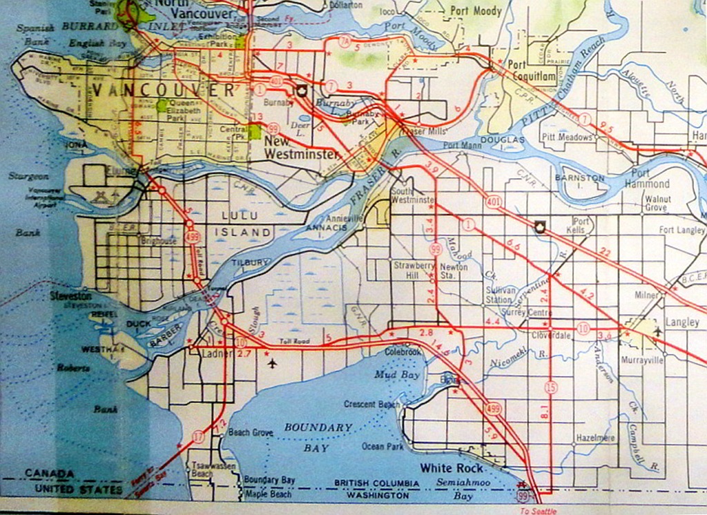
- Start-Class Canada-related articles
- Low-importance Canada-related articles
- Start-Class British Columbia articles
- Low-importance British Columbia articles
- Start-Class Vancouver articles
- Low-importance Vancouver articles
- All WikiProject Canada pages
- Start-Class Canada road transport articles
- Low-importance Canada road transport articles
- Start-Class British Columbia road transport articles
- Low-importance British Columbia road transport articles
- British Columbia road transport articles
- British Columbia road transport articles with KML
- Start-Class Road transport articles
- Low-importance Road transport articles
- Canada Roads project articles without needs-map