Oricum is part of the WikiProject Albania, an attempt to co-ordinate articles relating to Albania on Wikipedia. If you would like to participate, you can edit the article attached to this page, or visit the project page, where you can join the project and/or contribute to the discussion. If you are new to editing Wikipedia visit the welcome page so as to become familiar with the guidelines. If you would like to participate, please join the project and help with our open tasks.AlbaniaWikipedia:WikiProject AlbaniaTemplate:WikiProject AlbaniaAlbania articles
This article is within the scope of WikiProject Illyria, a collaborative effort to improve the coverage of Illyria and Illyrians on Wikipedia. If you would like to participate, please visit the project page, where you can join the discussion and see a list of open tasks.IllyriaWikipedia:WikiProject IllyriaTemplate:WikiProject IllyriaIllyria articles
This article is within the scope of WikiProject Classical Greece and Rome, a group of contributors interested in Wikipedia's articles on classics. If you would like to join the WikiProject or learn how to contribute, please see our project page. If you need assistance from a classicist, please see our talk page.Classical Greece and RomeWikipedia:WikiProject Classical Greece and RomeTemplate:WikiProject Classical Greece and RomeClassical Greece and Rome articles
This article is within the scope of WikiProject Greece, a collaborative effort to improve the coverage of Greece on Wikipedia. If you would like to participate, please visit the project page, where you can join the discussion and see a list of open tasks.GreeceWikipedia:WikiProject GreeceTemplate:WikiProject GreeceGreek articles
This article links to one or more target anchors that no longer exist.
[[Protected areas of Albania#Archaeological Parks|archaeological park]] The anchor (#Archaeological Parks) is no longer available because it was deleted by a user before.
Please help fix the broken anchors. You can remove this template after fixing the problems. | Reporting errors
If you keep unconstructive editing, I will add also several scholars that consider the subject of this article an Illyrian harbor or an Illyrian city, like the sources you use in Amantia. Since you don't accept an Illyrian descriprion of Amantia into the lead, then I could ask for the removal of Ancient Greek from Oricum as well. Both the cities are clearly described in ancient sources, Amantia as Illyrian and Oricum as Greek. As I told you several times, double standards are not allowed, make your choice. – Βατο (talk) 08:34, 12 September 2022 (UTC)[reply]
Based on the strength of the sources, the best thing is to describe Amantia as an Illyrian city and Oricum as a Greek city. Ktrimi991 (talk) 21:20, 12 September 2022 (UTC)[reply]
Oricum is attested firstly as a harbor, after two centuries as a Greek city. Reliable sources make clear the human history and evolution of the site of Oricum, which is accurately included into the current version of the article. Also the current version of Amantia is acceptable. – Βατο (talk) 21:32, 12 September 2022 (UTC)[reply]
It is very easy to find sources that describe it as a harbor in Epirus [1][2][3] , so "Illyrian harbor" is WP:CHERRY and WP:POV. Btw, in the Roman period it was in the Roman province of Epirus (specifically, Epirus Vetus), and not in Illyricum, which was well to the north. Khirurg (talk) 03:38, 13 September 2022 (UTC)[reply]
"Illyrian harbor" is about the earliest period, don't remove well sourced content. As for the Roman province, it is also Illyris/Illyricum, or Epirus Nova as well. The information about Epirus and Illyria is stated in a general way in the first sentence of the lead. As for the lede material, your edit summary is a very weak argument, not only content about Greeks is important, local Illyrian human history that initially did not interact with Greeks, is relevant as well, as per reliable sources. – Βατο (talk) 08:42, 13 September 2022 (UTC)[reply]
I included context according to the ancient and modern sources. Now it is more clear. – Βατο (talk) 11:33, 13 September 2022 (UTC)[reply]
Absolutely not. Many top notch academic sources place Oricum in Epirus in the early period, e.g. Hernandez [4]. The current lede is unacceptably POV and will be changed. As far as the Roman provinces, Epirus Vetus and Epirus Nova were in the province of Macedonia, and had nothing to do with Illyricum (Roman province) which began in northern Albania and Montenegro. The only "Illyricum" that Oricum was located was the Praetorian prefecture of Illyricum, which was created in the fourth century AD and included all the western Balkans, so it's trivial. Khirurg (talk) 14:53, 13 September 2022 (UTC)[reply]
Many scholars consider it an Illyrian city, are we going to include this too? Oricum became part of the Roman protectorate of Illyricum in 228 BC. The province of Illyricum is another thing. Also it was placed in Epirus Nova (Illyris proper) when Epirus Vetus became part of Achaea. – Βατο (talk) 14:55, 13 September 2022 (UTC)[reply]
"Illyrian harbor" pretty much implies the same thing. Far too many sources place it in Epirus for that to be acceptable. Let me remind you that many sources (e.g. Wilkes) place the boundary between Epirus and Illyria at the Aous. "Between Epirus and Illyria" is the most neutral and it will be restored. The current lede is terrible, it is so badly written it implies Oricum moved around from place to place. And it was in Epirus Vetus, not Epirus Nova. Khirurg (talk) 15:34, 13 September 2022 (UTC)[reply]
No, it was in Epirus Nova, when Epirus Vetus was included in Achaea, as per Shpuza; have you a source for your claim? The Greek colony was founded in Illyrian territory, it's why "Illyrian harbor" can't be removed from the lede. Otherwise I will add many top notch scholars that consider it an Illyrian city, and then also "Greek polis" will go. Remember that double standards are not allowed, make your choce. – Βατο (talk) 15:52, 13 September 2022 (UTC)[reply]
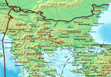
Don't issue threats and ultimatums. This is the second time you do so on this talkpage ("If you do not give in to my demands, I will make the article even more POV). If there is a third, you will be reported. As you will if "Greek polis" will go. You know full well this was Euboean Greek colony, and sources only refer to it as "Illyrian" because of the location. The inhabitants were Greek and spoke Greek, there is nothing "Illyrian" about it. And there is no such thing as Roman protectorate of Illyricum, there is only Illyricum (Roman province) and the Praetorian prefecture of Illyricum. This map clearly shows it was in Epirus Vetus, part of the province of Macedonia. Oricum was located in Epirus Vetus (barely, but still).Khirurg (talk) 16:07, 13 September 2022 (UTC)[reply]
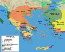
Those are not threats, I am searching for compromise, because you clearly keep using double standards, they have to be avoided. Here is a map about Roman protectorate in Illyricum (see also Ivetic 2022, p. 44 for the situation after 228 BC). Furthermore, Epirus Nova is also called Illyris, and it is completely different from Epirus Vetus (Shpuza says that Oricum was included in New Epirus when Old Epirus became part of Achaea). As for the Euboean foundation, it is almost rejected in current scholarship, because there is no pre-6th century BC evidence of settlement. As for the inhabitants, like Dyrrhachium and Apollonia, Greek colonists might well have been mixed with the local population. So, the term "Illyrian city" is not to be considered as explicitly referring to a geographical context by the scholars. Anyway, I think the current version is a neutral wording of the description and historical events of Oricum. Roman potectorate in Illyricum – Βατο (talk) 16:25, 13 September 2022 (UTC)[reply]
You're not searching for any compromise, you are just imposing your version by edit-warring and then making threats that if I do not give in to your edit-warring you will make the article even more POV. You have already done this twice: If you keep unconstructive editing, I will add also several scholarsOtherwise I will add many top notch scholars that consider it an Illyrian city. Hernandez 2010, one of the top sources on this topic, clearly considers Oricum a Greek colonial foundation: rather they were southern Greek colonial foundations. These poleis were generally situated along the coast, at locations such as Ambracia, Amphilochian Argos, Buchetium, Buthrotum, Oricum, and Thronium. As for Epirus Nova, yes Shpuza considers it in Epirus Nova, but nowhere does he mention that Epirus Nova was also called Illyris. He only says that Epirus Nova was part of Macedonia. You don't have a single source for Greek colonists might well have been mixed with the local population., nothing, just speculation and WP:OR. What "local Illyrians"? The site was uninhabited. The map of the protectorate you posted, shows a protectorate, but does not call it "Illyricum". You don't have a single source that establishes the existence of a Roman protectorate of Illyricum. Khirurg (talk) 16:42, 13 September 2022 (UTC)[reply]
The roman protectorate in Illyricum can be sourced with several scholars, and it is obvious, since Roman influence came on Illyrian coast after Teuta's defeat in the First Illyrian War. For instance I am reporting Ivetic 2022, p. 44: "As a consequence, in 229 there followed a rapid war, which the Romans won. Queen Teuta, Agron's widow, was forced to retreat to the Bay of Kotor. In 228, the Romans imposed a protectorate on the islands of Issa (Vis) and Corfu, and on the cities of Epidamnos (Durrës), Apollonia (present-day Pojani) and Oricum (Orikum) in the bay of Vlorë. This protectorate coincided with the use of the Roman concept of Illyricum." The city of Oricum is considered a Greek foundation (different from the particular Euboean tradition, which would date back much earlier than the 6th century BC), but that does not imply that the context preceding the Greek colony/polis should be removed from the first sentence. – Βατο (talk) 17:05, 13 September 2022 (UTC)[reply]
There is no such thing as a Roman protectorate of Illyricum. There was a Roman protectorate in the area, but that does not mean it was called "Illyricum", which is what "Roman protectorate of Illyricum" implies. The problem with the first sentence is that as you know countless scholars place the boundary between Illyria and Epirus further north (Wilkes, Hernandez, Hammond, to name but a few), so referring to it is solely as "Illyrian harbor" is POV. An acceptable compromise would be "Illyrian/Epirote" harbor or something like that. Referring it solely as "Illyrian harbor" in the first sentence of the lede is not any kind of compromise. Khirurg (talk) 17:22, 13 September 2022 (UTC)[reply]
And who said that it was officially called "Roman protectorate of Illyricum"? Reliable sources state that the Roman protectorate was established in Illyria/Illyris/Illyricum, and it is unquestionable, as it comprised Illyris proper. The "Illyrian/Epirote" wording is not accurate, because at the time of it's foundation, the hinterland was an Illyrian-inhabited area. Note that it is worded "Illyrian harbor", not linking the term "Illyrian". Also, as you know, the inclusion of "Epirote" could imply that the area of the hinterland of this site was already inhabited by Greeks before the foundation, which is not supported by the sources. – Βατο (talk) 17:52, 13 September 2022 (UTC)[reply]
As Wilkes makes clear(p. 208), the term "Illyricum" began to be used only after the mid-1st century BC By the middle of the first century the Romans were using the name Illyricum for their Adriatic territories north of the Drin, south of which the province Macedonia began., and even then it referred only to the area in northern Albania. To use it to describe a protectorate of the 3rd century BC is anachronistic. I see your point about "Illyrian/Epirote", but there needs to be some kind of amendment to "Illyrian harbor". The area was uninhabited prior to the 6th century BC, which is when the colony was founded since that is the tail end of the age of Greek colonization. Many authors also place it in Epirus no matter the time period, so "Illyrian harbor" is POV. It has to change, something like "a harbor between Illyria and Epirus". Khirurg (talk) 18:23, 13 September 2022 (UTC)[reply]
Wilkes does not make clear "Illyricum" began to be used only after the mid-1st century BC, that's your completely incorrect interpretation. Illyricum was the Latin term for Illyria, not just the term for the Province that was established in Imperial times. Also, Wilkes' includes Oricum in the "Illyrian Lands" map (Map 1). As stated by the sources, before the Greek colony it was an Illyrian port, and it should be explained in the first sentence. Before Dyrrhachium, it was the eastern principal harbor of the main sea route linking southern Illyrians with Iapygia. Mentioning "Illyrian harbor" is as relevant as mentioning that it was a Greek city in later times. – Βατο (talk) 19:01, 13 September 2022 (UTC)[reply]
It was an "Illyrian harbor" only due to geography, and only according to those sources that place it in Illyria (Aand just as many sources refer to it as a port in Epirus). The site was entirely uninhabited prior to the establishment of the colony. It is misleading to refer to it as an Illyrian harbor, since the Illyrians didn't build anything there. "Harbor in Illyria" would be better, but even that is POV because many sources place it in Epirus. Illyricum was the Latin term for Illyria, not just the term for the Province that was established in Imperial times. is unsourced and WP:OR. Khirurg (talk) 20:48, 13 September 2022 (UTC)[reply]
"Illyricum was the Latin term for Illyria, not just the term for the Province that was established in Imperial times. is unsourced and WP:OR." WP:Competence is required. Read the reliable sources, I am not arguing about that anymore.
Before the Greek settlement, the site was a natural port used since prehistoric times, and its hinterland was inhabited by Illyrians. Reliable sources make it clear, and it is relevant for the description of the site. Also, don't select content from Hernandez (2010) to make a specific POV narrative. Hernandez (2017) states: (257–258): "Drawing upon earlier written sources about sailing voyages (periploi), the Periplous of Pseudo-Skylax (28–33) traces the coast of the Mediterranean and purports to be a “circumnavigation of the inhabited world”. The text was composed in the third quarter of the 4th century B.C. The description of Epeiros moves southward along the Adriatic and Ionian Seas in the direction of mainland Greece. It appears to represent Epeiros in the years ca. 380–360 B.C. In Illyria, Epidamnos and Apollonia are listed as Greek cities (πόλεις Ἑλληνίδες). Orikos is identified as a polis located within the territory of an Illyrian city, Amantia. After Illyria, the text lists Chaonia." Especially after this edit, it clearly illustrates your usage of double standards. Btw, the Euboean founding myth and the reason of its construction will be restored, no reason to remove it. Despite the fact that so far it appears to be a non-historical tradition, it evidently played a certain role in the history and culture of the city. – Βατο (talk) 22:00, 13 September 2022 (UTC)[reply]
There is absolutely no reason to restore the Euboean foundation, since according to you it is "rejected". You changed your mind now? It is not lede material. If you add it, I will revert it. There are no double standards at all, I did not remove the part from Hernandez that locates Oricum in the territory of Amantia, it is still there. Herenandez does NOT say it was an Illyrian city, don't even think about misquoting him. And since it was a prehistoric harbor, that's what it should say instead of a non-existence Illyrian presence "in the hinterland". Khirurg (talk) 22:17, 13 September 2022 (UTC)[reply]
You had also falsified Shpuza, luckily I spotted it and fixed it. Don't waste your time doing it again, all your contribs will be checked. Khirurg (talk) 22:18, 13 September 2022 (UTC)[reply]
That info was left after several edits. Nevertheless, Epirus Nova is synonym with Illyris Proper, and it was a more balanced way to include the city not only in Epirus Nova, but also in Epirus Vetus. I suggest you to assume good faith, but feel free to check every edit you want. "since according to you it is "rejected" I did not say it, I said that "it is almost rejected in current scholarship". Despite that, my opinion is not relevant for it, it was made in another context. Scholars report and discuss the ancient tradition because it is relevant for the subject of the article, despite its dubious historicity, hence it can be included into the lede. – Βατο (talk) 22:47, 13 September 2022 (UTC)[reply]
The lede should provide a summary of the main points of the article that are informative to the reader, not copy paste one's "favorite" sentences. This is not one of them, since it is rejected by modern scholarship. Scholars report and discuss the ancient tradition because it is relevant for the subject of the article: Not really. For instance Hernandez doesn't mention is anywhere in his entire dissertation. Khirurg (talk) 03:33, 14 September 2022 (UTC)[reply]
We don't know which southern Greek colonists Hernandez (2010) is referring to, it could have referred to Euboeans, as it is a 2010 publication concerning excavations at Butrint (2004-2007), before the ending of the Albano-Swiss excavations at Orikos, which has been finally reported in 2013, making the tradition of Euboean foundation unlikely from an archaeological standpoint. The polis could also have been founded by Corcyra, which seems to have been related to Orikos in Classical times. Nevertheless the Euboean foundation is the most deeply rooted in the tradition of the city, Roller 2021, p. 82:"Orikos, or Orikon (at modern Orikumi) is little known beyond having been a Euboean foundation.". It is the most renowned ancient description concerning the polis of Orikos, its existence in ancient literature and the reason of its construction are worth a mention into the lede. – Βατο (talk) 08:23, 14 September 2022 (UTC)[reply]
Shpuza (2022): "Cette po-sition frontalière a probablement occasionné des malentendus parmi les auteurs anciens sur son po-sitionnement en Illyrie ou en Épire. Cependant, tous ceux qui connaissent la géographie imaginent mal que le territoire d' Épire puisse aller au-delà des Monts Cérauniens, qui représentent une frontière naturelle difficilement franchissable. D'après les données à notre disposition, Orikos n'a fait partie de l'Épire que pendant le Royaume de Pyrrhos au début du 3e siècle avant J.C." ["This border position probably caused misunderstandings among ancient authors about its position in Illyria or Epirus. However, anyone who knows geography finds it hard to imagine that the territory of Epirus can go beyond the Ceraunian Mountains, which represent a natural border that is difficult to cross. According to the data at our disposal, Orikos was only part of Epirus during the Kingdom of Pyrrhos at the beginning of the 3rd century BC.6"].
The site was naturally into contact with the Illyrian north, the Epirote south was naturally inaccessible from the site of Orikos, due to the mountains. So, the current wording of the first sentence stays. – Βατο (talk) 10:02, 14 September 2022 (UTC)[reply]
Also, the wording that Philip V's conflict against Rome was in "Epirus and Illyria" is historically inaccurate and will be reverted. Philip aimed to control the Illyrian Adiatic in order to contrast Roman influence in Illyria and to have access to the main Illyrian coastal settlements, Epirus is unrelated with those events. – Βατο (talk) 10:14, 14 September 2022 (UTC)[reply]
Since Oricum was considered to be in Epirus and Illyria at the time of Philip V, the wording "in Epirus and Illyria" is correct. Regarding the tradition of foundation by Euboeans, "it is the most renowned ancient description" is just your opinion. If it was so renowned, why do archeological sources like Hernandez not even mention it. I do agree with you that a Corcyrean foundation is the most likely, but either way, there is no question that it was a Greek colonial foundation. Khirurg (talk) 22:40, 14 September 2022 (UTC)[reply]
No, that wording is historically inaccurate. Reliable sources make clear that Philip V tried to control the main Illyrian coastal cities that have been under Roman influence since the First Illyrian War. Those cities were important because they would have allowed Philip a direct access form the Illyrian hinterland to the Illyrian coast, through which he would have been able to cross the Adriatic and reach Italy. Epirus is unrelated to those events. – Βατο (talk) 10:38, 15 September 2022 (UTC)[reply]
It messes up pre-Roman and Roman era geography and history from the 1st sentence. The prose is severely tortured from 1st line and needs to be split in two (1st sentence: pre-Roman polis and location, 2nd line: Roman-era city and location in terms of contemporary adminstration) . Also the statement about the so-called Illyrian harbor is completely fictional; no record mentions a 7th-6th century Oricum as an Illyrian harbor. Hecateus states:
Skylax also rejects this 'Illyrian harbor' hypothesis and locates Oricum at the border of Epirus and Illyria. Maximizing Illyria is POV Alexikoua (talk) 21:14, 12 December 2022 (UTC)[reply]
The polis is firstly mentioned as located in Illyria. The polis emerged from a previous harbor on the coast of a plain/valley that stretched north of the Keraunian Mts. and that was inhabited by the southernmost Illyrians. The current lede is already accurate, your edits are not improvements. – Βατο (talk) 22:50, 12 December 2022 (UTC)[reply]
"The polis is firstly mentioned as located in Illyria" is OR, Stocker states about Skylax that Oricum is on the border of Epirus and Illyria. Quote from Stocker: Pseudo-Scylax (28) notes that Oricum, just south of the Aous, marked the end of Illyrian territory and the beginning of Chaonia (Epirus). So why you keep removing this sourced information as OR? Antother discrepancy is the supposed foundation on the Illyrian coast, however Hecateus states that it was an Epirote harbor not an Illyrian one:
Pseudo-Skylax does not locate the polis in Chaonia, but in the territory if Illyrian Amantia. Your wording repeats information that is already clarified into the lede. About Hecataeus and other ancient authors, read Shpuza (2022). The harbor is placed in the plain/valley of Dukat, north of the Keraunian Mts., an area inhabited by the southernmost Illyrians in classical times, and at least since the late Bronze Age, as the tumuli suggest. Chaonians, the northernmost Epirotes, inhabited the area south of the Keraunians. – Βατο (talk) 23:12, 12 December 2022 (UTC)[reply]
"About Hecataeus and other ancient authors, read Shpuza"? I've provided the exact quote which states that Oricum was a harbor in Epirus. It is up to you to provide precise arguments about Shpuza or however turn Hecateus quote useless / wrong. Pliakou also states that the northernmost border of Epirus is located in Oricum (and she cites - no wonder Hecateus). Pliakou, Hatzopoulos (2020), Stocker are serious historians that are based on various ancient authors (and not only), they all point that Oricum was in Epirus. Filios also mentions Oricum as part of the northern Epirus cities which the local Greek dialect was spoken.Alexikoua (talk) 02:46, 13 December 2022 (UTC)[reply]
This suffices, Shpuza (2022): "Cette po-sition frontalière a probablement occasionné des malentendus parmi les auteurs anciens sur son po-sitionnement en Illyrie ou en Épire. Cependant, tous ceux qui connaissent la géographie imaginent mal que le territoire d' Épire puisse aller au-delà des Monts Cérauniens, qui représentent une frontière naturelle difficilement franchissable. D'après les données à notre disposition, Orikos n'a fait partie de l'Épire que pendant le Royaume de Pyrrhos au début du 3e siècle avant J.C." ["This border position probably caused misunderstandings among ancient authors about its position in Illyria or Epirus. However, anyone who knows geography finds it hard to imagine that the territory of Epirus can go beyond the Ceraunian Mountains, which represent a natural border that is difficult to cross. According to the data at our disposal, Orikos was only part of Epirus during the Kingdom of Pyrrhos at the beginning of the 3rd century BC.6"]. As for authors that mention it in Epirus, it could well be Epirus Nova, nevertheless, the Illyrian coast is clearly interrupted by the Acroceraunian promontory. We have already discussed this several times also in other articles, and the current lede of this article explains it extensively and accurately. – Βατο (talk) 10:39, 13 December 2022 (UTC)[reply]
I still wonder what makes you remove Hecataeus statement from the article (Hecateus is 6th century BC, there was no Epirus Vetus/Nova that time). Shpuza does not refer to this statement but offers a generic view on later era georgaphy (Hellenistic/Roman era). No wonder we see nothing about Hecateus description which you keep removing although it is widely backed by a mountain of top graded specialists (Pliakou, Hernandez, Stocker, Handeli). Hatzopoulos (2020) whom you are quite familiar is also clear about Oricum being located in Epirus. As such at the time the colony was founded it wasn't Illyrian (no wonder Shpuza doesn't say a word about a so-called Illyrian harbor there that time).
Also we need to avoid mixing up pre-Roman and Roma era information inside the 1st sentence and then again providing information of a previous era and then again going fast forward to Roman era administration. That's bad prose. Look for example in Amantia and Byllis; although they were Roman cities (Byllis even colonized by Romans) this is not mentioned at the very begininning.Alexikoua (talk) 23:27, 13 December 2022 (UTC)[reply]
Shpuza (2022)'s analysis takes into account all the relevant ancient litterature (including Hecataeus) and the actual geographical features of the area. Orikos is placed on the north of the Dukat plain/valley, to the north of the Ceraunian Mts. And it has been already clarified several times that those mountains mark the separation of the Illyrian coast form the Epirote coast, with Orikos naturally placed on the Illyrian side. Also, your additons about Hecataeus have not been removed, I moved them into the relevant section. And don't repeat the "top graded specialists" argument, as several cities traditionally located in Epirus are placed in Illyria by "top graded specialists" as well, but no one is suggesting to include that info in those articles. We should rely on the mostly accepted descriptions in scholarship, giving more prominence to those that specifically focus on the subject of the relevant articles, and in this respect, Shpuza (2022) provides the most in-depth analysis. – Βατο (talk) 01:05, 14 December 2022 (UTC)[reply]
It's very weird since here [[5]] you declared that the Illyrian lands were limited to the hinterlands of the gulf of Valona, and as such you were stating that Oricum outside of the Illyrian area:
:::"Illyrii, a large group of related *Indo-European tribes, who occupied in classical times the western Side of the Balkan range from the head of the *Adriatic Sea to the hinterland of the gulf of Valona and extended northwards as far as the eastern *Alps and the Danube (see DANUVIUS) and eastwards into some districts beyond the Balkan range. The name was properly that of a small people between Scodra and the Mati river, and it was applied by the Greeks and later by the Romans to the other tribes with which they had regular contact. Thus Illyris meant to the Greeks the southern part of the area, that neighbouring *Mace-donia, *Epirus, and the Greek cities on the Adriatic coast and islands, and *Illyricum meant to the Romans the whole area from the eastern Alps to the gulf of Valona.". So, there is no need to continue this discussion any longer. – @Your comment in talk:Amantia
You gave an answer. It's not productive to change positions simply depending on a certain POV. By the way there is no guideline to turn a mountain of top graded authors completly useless and remove them altogether bacause there is one its fits your positions. We have a lot of authors on the issue: Hatzopoulos, Pliakou, Hernandes, Stocker etc. and their opinions need to be presented in the text. Alexikoua (talk) 02:45, 14 December 2022 (UTC)[reply]
Actually, that definition goes against your opinions. Hammond&Wilkes 2012 "Illyrii, a large group of related *Indo-European tribes, who occupied in classical times the western Side of the Balkan range from the head of the *Adriatic Sea to the hinterland of the gulf of Valona [...] Thus Illyris meant to the Greeks the southern part of the area, that neighbouring *Mace-donia, *Epirus, and the Greek cities on the Adriatic coast and islands, and *Illyricum meant to the Romans the whole area from the eastern Alps to the gulf of Valona." Orikum is located in the southern end of the Gulf of Valona, on the north of the Dukat plain/valley. Dukat (south of Orikum) can't be considered part of Epirus proper, which began south of Keraunian Mts. And Shpuza (2022): anyone who knows geography finds it hard to imagine that the territory of Epirus can go beyond the Ceraunian Mountains, which represent a natural border that is difficult to cross. According to the data at our disposal, Orikos was only part of Epirus during the Kingdom of Pyrrhos at the beginning of the 3rd century BC. rejects your demands. Already said several times: some scholars who locate Orikum in Epirus (mainly in passing) mean nothing, it could well be Epirus Nova. Sources that specifically focus on the suject of this article should have priority. – Βατο (talk) 10:24, 14 December 2022 (UTC)[reply]
Btw, the current version of the lede is the result of consensus among several editors (including you): [6]; [7]; [8]; [9]. We agreed to change the previous wording, despite the fact that it was supported by several sources in the first citation. I am not continuing this discussion that was already solved with fellow editors. Open a RfC if you want to change the lede again. – Βατο (talk) 10:35, 14 December 2022 (UTC)[reply]
Ths version about the supposed 'Illyrian harbor' was indroduced by you and no wonder it's OR too. There wasn't an Illyrian coast there at 6th cent. BC so it's time to get rid of this POV. By the way you keep pushing maximalist dreams: when a source states that Illyria stretched region X this can mean that region X is the border zone between Illyria and a neighboring region Also Hatzopoulos, Herndandes, Stocker, Pliakou, Hammond need also to be mentioned in this as they state that the Ilyrian - Epirote border zone was at the gulf of Valona (i.e. both Epirotes and Illyrians were this as this was a border region) and the mouth of Aoos. Stocker is clear that only some Albanian authors have a diferrent position but that's a minority view.
All views should be mentioned in article as Stocker describes them in detail. Alexikoua (talk) 23:13, 14 December 2022 (UTC)[reply]
By the way there is a disagreement in scholarship for Amantia / Amantes if they were Epirotes or Illyrians. This should be also reflected here.Alexikoua (talk) 23:20, 14 December 2022 (UTC)[reply]
The current version was agreed a few months ago by several editors including you. Open a RfC if you want to change it again. As for "Illyrian port/harbor", it is not OR, there are several sources already into the article that support it. – Βατο (talk) 23:27, 14 December 2022 (UTC)[reply]
I fail to see that. In fact all views are good to be part in the text, that's called productive editting. In case you mislike Hammond, Hernandez, Stocker, Hatzopoulos, Pliakou, Hadeli fill an RSN.Alexikoua (talk) 03:46, 15 December 2022 (UTC)[reply]
By the way the concept that Acroceraunia was inaccesible for the Epirotes appears childish in the rest of the bibliography: Epirus is 90% of mountain terrain, while even Acroceraunia was full of trails from Shushicë and Kuc. Shushicë was called Chaonites in antiquity by the way. Dausse about the so-called inaccesibility of Acroceraunia:
Elle s’applique en revanche moins bien au fleuve Aoos48 pour définir une frontière entre Épire et Illyrie. Pour les zones de montagnes, nous pouvons citer les monts Acrocérauniens49 qui pourraient marquer le passage entre la partie chaone de l’Épire et l’Illyrie. Mais la plupart du temps, la montagne est le lieu de vie de nombreuses populations de la Grèce du Nord. À ce titre, elle constitue plus un lieu de rencontre50 qu’une barrière51.Alexikoua (talk) 04:07, 15 December 2022 (UTC)[reply]
See the topography of the area in the [map] and the mainstream views about the description of those regions:
Hammond & Wilkes (2012): "Illyrii, a large group of related *Indo-European tribes, who occupied in classical times the western Side of the Balkan range from the head of the *Adriatic Sea to the hinterland of the gulf of Valona [...] Thus Illyris meant to the Greeks the southern part of the area, that neighbouring *Mace-donia, *Epirus, and the Greek cities on the Adriatic coast and islands, and *Illyricum meant to the Romans the whole area from the eastern Alps to the gulf of Valona.";
Filos (2017): "one may say with some degree of certainty that from the 4th c. BC onwards the geographic boundaries of Epirus were by and large set as follows: the so called Keraunia or Akrokeraunia mountain range to the north (modern day S. Albania), ..."
The more in-depth geographical analysis of the specific local area:
Shpuza (2022): "Cependant, tous ceux qui connaissent la géographie imaginent mal que le territoire d' Épire puisse aller au-delà des Monts Cérauniens, qui représentent une frontière naturelle difficilement franchissable. D'après les données à notre disposition, Orikos n'a fait partie de l'Épire que pendant le Royaume de Pyrrhos au début du 3e siècle avant J.C." ["anyone who knows geography finds it hard to imagine that the territory of Epirus can go beyond the Ceraunian Mountains, which represent a natural border that is difficult to cross. According to the data at our disposal, Orikos was only part of Epirus during the Kingdom of Pyrrhos at the beginning of the 3rd century BC.]"
Further analysis of the topography of the area and the difficulties to cross the Keraunian Mts.:
Volpe et al. (2014): "Le difficoltà di collegamento tra la Baia di Valona e la costa albanese meridionale, a sud del promontorio di Karaburun, sono evidenziate nel De bello civili da Cesare, quando, nell’inverno del 48 a.C., ormeggiate le navi a Paleste, a nord di porto Palermo, è costretto, con grandi difficoltà, ad attraversare il Passo di Llogara alla volta di Oricum, allora nella mani di Pompeo" ["The difficulties of connection between the Bay of Vlora and the southern Albanian coast, south of the promontory of Karaburun, are highlighted in the De bello civil by Cesare, when, in the winter of 48 BC, the ships moored in Paleste, north of the port Palermo, is forced, with great difficulty, to cross the Llogara Pass towards Oricum, then in the hands of Pompey".
Oricum is located on the north of the the Dukat plain, in the north of the Keraunian Mts (note: not in the south) and constitutes the south-eastern hinterland of the Bay of Vlore inhabited by the southernmost Illyrians according to mainstream views. Also according to mainstream views Oricum was a Greek colony on the Adriatic sea. And the eastern Adriatic coast coincides with the Illyrian cost, unlike the Ionian coast which coincides with the Epirote coast. – Βατο (talk) 21:52, 17 December 2022 (UTC)[reply]
Hatzopoulos' conclusion should be restored back to the text. His conclusion isn't OR as you claim. As for Spuza he actually accepts that multiple sources present it as an Epirote settlements (especially pre-Hellenistic), although his personal conclusion that Oricum is geographically on the Illyrian side of the Epirote-Illyrian border is solely based on the so-called inaccesibility of the Acroceraunians. Dause has a diferrent opinion on this. Thanks to my recent intervention Spuza is presented in a neutral way.Alexikoua (talk) 02:19, 18 December 2022 (UTC)[reply]
Although months of discussions have passed this wp:FRIDGE 'Oricum was simply a harbor' of unindentified charachter still pesist. This is not a case of concensus afterr after. Oricum was most of theancient times a polis and this should be clarifiy on intro.Alexikoua (talk) 18:51, 28 April 2023 (UTC)[reply]
Against the inaccessible passing of the Acroceraunian[edit]
Dausse (2015):De celle-ci dépend la frontière entre Illyriens et Épirotes. Elle s'applique en revanche moins bien au fleuve Aoos pour définir une frontière entre Épire et Illyrie. Pour les zones de montagnes, nous pouvons citer les monts Acrocérauniens qui pourraient marquer le passage entre la partie chaone de l'Épire et l'Illyrie. Mais la plupart du temps, la montagne est le lieu de vie de nombreuses populations de la Grèce du Nord. À ce titre, elle constitue plus un lieu de rencontre qu'une barrière.Alexikoua (talk) 02:31, 18 December 2022 (UTC)[reply]
Malkin (1998): As Beaumont observes, it had easy access to the small harbour Panormus across the peninsula over the Logara Pass, thus providing it with good communications with Corcyra and the Euboean position on the mainland opposite Corcyra.
Border of Epirus-Illyria in the ancient world[edit]
Hernandez (2010): Epirus is situated in the western Balkans and is today divided between southern Albania and northwest Greece (Fig. 3). Its coastline faces the Ionian Sea, from the Gulf of Aulon (located opposite Italy at the Strait of Otranto) to the Gulf of Arta, that is, from the ancient territories of Oricum and Amantia in the north to the ancient territories of Ambracia and Amphilochian Argos in the south, respectively.
Wilkes (1992):Appian's description of the Illyrian territories records a southern boundary with Chaonia and Thesprotia, where ancient Epirus began south of the river Aous (Vijose).Alexikoua (talk) 02:31, 18 December 2022 (UTC)[reply]
It's not an "easy access", those quotes highlight their limited knowledge of the local topography. Shpuza (2022): ["anyone who knows geography finds it hard to imagine that the territory of Epirus can go beyond the Ceraunian Mountains, which represent a natural border that is difficult to cross."]; Volpe et al. (2014): ["The difficulties of connection between the Bay of Vlora and the southern Albanian coast, south of the promontory of Karaburun, are highlighted in the De bello civil by Cesare, when, in the winter of 48 BC, the ships moored in Paleste, north of the port Palermo, is forced, with great difficulty, to cross the Llogara Pass towards Oricum, then in the hands of Pompey"].
The Gulf of Aulon is not on the Ionian Sea, but on the Adriatic Sea. Generally accepted definition: Illyrian coast = Adriatic coast, Epirote coast = Ionian coast. Wilkes (1992) reports a presumable description by Appian, not his own, for his own definition of Illyrian Lands, see Map 1 which delimits it with the Keraunian Mts. in the Llogara Pass like most other sources. And see Wilke's definition provided along with Hammond in the 2012 publication reported above. And Filos (2017): "one may say with some degree of certainty that from the 4th c. BC onwards the geographic boundaries of Epirus were by and large set as follows: the so-called Keraunia or Akrokeraunia mountain range to the north (modern-day S. Albania), the Ambracian Gulf to the South, the Pindus (Pindos) mountain range to the east, and the Ionian Sea to the west" makes other statements selected by some sources that go against mainstream scholarship less relevant. Anyway, this discussion is about the first sentence of the lede, decided months ago by consensus with several editors including you. To change it a RfC is needed. No need to continue this discussion here. Cheers. – Βατο (talk) 11:08, 18 December 2022 (UTC)[reply]
The statement: "anyone who knows geography finds it hard to imagine that the territory of Epirus can go beyond the Ceraunian Mountains" is a personal statement and since we have tons of ancient and modern authors that locate this city either on the Epirus/Illyria border or in Epirus all views are respected and should be part of the text. To remove Hatzopoulos, Malkin, Pliakou, Harnandez, Stocker on the geography issue of Oricum wp:RSN is needed.Alexikoua (talk) 03:16, 19 December 2022 (UTC)[reply]
The paragraph about 5th century BC inscriptions is in part original research not supported by the reference provided. It should be reworded appropriately according to the sources. – Βατο (talk) 11:47, 14 December 2022 (UTC)[reply]
If the content is not reworded properly according to the source, it will be removed. No 5th century BC inscriptions are found in Oricum. – Βατο (talk) 23:38, 17 December 2022 (UTC)[reply]
@Βατο: The quote is in page 225 and it talks about an oracular tablet from Dodona. There's nothing there which supports the section, so I removed it.Alltan (talk) 02:14, 18 December 2022 (UTC)[reply]
The oracular tablet concerns a question from Oricum. But you removed the entire paragraph (it's not a section) altogether without explaining the reason although Oricum is mentioned among the northern Epirote cities that used this dialect.Alexikoua (talk) 02:36, 18 December 2022 (UTC)[reply]
The first inscriptions in Oricum are from the Hellenistic period, not the 5th century BC. Provide accurate information according to the source, please. – Βατο (talk) 12:05, 18 December 2022 (UTC)[reply]
It's supposed to be supported in Shpuza 2002, p. 553, but no such information exist there. Nevertheless Shpuza, Cipa (2021), locate the eastern borders of the territory of Oricum at Lungarë. This makes Dukat a part of the polis' territory.Alexikoua (talk) 06:30, 18 December 2022 (UTC)[reply]
Read the whole page of the source (Shpuza 2022 p. 553). Dukat plain exactly constitutes the foot of these Mountains. Orikos the colonial city was located on the coast (originally on an Island), its hinterland was inhabited by indigenous Illyrians (see tumuli at Dukat). This is already mentioned into the article based on several sources. As for the territory under the influence of Orikos, its irrelevant here, the hinterlands of Greek colonies on the Adriatic were always inhabited by Illyrian peoples (see Epidamnos and Apollonia). – Βατο (talk) 10:34, 18 December 2022 (UTC)[reply]
Anyway, I removed one part as it is already mentioned in the section. – Βατο (talk) 12:32, 18 December 2022 (UTC)[reply]
The territory of Oricum reaches the summits of Çika and Lungarë (Shpuza, Cipa 2021). The work defines this as a "political territory" not a sphere of influence. Çika is found East-Southeast of Dukat plain, is that correct? The tumulus was abandoned at c. 700BC if you mean that. Alexikoua (talk) 05:42, 22 December 2022 (UTC)[reply]
No, Maja e Çikës is the highest peak of the Ceraunian Mountains, marking the southern border of the territory of Orikos. As for the political territory, read the whole passage from the source, Shpuza & Çipa (2021): "Politiquement, le territoire d’Orikos se situait à la frontière entre l’Épire et l’Illyrie (fig. 3 ), le col de Llogara étant le seul point de passage terrestre entre ces deux régions." [Politically, the territory of Orikos was located on the border between Epirus and Illyria (fig. 3 ), the pass of Llogara being the only land crossing point between these two regions.], note that Oricum was located in the north of the Llogara Pass. It is further clarified in Shpuza (2022): "Cependant, tous ceux qui connaissent la géographie imaginent mal que le territoire d' Épire puisse aller au-delà des Monts Cérauniens, qui représentent une frontière naturelle difficilement franchissable. D'après les données à notre disposition, Orikos n'a fait partie de l'Épire que pendant le Royaume de Pyrrhos au début du 3e siècle avant J.C." ["anyone who knows geography finds it hard to imagine that the territory of Epirus can go beyond the Ceraunian Mountains, which represent a natural border that is difficult to cross. According to the data at our disposal, Orikos was only part of Epirus during the Kingdom of Pyrrhos at the beginning of the 3rd century BC.]" Oricum was a port of the Adriatic Sea, and this sea coast was inhabited by Illyrians. The tumuli in the hinterland similar to the tumuli in Apulia provide evidence of communication between Illyrians on the eastern Adriatic and Iapygians on the western Adriatic, and it should be obvious because Oricum-Brindisi is the simplest route to cross the Adriatic. The movement of Indo-European peoples from western Balkans to south-eastern Italy is what mainstream scholarship discusses today while studying the Messapic language. As for the presence of Illyrians in the hinterland of Oricum (coinciding with Dukat plain) before the arrival of Greek colonists: the finds from the hinterland of Oricum offer no proof of any contacts of the Greeks with the local Illyrian population ." Also, Pseudo-Skylax's detailed description of the area clearly attests that it was inhabited by Illyrians. I don't understand what do you want to achieve in this discussion. – Βατο (talk) 10:25, 22 December 2022 (UTC)[reply]
Shpuza (2022) reports: "On ne connaît que peu de choses des origines de son urbani- sation. On ne sait pas non plus si elle fut à l'origine une colonie eubéenne. Le plus ancien témoignage de l'urbanisation de la ville est le mur d'enceinte, construit au IV siècle avant notre ère." ["Little is known about the origins of its urbanization. It is also not known whether it was originally a Euboean colony. The oldest evidence of the city's urbanization is the surrounding wall, built in the 4th century BC."] The statement "The polis was founded as a southern Greek colony rather than an indigenous foundation." included into the article and based on Hernandez' thesis (2010) is not clear. He does not explain what he means by "southern Greek colony". Although being considered by most scholars as a Greek city, its exact origins are still uncertain as it could have started to develop its urbanisation under the influence of poleis like Korkyra and Apollonia. – Βατο (talk) 23:32, 18 December 2022 (UTC)[reply]
Hernandez (2010) reads: To clarify, ancient Epirus did possess poleis, but these were not generally indigenous foundations; rather they were southern Greek colonial foundations. These poleis were generally situated along the coast, at locations such as Ambracia, Amphilochian Argos,Buchetium, Buthrotum, Oricum, and Thronium.. What exactly makes this statement not clear? Obviously "southern Greek colony" means either Corinthian or Euboean or a colony established by any other Greek metropolis that's located south of Epirus. Shpuza is also uncertain about the founders of Oricum. Urbanization is yet another issue. Nevertheless there are no Illyrian traces in terms of archaeology. Alexikoua (talk) 02:25, 19 December 2022 (UTC)[reply]
I have the feeling that the part below fits better to history section instead Mythology:
As a Euboean foundation it would date back to about the mid 8th century BC,[1][2] probably established as an Eretrianemporium,[3] or as a harbor by Eretrian refugees from Kerkyra after this island was conquered by the Corinthians, although the latter hypothesis is less likely.[4]
I see no traces of mythology so there will be no issue to make the move to history.Alexikoua (talk) 03:34, 19 December 2022 (UTC)[reply]
References
^Antonaccio, Carla M.; Cohen, Beth; Gruen, Erich S.; Hall, Jonathan M. (2001). Ancient Perceptions of Greek Ethnicity. Center for Hellenic Studies, Trustees for Harvard University. p. 189. ISBN978-0-674-00662-1. The maritime routes toward the Strait of Otranto were frequented by Greeks as early as ca. 800 B.C., and the Euboeans settled in Corcyra and Oricum in the Bay of Valona (facing Otranto) about the mid - eighth century .
^Malkin, Irad (2015). "Ithaka, Odysseus and the Euboeans in the eighth century". Euboica : L'Eubea e la presenza euboica in Calcidica e in Occidente. Publications du Centre Jean Bérard. Retrieved 18 December 2022. To sum up: a colonising Euboean presence at both Corcyra and Orikos may seem acceptable at least for the mid-eighth century, replaced at Corcyra by Corinth probably ca 733 (or possibly some twenty-five years later). The archaeological evidence from Otranto seems to suggest that this Greek presence was preceded by proto-colonial traffic and was directed not only with a view to commerce in the Epirote lands and the Ionian sea, sailing up the coasts, but also across the Otranto Straits, to Italy and possibly also to the Adriatic (the sea north of the Straits). The evidence points to contacts already ca 800 and the first half of the eighth century and may be thus termed proto-colonial
^Keith G. Walker, Archaic Eretria: A Political and Social History from the Earliest Times to 490 BC (Routledge, 2004: ISBN0-415-28552-6), p. 151.
^Malkin 1998, p. 80. sfn error: no target: CITEREFMalkin1998 (help)
Hernandez' statement remains ambiguous. I expanded the content about the origins/foundation also moving one part from mythology to history. As for "there are no Illyrian traces in terms of archaeology" it is incorrect, there are Illyrian archaeological artifacts as well. But I do not pretend to consider it an "Illyrian city", because although some scholars do, mainstream views consider it a "Greek city". – Βατο (talk) 11:50, 19 December 2022 (UTC)[reply]
That's the question: Hernandez statement and detail he offers in the subject is of great value without leaving any traces of doubt for the readers. What's really ambiguous is Shpuza (2021) vs Shpuza (2022) disagreement over the Illyrian/Epirote border. Declarations like "we all know that this isn't geographical in Epirus" are just personal comments and most important they don't fit with the mainstream scholarship.Alexikoua (talk) 16:24, 20 December 2022 (UTC)[reply]
The description "southern Greek colony" is too general, not to mention that there is no evidence in the site for any conclusion. – Βατο (talk) 20:17, 20 December 2022 (UTC)[reply]
I expanded the city's development according to bibliography and made some rewordings. If you want to include the Euboean foundation hypothesis into the lede, it could be done with WP:due weight, however its inclusion has been opposed in the past and a consensus about it should be reached. – Βατο (talk) 12:18, 22 December 2022 (UTC)[reply]
Malkin (2015) states: "As Beaumont observes, it had easy access to the small harbour Panormus across the peninsula over the Logara Pass, thus providing it with good communications with Corcyra and the Euboean position on the mainland opposite Corcyra." Boumont's publication dates back to 1936, it is an outdated source.
As for Malkin's opinions, Stocker (2009): "Malkin suggests that Oricum was founded in the 8th century B.C., contemporary with the Euboean settlements on Pithekoussai and Corcyra, as a way station on voyages across the Adriatic to Otranto;817 there is currently, however, no archaeological evidence for an early settlement there.818 [...] Malkin 1998a, p. 5, 2001b, p. 189. He suggests (2001b, p. 192), however, that Oricum was then on Sazan island in the Bay of Vlora with a peraia on the shore of the mainland opposite. There is no evidence to support this hypothesis, which is refuted both by the geography of the bay itself and by excavations on the mainland at the site believed by most to be that of Oricum. Malkin has no knowledge about the geography of the area (he cites an observation made by Boumont in 1936).
That source cannot have the same weight as the publications that exclusively focus on this subject, Shpuza (2022): "anyone who knows geography finds it hard to imagine that the territory of Epirus can go beyond the Ceraunian Mountains, which represent a natural border that is difficult to cross." and Volpe et al. (2014): ["The difficulties of connection between the Bay of Vlora and the southern Albanian coast, south of the promontory of Karaburun, are highlighted in the De bello civil by Cesare, when, in the winter of 48 BC, the ships moored in Paleste, north of the port Palermo, is forced, with great difficulty, to cross the Llogara Pass towards Oricum, then in the hands of Pompey"]
Considering that Oricum has an easy access to Panormus on the Ionain coast through the Llogara pass, situated at over 1000 meters of altitude, highlights a lack of proper knowledge about the actual topographical features of the area. Even Caesar (48 BC) provided evidence about it. – Βατο (talk) 16:19, 19 December 2022 (UTC)[reply]
Also, see Ceka (2011)] who analysed all the possible routes that might have been used in antiquity to cross the Ceraunian Mountains from the Ionian coast to the Dukat plain. – Βατο (talk) 17:32, 19 December 2022 (UTC)[reply]
I agree. The claim that the Llogara pass is an easy route is patent nonsense. Ktrimi991 (talk) 19:51, 19 December 2022 (UTC)[reply]
I would be more careful when judging Malkin's work as an excuse to promote a personal POV. I also fail to see what changed in terms of geographic observations since the 1930s not to mention that Dausse has also doubts about this boundary.Alexikoua (talk) 16:26, 21 December 2022 (UTC)[reply]
Ceka (2011) 's detailed information providing also photographies of the area leaves no doubts about the inaccuracy of Beaumont's (1936) "easy access" observation. – Βατο (talk) 18:34, 21 December 2022 (UTC)[reply]


.jpg)