
Talk:Toronto Belt Line Railway
| This article is rated Start-class on Wikipedia's content assessment scale. It is of interest to the following WikiProjects: | |||||||||||||||||||||||||||
| |||||||||||||||||||||||||||


illustrations[edit]
Some photos taken in 2003. Unfortunately they do not have a Wikipedia-compatible licence. --Mathew5000 05:50, 28 March 2007 (UTC)
Here's another photo. --Mathew5000 05:57, 28 March 2007 (UTC)
And one more. --Mathew5000 06:01, 28 March 2007 (UTC)
I have the good fortune of riding the Beltline 3 times a week, always with my camera, so I'd be more than happy to provide some photos... maybe the bridge over Yonge Street ( around http://wholemap.com/map/index.php?pin=SART-844 ), and a shot of the green Moore park Ravine similar to the old photo of the station that was once there... ( although I'm fond of the ever-changing graffiti under Eglinton Ave - http://wholemap.com/map/index.php?pin=SART-307 ) Basho 03:29, 7 June 2007 (UTC)
When were tracks removed from the Forest Hill portion?[edit]
I remember that in the 1970s if you walked along the Belt Line from Avenue Road to Old Park Road you could see the vestiges of railway tracks at various points. Not the actual metal tracks, but the wooden cross ties. Some photos from the lostrivers.ca site show the metal tracks intact in 1968 [1] [2] but not in 1975 [3]. But when was the last time trains ran on that segment (between Avenue Rd and Old Park Rd)? The article doesn't mention that. Surely there must have been trains on that stretch sometime in the 20th century, if the tracks were still there in 1968. Then, based on the 1975 photo and on my own memory, somebody must have ripped up the metal tracks sometime in the early 1970s; why was that done? And when, precisely? --Mathew5000 08:42, 28 March 2007 (UTC)
![[1]](http://lostrivers.ca/points/BeltlineJuly1968.jpg)
![[2]](http://lostrivers.ca/points/BeltlineAug1968.jpg)
![[3]](http://lostrivers.ca/points/BeltlineOc1975.jpg)
- The tracks were pulled up after the ditch for the Spadina Expressway was excavated in the early 1970s. Since the line was severed there was no need for the tracks after this. I have no information on when the last train ran. Atrian 11:37, 28 March 2007 (UTC)
- Service was running on the remaining stub to the west of the Allen into the early 1990s. My friend lived in an apartment building just east (like 50 yards) of the end of the rails, west of Marlee on Hopewell, and you'd periodically see boxcars further west. I believe they serviced a carpet plant. The rails at his end of the spur were not used at that point and were quite rusty, which is not surprising given all of the light industrial was closer to Caledonia (and now, gone). Maury Markowitz (talk) 12:50, 9 October 2008 (UTC)
Conflicts between sources[edit]
| This section is pinned and will not be automatically archived. |
Fare[edit]
TRHA Historian Derek Boles describes the fare as "the Belt Line's 25-cent fare". The Lost Rivers site says "the fare between any two stops on the line was set at twenty-five cents", and other sources repeat this statement all apparently referring to the same source. A local fare of over $1 for a local trip seems implausible for the 1890s. Joan C. Kinsella says "a fare of five cents was charged at each stop." So, I assumed that Boles meant 25 cents per trip, thus, 25 cents per trip or 5 cents between any two stations.TheTrolleyPole (talk) 23:53, 1 March 2017 (UTC)
- R.L.Kennedy's Toronto Belt Line article resolved the dilemma saying: "Fares were said to be 5 cents per station which added up if you travelled a long distance. Even the maximum fare of 25 cents was a significant amount. Newspapers were 1 cent at the time." TheTrolleyPole (talk) 02:16, 4 March 2017 (UTC)
Upper Canada College and Eglinton stations[edit]
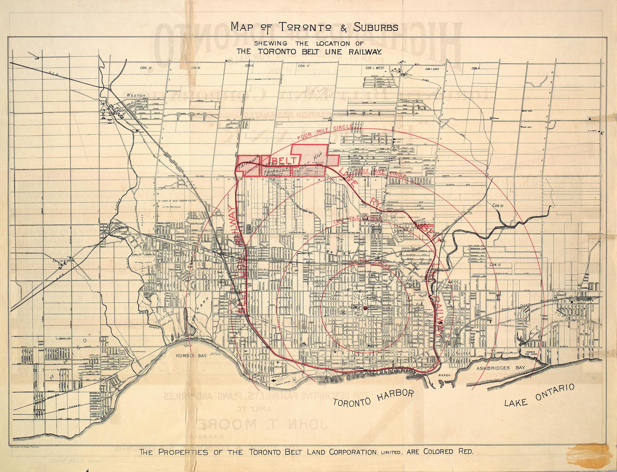
Joan C. Kinsella says there was an Upper Canada College Station ("located north of the College's new grounds") and an Eglinton Station ("on the south side of Eglinton Avenue under the bridge crossing east of Spadina Road". I have seen 2 maps, one showing Eglinton Station but not Upper Canada College Station, an another showing Upper Canada College Station but not Eglinton Station. This explains the awkward wording in the article. TheTrolleyPole (talk) 00:06, 2 March 2017 (UTC)
- I found a map identifying the locations, but not the names, of the seven stations from Rosedale to Fairbank built for the Don Loop. TheTrolleyPole (talk) 21:17, 12 March 2017 (UTC)
Don Station[edit]
This station was mentioned in the article before I started to modify it, but said it was the same as today's Don railway station which "opened" by the CPR in 1896 - two years after the closure of passenger service on the Belt Line. The article's map shows there was a station in the Don Valley near today'd Brick Works. Unless the Belt Line's station was physically moved, the Belt Line station is not the same as the CPR's. The map does not name the Belt Line station in the valley, and I have not found a reference to confirm its name. The article said "none of the stations built for the line exist today" (pre-existing statement without REF), which would be untrue if the CPR station were used by the Belt Line. TheTrolleyPole (talk) 00:22, 2 March 2017 (UTC)
- @TheTrolleyPole:I can't speak to the two items above, but would the CPR station not be on the east side of the brickworks? And if so, that would imply it was rather high in the air, or some distance to the north. In any event, it seems highly unlikely it was called Don station, as that station was rather well known and in an entirely different location. BTW I noticed that there are a few dozen meters of original BL rail still in existence about one meter north of the road on the west end of the parking lot. These were apparently left in place when they pulled up the crossing a few years ago. Maury Markowitz (talk) 19:17, 2 March 2017 (UTC)
- I took a closer look at the vintage map comparing it to Google maps.
The vintage map suggests that the alleged station may have been located where Winchester Street bridge once crossed the Don River.There used to be spur on the west border of the brick works which ran parallel to the old Belt Line right-of-way which was on a 4% upward incline a few metres west of that spur.TheTrolleyPole (talk) 20:59, 3 March 2017 (UTC)- Correction: According to an 1891 map, the station in the Don Valley was located near the site of today's Bayview Avenue interchange with Bloor Street and the Don Valley Parkway.TheTrolleyPole (talk) 23:05, 3 March 2017 (UTC)
- I took a closer look at the vintage map comparing it to Google maps.
- The book "Tales of North Toronto" lists out more stations used by the Belt Line, and these have been incorporated into the article. There was a Belt Line Don Station and a CPR Don Station but they were different. TheTrolleyPole (talk) 22:18, 4 March 2017 (UTC)
- The book "Tales of North Toronto" has a map showing the TBL Don Station located at the north side of Queen Street East and the west side of the tracks. However, the book "Toronto's Railway Heritage" (page 51) has a 1894 photo of the station showing it was located at the south side of Queen Street on the east side of the tracks where the later 1896 CPR station was located. TheTrolleyPole (talk) 20:46, 12 March 2017 (UTC)
Toronto Street Railway[edit]
The Lost Rivers site says "Another factor was the success of Sir William Mackenzie’s Toronto Street Railway, in siphoning off much of the traffic." Other sources repeat this inaccurate statement. The Toronto Street Railway was not owned by Mackenzie. The TSR had lost its franchise to operate streetcars by 1891. When the Belt Line opened, the Yonge streetcar line went only as far north as Summerhill. It would be the Metropolitan Street Railway along with a transfer further south to the streetcars of the Toronto Street Railway (both Mackenzie holdings) that could provide direct competition to the Belt Line. TheTrolleyPole (talk) 02:32, 4 March 2017 (UTC)
Moore Park Station[edit]
The book "Remembering the Don" (page 97) says Moore Park Station remained standing until the early 1930s. The book "Tales of North Toronto' says it was demolished in 1945.TheTrolleyPole (talk) 21:13, 12 March 2017 (UTC)
- Start-Class Canada-related articles
- Low-importance Canada-related articles
- Start-Class Ontario articles
- Low-importance Ontario articles
- Start-Class Toronto articles
- Low-importance Toronto articles
- All WikiProject Canada pages
- Start-Class rail transport articles
- Mid-importance rail transport articles
- All WikiProject Trains pages