Teluk Air Tawar
This article needs additional citations for verification. (May 2017) |
Teluk Air Tawar | |
|---|---|
Suburb of Seberang Perai | |
| Other transcription(s) | |
| • Mandarin | 日落斗哇 |
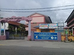
 SK Telok Ayer Tawar from Jalan Telok Ayer Tawar FT1. | |
| Coordinates: 5°28′0″N 100°23′0″E / 5.46667°N 100.38333°E | |
| Country | |
| State | |
| City | |
| District | North Seberang Perai |
| Government | |
| • Local government | Seberang Perai City Council |
| • Mayor of Seberang Perai | Azhar Arshad |
| Area | |
| • Total | 12.5 km2 (4.8 sq mi) |
| Population (2020)[1] | |
| • Total | 21,202 |
| • Density | 1,700/km2 (4,400/sq mi) |
| Demographics | |
| • Ethnic groups | |
| Time zone | UTC+8 (MST) |
| • Summer (DST) | Not observed |
| Postal code | 13050 |
| Area code(s) | +6043 |
Teluk Air Tawar is a suburb of Seberang Perai in the Malaysian state of Penang. Teluk Air Tawar means "Clear water bay" in the Malay language. This seaside town has a scenic view of George Town across the sea.
The town is located along the Malaysia Trunk Road 1 and has fast access to Sungai Petani, the largest city in Kedah for marketing. It also located in the middle of the Malaysian Federal Route 1. The Bertam exit is the north bound exit while the Sungai Dua exit is the south bound exit of the main road.
The town is home to the Royal Malaysian Air Force (RMAF) base. Nearby residential neighbourhoods include Taman Seri Senangan, Taman Wira, Taman Robina, Taman Telok Molek, Taman Pahlawan and Taman Bayu Aman. The town's postcode is 13050 Butterworth.
Demographics[edit]
As of 2020[update], Mukim 7, the subdivision that contains Teluk Air Tawar, was home to a population of 21,202.[1] Malays comprised 71% of the population, followed by Chinese at 19% and Indians at 6%.
Infrastructure[edit]
Expressways[edit]
North bound
- 10 kilometres (6.2 mi) from Hentian Sebelah Tikam Batu (Tikam Batu Side Stop)
- 45 kilometres (28 mi) from Gurun Rest Area
- 95 kilometres (59 mi) from Hentian Sebelah Kepala Batas
South bound
- 42 kilometres (26 mi) from Sungai Juru Rest Area
- 65 kilometres (40 mi) from Hentian Sebelah Sungai Bakap
- 87 metres (285 ft) from Hentian Sebelah Alor Pongsu
See also[edit]
References[edit]
- ^ a b c d "MyCensus 2020: Mukim/Town/Pekan". Department of Statistics Malaysia. Putrajaya: 174–175. February 2024. ISBN 9789672537069.

