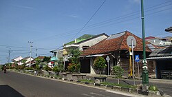
Toboali
Toboali | |
|---|---|
 Jenderal Sudirman Street in Toboali, February 2022. | |
Location of Toboali in Bangka Belitung | |
| Coordinates: 2°59′59″S 106°27′56″E / 2.99972°S 106.46556°E | |
| Country | |
| Province | |
| Regency | |
| Area | |
| • Total | 1,460.34 km2 (563.84 sq mi) |
| Population | |
| • Total | 65,138 |
| • Estimate (2017)[2] | 78,780 |
| • Density | 54/km2 (140/sq mi) |
| Time zone | UTC+7 (Indonesia Western Time) |

Toboali (Chinese: 都保里) is a town in the Indonesian province of Bangka-Belitung, Indonesia. Toboali is the capital of the South Bangka Regency.
Economy[edit]
Significant numbers of the townspeople are employed in pepper cultivation. In the New Order era, tin mining was extensive across the province and a large number of the locals were employed either by the large tin mining corporations or by unconventional mines.
The tourism sector have been growing in the recent years. Tourist destinations include a Dutch-era fortress and the city's natural beaches. In 2016, the local government for the first time held a cultural carnival,[3] aimed to increase the number of tourists coming to the town.
Demographics[edit]
The majority of the people in Toboali are Hakka Chinese and Malay. Majority of Chinese are Buddhist, Catholic or Protestant.
Climate[edit]
Toboali has a tropical rainforest climate (Af) with heavy rainfall year-round.
| Climate data for Toboali | |||||||||||||
|---|---|---|---|---|---|---|---|---|---|---|---|---|---|
| Month | Jan | Feb | Mar | Apr | May | Jun | Jul | Aug | Sep | Oct | Nov | Dec | Year |
| Mean daily maximum °C (°F) | 29.2 (84.6) |
29.6 (85.3) |
30.3 (86.5) |
30.9 (87.6) |
31.4 (88.5) |
31.0 (87.8) |
31.0 (87.8) |
31.5 (88.7) |
31.7 (89.1) |
31.7 (89.1) |
30.8 (87.4) |
29.9 (85.8) |
30.8 (87.4) |
| Daily mean °C (°F) | 26.3 (79.3) |
26.5 (79.7) |
26.8 (80.2) |
27.2 (81.0) |
27.6 (81.7) |
27.2 (81.0) |
27.1 (80.8) |
27.4 (81.3) |
27.4 (81.3) |
27.7 (81.9) |
27.1 (80.8) |
26.7 (80.1) |
27.1 (80.8) |
| Mean daily minimum °C (°F) | 23.5 (74.3) |
23.5 (74.3) |
23.4 (74.1) |
23.6 (74.5) |
23.8 (74.8) |
23.4 (74.1) |
23.3 (73.9) |
23.2 (73.8) |
23.2 (73.8) |
23.7 (74.7) |
23.4 (74.1) |
23.5 (74.3) |
23.5 (74.2) |
| Average precipitation mm (inches) | 221 (8.7) |
167 (6.6) |
205 (8.1) |
212 (8.3) |
255 (10.0) |
194 (7.6) |
139 (5.5) |
123 (4.8) |
109 (4.3) |
196 (7.7) |
265 (10.4) |
262 (10.3) |
2,348 (92.3) |
| Source: Climate-Data.org[4] | |||||||||||||
References[edit]
- ^ "Sensus Penduduk 2010". Badan Pusat Statistik. Indonesian Bureau of Statistics. Retrieved 20 July 2017.
- ^ "BPS Kabupaten Bangka Selatan". BPS Kabupaten Bangka Selatan. Indonesian Bureau of Statistics. Retrieved 20 July 2017.
- ^ Pratama, Riki (2016). "Toboali City on Fire". Bangka Pos. Retrieved 20 July 2017.
- ^ "Climate: Toboali". Climate-Data.org. Retrieved November 11, 2020.

